Anybody has idea why it was called? It's hard to think of "terrace" except a bus terminus and Why Moreton, a person, a company or a place. Hardly find any information from web page.
i saw a photo (on the site of
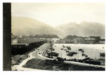
i saw a photo (on the site of today's Bay View Mansion and Sik King House , and Causeway Tower) in a forum about old hong kong , showing buildings which were terrace style. It was believed that the photo was taken at 1930s. They have been demolished for a long time.
Terrace
A terrace is usually a row of houses, often built just down one side of a throughfare or on a hillside. Hong Kong used to be full of them. Oswald Terrace, built just off Wellington Street in the early 1840s was one of the first. Those still existing include Lyndhurst Terrace, Clarence Terrace and Seymour Terrace (the latter in name only). No idea who Moreton was.
in causeway bay
in causeway bay .....
unfortunately ... i could not find out that pic again ....


Comments
Moreton Terrace
The earliest mention I can find is in the 1905 Juror's List. I'm not sure who / what it was named after though.
Regards, David
PS I've moved this from the forum to be a Place. Please choose 'Place' from the 'Create content' menu if you're asking a question about a street or building.
Re moreton terrace
The book Signs of ColonialTimes has this name down as unknown in origin
Here is a picture showing the
Here is a picture showing the terrace :
http://www.flickr.com/photos/35328107@N08/4257151205
Moreton Terrace
Here is a snip from an issue of the SCMP in 1938 with a referrence to Moreton Terrace. It gives a fairly good description of the property detailing six seemingly large homes.
Moreton Terrace
I couldn't get the flicker link to work. My uncle was born in 1 Moreton Terrace in 1938 and I am looking for a photo of nos 1 and 3 from that time if anyone can give a link or if anyone remembers living there.
Moreton Terrace
Hi Kim, I have a couple of clips from the South China Morning Post from around that period. I can't sem to get them uploaded but if you'd like to e-mail me I can send them to you. They deal with 1 and 3. I am looking for info on #4 which was sold in 1937 as far as I can tell. I am trying to find the name of the owner at that time.
My e-mail is seemex98@aol.com
Brian
Here's that Flickr photo of
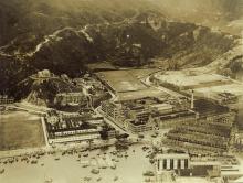
Here's that Flickr photo of Causeway Bay in the 1920s:
Can anyone identify which of the buildings were Moreton Terrace?
Regards, David
Moreton Terrace
David...from that description in the SCMP article the property had six houses which were at one point, home to 78 people. Other references said that the homes were two storied with balconies. There is a mention of Dairy Farm having used land to the north of #6 Moreton Terrace and that it was seperated from #6 by a 15 foot wide lane. I'm wondering if it could be the area to the left of that large center field. There looks like there could be six seperate houses on the right side of that center mound. Then again, maybe this photo was earlier and the Moreton Terrace homes weren't built yet? They seem to have been built about 1913. Could it be they were built soon after on the terraced land at the far right of the photo? Just guessing.
Moreton Terrace
I haven't quite worked out how to attach photos to comments or even to keep track of other comments. I seem to recall seeing a detailed description from someone about being able to distinguish the curve of Leighton Road and of Casueway Road. He also said that the HK Central Library was on the bit of green on the bottom left. I have made 2 photos I wanted to post and will try to do this under places. One is of the 1920's photo flipped so that the water is at the top and another of a current google map with the same orientation. Following the red lines I drew it looks as though the 6 houses on Moreton Terrace may not have been built yet in the 1920's picture here.
I have managed to post the picture and map with my red markings side by side in the 1920's gallery.
Best wishes
Kim
Re: Moreton Terrace
I think Moreton Terrace is that vertical strip of road adjoining the Naval Recreation Grounds (Polo Grounds), On Causeway Road where the tramlines are, I guess those two storey long row of white buildings and further inland were part of Kennedy's Stables. In the 1930s, Bay View Mansions as seen here were built on Moreton Terrace (road) facing the grounds.
Looking at that photo again,
Looking at that photo again, http://gwulo.com/atom/18603, we've got:
I think the taller white buildings at the far end of that road in the photo are the Moreton Terrace buildings.
The clipping from 1913 says there was Dairy Farm's land to the north. The long rows of lower buildings might be Dairy Farm's, or part of the Kennedy's Stables as Moddsey mentions, or even accommodation for workers at the cotton mills as described in the 1913 clipping.
I've updatd the location of the marker above to where I think the Moreton Terrace stood. It's roughly where buildings 1, 5, and 9 Moreton Terrace stand today.
Brian is looking for 4 Moreton Terrace, but the even numbers seem to have disappeared. I believe the terraced building originally had six buildings, numbered 1-6. Later, when the lane became a road named Moreton Terrace, the road would have been re-numbered with odd and even on opposite sides. So instead of 1 / 2 / 3 / 4 / 5 / 6 Moreton Terrace, addresses changed to 1 / 5 / 9 etc.
One suggestion to find out more about the ownership of #4 is to look at the ownership of this portion of land over the years. The tool for that is the government's IRIS system: https://www1.iris.gov.hk/eservices/searchlandregister/search.jsp
You need a lot number first, so to convert addresses to lots head over to the street index: http://gwulo.com/node/10616
Seeral lot numbers are given for the addresses at 1 - 9 Moreton Terrace but the lowest number (and so oldest Lot) is IL (Inland Lot) 1580 so a good start would be to use IRIS to order the history of that Lot, IL 1580.
Regards, David
Kennedy's Dairy Farm
A quick glance of the papers of the day reveals that Mr. John Kennedy also ran a dairy farm in Causeway Bay in addition to the horse repository (Inland Lot No. 1149)..
Moreton Terrace
I come across this picture on Facebook which does show Moreton Terrace in the 1930s as a Terrace