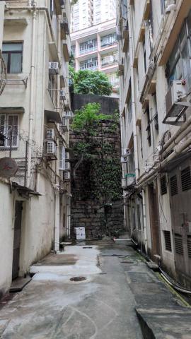
I was looking for somewhere quiet to eat, and came across Sai On Lane Rest Garden, which has a laneway ending in a grand wall that must have been built to support Queens Rd West. I looked at the map here which suggest that long ago there would have been Ouchterlony Battery [c.1857-1865]. The coastline map at oldhkphoto.com suggests the shore would have been behind me, past where Des Veoux Rd is now, except for a stream (?) at Water St.
I'll go and take a closer look at the wall next week. Presumably it is just one small exposed segment of a much longer stretch.
Re: Streams
Hi there,
The stream along Water street is still there, but it went underground. A section of it could still be traced across at Hing Hon Road.
About 100 years ago, there used to be a nullah along Hill Road. The stream there could be traced inside the HKU campus. It is still above ground above University Drive.
T
To have Queens Rd West and…
To have Queens Rd West and the nullah as well, there must have been a bridge over Water Street, right?
The 1882 map is a good one…
The 1882 map is a good one to see the route of the streams: https://gwulo.com/map-of-places#17~22.28561~114.13906~Map_by_GovHK-1882…
Interesting that it shows as…
Interesting that it shows as Battery Hill Rd, not Queens rd West in the older maps.
And the 1980 map shows a big red star at about the right spot. Any idea what that is? I couldn't find a key to the map.
Re: Street View at Pokfulam Road
Hi There,
I remember there is an old photo here showing the crossing where Water Street met Pokfulam Road. I could not locate the old link, but you may have a look at the location through Street View.
T
re: a big red star
The big red stars show the location of cinemas - in this case the Tai Ping Theatre.
Thanks for idnetifying the…
Thanks for idnetifying the red star!
I went back today, and found the small section of exposed wall pognant. Perhaps the stonework continues for much of the northern side of Queens Rd West, but is almost entirely covered up by subsequent buildings, stairways, roadworks etc