The new Gwulo book continues ...
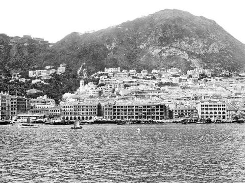
What a dramatic sight this must have been – such a contrast to the visitors’ ocean voyage. Their last few days had been spent looking at the featureless horizon, but here the sheer face of the Peak rises high above the city. The clean sea breeze is replaced by the smells and sounds of the city, and the open sea traded for a harbour that’s busy with boats of all shapes and sizes.
Let’s take a closer look, starting at the top of the photo. If you follow the skyline from left to right, you’ll see it forms a shallow ‘V’. The bottom of that V is Victoria Gap, where the Peak Tram line ends.
Continue right, rising up over a low hill, then dipping to reach a long building. If the tourists had arrived a few years earlier they could have stayed there, as the long building was built as the Mount Austin Hotel. But by this time the hotel business had failed. The building became the Mount Austin Barracks, so in 1906 the residents were British soldiers.
Below the barracks are the steep slopes of the Peak, barren until we reach these grand houses along Conduit Road.

The grandest of them all was Marble Hall at top left. It was Sir Catchick Paul Chater’s house, and it had a fantastic view over the city to the seafront and the harbour beyond. The seafront held a special interest for Chater. He was the driving force behind the recent project to reclaim land along Hong Kong’s north shore, creating the new Connaught Road. By 1906 the reclamation was all finished, but Chater could still admire the new buildings rising up along the water’s edge.

The tall building on the left was Hotel Mansions, completed in 1905. In front of it, Blake Pier extends into the harbour from the end of Pedder Street. The pier is where our tourists would first step ashore, ferried there from their ship on a launch like the one in the foreground above. Above the launch is an open area, showing a mass of bamboo scaffolding. It’s a sure sign that a large construction project was underway. In this case they’re building the new General Post Office (GPO). That’s our clue that dates the photo to around 1906.
At the right edge of the photo, Connaught Road has two empty plots.

We know they’re empty because we can see through to the shorter, older buildings back on Des Voeux Road. The older building on the right with a circle in its gable is an earlier version of Central Market.
Back on the main photo, draw a line between the GPO and Marble Hall. About half way along, you’ll see this pair of buildings: the Roman Catholic Cathedral, and its free-standing bell tower. They’ll have their own story to tell later in the book.

We’re going to stay with this view for the next few photos, but you’ll see how it changes over the years.

Comparing this view with the previous photo, an obvious change is the white line running across the face of the Peak: that’s Lugard Road. Most new roads in Hong Kong were built to open up new land for sale and so turn a profit, but Lugard Road was to be different:
'Though a few building sites will be rendered available on a spur below the signalling flagstaff, the road will be principally used as a promenade, a wonderful panoramic view of the City, Harbour and surroundings being obtainable from it.'
The new road fulfilled its promise of ‘a wonderful panoramic view’, and has been one of Hong Kong’s most popular walks ever since.
The mood isn’t so happy down in mid-levels. Chater is probably feeling a bit grumpy that new buildings overlook his Marble Hall.

On the bright side, this was the limit – any higher up, the slope is just too steep to build on. Even today, the buildings above Conduit Road stand on the same sites as these grand old houses.
What about a date for this view? Lugard Road is our first clue. It was built in two halves, east and west. The east section could be cut into the hillside, so was easier to build. It was finished first, in 1914. The west section passes over much steeper hillside. It had to be built as a raised pathway on concrete columns, forming that white line we can see. This section was finished in 1921. The photo wasn’t taken much later than that, though, as I can still see two empty plots along the seafront. They’ll be filled in by the mid-1920s, so I’ll go with 1922 or thereabouts.
The next chapters show how this view - and Hong Kong - changed in the 1930s, 50s, and 60s.
I've been looking at the printed digital proofs of the pages today (Friday, 22 November), and the photos are looking great. I did find two small problems though: one photo had been cropped too tightly, and another had a dirty mark in the sky that I'd missed. Those will be updated over the weekend, ready to go back to the printer on Monday. Then I'm crossing my fingers that the printer can squeeze us in to their schedule later in the week. Once printing begins we'll have a better idea of when the printed books will be delivered.
Further reading...
- View more sample chapters:
- Photo (1): Sulphur Channel
- Photo (2): Central and the Peak, c. 1906
- Photo (21): Kowloon City Pier
- Photo (22): Farewell!
- Or buy the book.