6 PB15 came up in discussion. This pillbox was at Deepwater Bay, and – as far as is known – right where the Victoria Recreation Club building now is. Does anyone (and I’m not holding my breath…) have a photo of the site before the VRC was built?
Unfortunately the wartime maps aren't very clear. Here's a map of the area with a few relevant places marked:
The HK Island map of pillboxes shows PB14 at position A, PB 15 at position B, then PB 16 (which still exists today) at position D. That seems strange, as then there is no pillbox on Deep Water Bay beach.
There is a more detailed 1:20,000 map of pillboxes, just covering the coastline from Sandy Bay around to the western edge of Deep Water Bay. Unfortunately it doesn't show the Deep Water bay beach area, but it does show the same area where PB's 14 and 15 are shown on the island map. PB 14 is shown in about the same place as it appears on the island map. But PB 15 isn't shown, suggesting perhaps the island map's location for PB 15 was incorrect.
Tony's suggested location for PB 15 (position C on the map) makes more sense, but a photo would be the best way to confirm it.
I've searched for old photos of deep water bay in the government's image websites, but couldn't find any that give a clear view of the area where the VRC stands. Can anyone help please?
You might like to take a look at this location. There is the remains of a concrete hut besides the stairs, which is listed in some other sites or books concerning warm time structures. There is also the remains of a platform where the white cladded guy stood in the photo. This location looked very much like other reported search light post I saw on the Net.
The following photo shows the same location at a closer range and from another angle. The platform mentioned before with the guy in white is clearly visible.
Here's an updated map, with T's place added as point E. As T mentions it looks like a searchlight position, I wonder if it could have been the position of Lyon Light 15?
The Lyon Light connection comes from another, rather grisly entry on Tony Banham's site. The 4 July 2008 entry reads:
4 Elizabeth Ride sent a note including her father’s witness statement for the War Crimes Trials: “On the steps leading to Lyon Light No. LL15 by the roadside, west of Deep Water Bay, were the bodies of 6 Middlesex ORs, recognisable by their hosetops. Their hands and feet were still tied. There were large blood stains on the cutting and the roadside on the opposite side of the road, and streaks of blood stretching from this, across the road to the steps where the bodies lay in a heap. Their heads had been almost completely severed by sword cuts." Rob Weir reckons that PB 15 and Lyon Light 15 were on the site of today’s Victoria Recreation Club (VRC) at the western end of Deepwater Bay – a place where I’ve enjoyed a beer or two in the past.
Unfortunately the description 'by the roadside, west of Deep Water Bay' doesn't help, as that could apply to either position C or E on the map.
It's the first I've heard of Lyon Lights, but a couple of Legco entries confirm they were a 'light searchlight for beach defence':
HON. SIR HENRY POLLOCK.—What is the Lyon Light Section? THE CHAIRMAN.—It is new a section, a sort of minor searchlight unit. Lyon Light Section is merely its name. I will furnish the Council later with a description of the Lyon Light.
THE CHAIRMAN.—With reference to the Hon. Mr. Paterson's questions at the last meeting, I can say that the Bren Light Machine Guns were not purchased as there were none available. The Lyon Light, as I thought, is a light searchlight for beach defence.
Does anyone know if Lyon Lights were normally positioned next to a pillbox, or some distance away?
The Island Road alone the coast towards Deep Water Bay from Wong Chuk Hang was different back then. Even back in the late 1970's or early 1980's it was just a one lane road.
Last time when I was walking towards the possible search light posotion, I remember I saw some concrete slaps on the rocky slopes close to the Mils & Chung path. They also go under the widened lane. Those might be the remains of the steps mentioned in Mr Banham's site. Unfortunately I did not take any photos of these. Maybe next time.
If there had been any military structure there when they built that facility in the background they might have it destroyed already. But hey, this is just a photo from a distance.
There were large blood stains on the cutting and the roadside on the opposite side of the road, and streaks of blood stretching from this, across the road to the steps...
So the steps would have been opposite an area where the hillside had been cut back (the 'cutting') to make way for the road. Looking at your photos from across the shore, that description could fit location C or E, so there's still no clear answer.
Though as you mention, the road in the 1940s may have followed a slightly different route. If the cutting was smaller then, it might help clarify the location of LL 15.
That section of Island Road had been widen as well as straighten up. Part of the spurs had been cut further back, and part of the west bound land was built like a bridge. I'll see if I could hop over there again in the near future and take some more photos about the steps I spotted last time. The steps is no longer visible from Island Road as it is now under the west bound lane, but its remains could still be seen from the Mils & Chung Path below.
Last week I walked along the Mills & Chung path (odd name!) to look at the possible searchlight position (position E on the map). Here is close-up of the small concrete platform. It looks like originally there were six bolts in a hexagon shape for mounting something.
The small concrete structure behind only has one opening - the small door at the back, which we can see in T's photos. On the left side there is a pipe leading out at the bottom.
If anyone has seen Lyon Light installations elsewhere, do they have similar arrangements of bolts and a small concrete hut?
MrB
PS There are some signs of concrete steps up the rocks, but they look as though they may have just been for temporary use while the road was being built.
PB14 is just a few metres further along the shore from the left hand edge of this photograph. Its gun slits are just above the ground level and I was able to see inside a year or so ago. The Lyon light shelter is up an overgrown flight of steps to the left of the pill box and it is well worth visiting.
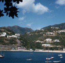
Just a new photo from another angle across the bay. If there was a pillbox nearby it might have already been destroyed when the HK Electric constructed the conduit.
Great photo. The little white blob immediately below the road is definitely the Lyon Light Shelter. As T suggests, it probably disappeared when the road was widened. If you draw a vertical line down from the LL, the white block on the water's edge is probably the PB. That is the best information I have.
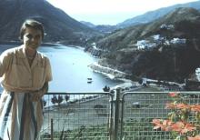
The object to the left of the VRC is apparently the LL Shelter. It sat on top of a tall concrete pillar, with the back against the cliff, and the top being almost at road level. It survived into the 1970's. As the VRC is shown, PB 15 has gone, as they occupied roughly the same section of the beach.
Comments
Looking for old (1940s-60s) photos of Deep Water Bay
Let's see if we can help Tony Banham out. In the 6 Sep 2008 entry on his website, he writes:
Unfortunately the wartime maps aren't very clear. Here's a map of the area with a few relevant places marked:
[gmap markers=letters::22.243715145276997,114.17852908372879 + 22.244737974585863,114.17930155992508 + 22.245591981685962,114.18544918298721 + 22.237081469087162,114.18882876634598 |zoom=15 |center=22.24262941543094,114.1823673248291 |width=640px |height=400px |control=Small |type=Satellite]
The HK Island map of pillboxes shows PB14 at position A, PB 15 at position B, then PB 16 (which still exists today) at position D. That seems strange, as then there is no pillbox on Deep Water Bay beach.
There is a more detailed 1:20,000 map of pillboxes, just covering the coastline from Sandy Bay around to the western edge of Deep Water Bay. Unfortunately it doesn't show the Deep Water bay beach area, but it does show the same area where PB's 14 and 15 are shown on the island map. PB 14 is shown in about the same place as it appears on the island map. But PB 15 isn't shown, suggesting perhaps the island map's location for PB 15 was incorrect.
Tony's suggested location for PB 15 (position C on the map) makes more sense, but a photo would be the best way to confirm it.
I've searched for old photos of deep water bay in the government's image websites, but couldn't find any that give a clear view of the area where the VRC stands. Can anyone help please?
Regards, MrB
A possible search light post between locations B & C
Hi there,
You might like to take a look at this location. There is the remains of a concrete hut besides the stairs, which is listed in some other sites or books concerning warm time structures. There is also the remains of a platform where the white cladded guy stood in the photo. This location looked very much like other reported search light post I saw on the Net.
The following photo shows the same location at a closer range and from another angle. The platform mentioned before with the guy in white is clearly visible.
See the entrance to the hut:
Yet from another angle:
Further towards location B we have this:
Best Regards,
T
re: A possible search light post between locations B & C
Here's an updated map, with T's place added as point E. As T mentions it looks like a searchlight position, I wonder if it could have been the position of Lyon Light 15?
[gmap |markers=letters::22.24370852502352,114.17848482728004 + 22.244756180243144,114.17931094765663 + 22.245560535805673,114.18544247746468 + 22.23709471029586,114.18868258595467 + 22.245217940406825,114.1840249300003 |zoom=15 |center=22.24123913925391,114.18567180633545 |control=Small |type=Satellite]
The Lyon Light connection comes from another, rather grisly entry on Tony Banham's site. The 4 July 2008 entry reads:
Unfortunately the description 'by the roadside, west of Deep Water Bay' doesn't help, as that could apply to either position C or E on the map.
It's the first I've heard of Lyon Lights, but a couple of Legco entries confirm they were a 'light searchlight for beach defence':
Does anyone know if Lyon Lights were normally positioned next to a pillbox, or some distance away?
MrB
Island Road then
Dear Mr B,
The Island Road alone the coast towards Deep Water Bay from Wong Chuk Hang was different back then. Even back in the late 1970's or early 1980's it was just a one lane road.
Last time when I was walking towards the possible search light posotion, I remember I saw some concrete slaps on the rocky slopes close to the Mils & Chung path. They also go under the widened lane. Those might be the remains of the steps mentioned in Mr Banham's site. Unfortunately I did not take any photos of these. Maybe next time.
Best Regards,
Thomas
Location A
Hi there,
I dig into my photos and found this:
If there had been any military structure there when they built that facility in the background they might have it destroyed already. But hey, this is just a photo from a distance.
Locations from acrose the shore
Another landmark
Looking at the quote again, there's the section:
So the steps would have been opposite an area where the hillside had been cut back (the 'cutting') to make way for the road. Looking at your photos from across the shore, that description could fit location C or E, so there's still no clear answer.
Though as you mention, the road in the 1940s may have followed a slightly different route. If the cutting was smaller then, it might help clarify the location of LL 15.
MrB
Island Road Then
Hi Mr B,
That section of Island Road had been widen as well as straighten up. Part of the spurs had been cut further back, and part of the west bound land was built like a bridge. I'll see if I could hop over there again in the near future and take some more photos about the steps I spotted last time. The steps is no longer visible from Island Road as it is now under the west bound lane, but its remains could still be seen from the Mils & Chung Path below.
Best Regards,
T
Possible Lyon Light
Last week I walked along the Mills & Chung path (odd name!) to look at the possible searchlight position (position E on the map). Here is close-up of the small concrete platform. It looks like originally there were six bolts in a hexagon shape for mounting something.
The small concrete structure behind only has one opening - the small door at the back, which we can see in T's photos. On the left side there is a pipe leading out at the bottom.
If anyone has seen Lyon Light installations elsewhere, do they have similar arrangements of bolts and a small concrete hut?
MrB
PS There are some signs of concrete steps up the rocks, but they look as though they may have just been for temporary use while the road was being built.
PB14 is just a few metres
PB14 is just a few metres further along the shore from the left hand edge of this photograph. Its gun slits are just above the ground level and I was able to see inside a year or so ago. The Lyon light shelter is up an overgrown flight of steps to the left of the pill box and it is well worth visiting.
My previous comment relates
My previous comment relates to the top photograph in this sequence - the one showing the blue pipe leading into the sea.
Re: LL15 from across the bay
Hi there,
Just a new photo from another angle across the bay. If there was a pillbox nearby it might have already been destroyed when the HK Electric constructed the conduit.
Best Regards,
T
PB15 location
Rob Weir's comments on the 1953 photo:
Great photo. The little white blob immediately below the road is definitely the Lyon Light Shelter. As T suggests, it probably disappeared when the road was widened. If you draw a vertical line down from the LL, the white block on the water's edge is probably the PB. That is the best information I have.
Rob's notes
Year completed is: Approximate
Condition at last visit: Demolished
Date of last visit: Dec-1995
Ref: ROB-00614
Other:
New Photo of Pillbox
The below photo shows either the Deepwater Bay pillbox or the Lyon Light lower left but I'm not sure which is which.
Deepwater Bay PB and LL Light
The object to the left of the VRC is apparently the LL Shelter. It sat on top of a tall concrete pillar, with the back against the cliff, and the top being almost at road level. It survived into the 1970's. As the VRC is shown, PB 15 has gone, as they occupied roughly the same section of the beach.