mental hospital and surrounding buildings , by WYIP
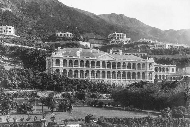
This nice photo of the Hong Kong Mental Hospital building appears to have been taken in the 1890s. The reason is that the building in the photo looks brand new. Looks like this photo was taken shortly after it was completed in 1892. As stated on the original post, this building was originally built for the mental hospital staff living quarters, and the hospital was actually located on the right side of the photo (See marker C). This building is located on the east end of High Street, and the address is No.2 High Street. A map from the turn of the century called this place, “lunatic asylum”. High Street is relatively flat except on the east end, where it slopes upwards to merge with Bonham Road. The photo appears to have been taken from Hospital Road. The garden in front of the building is the King George V Memorial Park. Back in the late fifties, I was in this building to visit my grand uncle and his family, who they took residence there. At that time, he was the resident doctor there.
This high-resolution photo allows me to point out some of the buildings in the background so that I can share them with other Gwulo readers.
A: Mental Hospital main building – originally built as the mental hospital staff living quarters. Completed in 1892.
B: King George V Memorial Park
C: Mental Hospital – This was originally the main building of the mental hospital. Back then, the map identified this place as “lunatic asylum”
D: Lower Richmond Road – Became Lyttleton Road in 1904
E: Richmond Terrace – private residence developed by Richmond Terrace Estate and Building Co.
F: Hartley – private residence developed by Richmond Terrace Estate and Building Co.
G: Rose Villa – Originally a private residence, it became Diocesan School For Girls in 1899. The address was No. 62 Bonham Road.
H: High West – The mountain located next to Victoria Peak on the west side.
J: Tarrawera – private residence
K: Eastley – private residence developed by the Richmond Terrace Estate and Building Co.
L: Upper Richmond Road – This road was built as part of the private residential development in that area by the Richmond Terrace Estate and Building Company. Some earlier maps identify this road as just Richmond Road. In 1904, this road was incorporated as part of Robinson Road.
M: Diocesan Boy’s School & Orphanage – In this photo, only the roof is shown. The rest of the building is blocked by the mental hospital building. It was demolished and rebuilt as Northcote Teacher College.
N: Robinson Road – This section of Robinson Road is now called Park Road. It was renamed Park Road when Upper Richmond Road became part of Robinson Road in 1904.
O: High Street – This is the part of High Street that slopes upwards to merge with Bonham Road. The road is behind the bushes growing along this section of High Street. The retaining wall between High Street and the park below is clearly visible.
Comments
Yes, it is the Medical Staff…
Yes, it is the Medical Staff Quarters / Mental Hospital building on High Street
Mental Hospital & Surrounding Buildings
This nice photo of the Hong Kong Mental Hospital building appears to have been taken in the 1890s. The reason is that the building in the photo looks brand new. Looks like this photo was taken shortly after it was completed in 1892. As stated on the original post, this building was originally built for the mental hospital staff living quarters, and the hospital was actually located on the right side of the photo (See marker C). This building is located on the east end of High Street, and the address is No.2 High Street. A map from the turn of the century called this place, “lunatic asylum”. High Street is relatively flat except on the east end, where it slopes upwards to merge with Bonham Road. The photo appears to have been taken from Hospital Road. The garden in front of the building is the King George V Memorial Park. Back in the late fifties, I was in this building to visit my grand uncle and his family, who they took residence there. At that time, he was the resident doctor there.
This high-resolution photo allows me to point out some of the buildings in the background so that I can share them with other Gwulo readers.
A: Mental Hospital main building – originally built as the mental hospital staff living quarters. Completed in 1892.
B: King George V Memorial Park
C: Mental Hospital – This was originally the main building of the mental hospital. Back then, the map identified this place as “lunatic asylum”
D: Lower Richmond Road – Became Lyttleton Road in 1904
E: Richmond Terrace – private residence developed by Richmond Terrace Estate and Building Co.
F: Hartley – private residence developed by Richmond Terrace Estate and Building Co.
G: Rose Villa – Originally a private residence, it became Diocesan School For Girls in 1899. The address was No. 62 Bonham Road.
H: High West – The mountain located next to Victoria Peak on the west side.
J: Tarrawera – private residence
K: Eastley – private residence developed by the Richmond Terrace Estate and Building Co.
L: Upper Richmond Road – This road was built as part of the private residential development in that area by the Richmond Terrace Estate and Building Company. Some earlier maps identify this road as just Richmond Road. In 1904, this road was incorporated as part of Robinson Road.
M: Diocesan Boy’s School & Orphanage – In this photo, only the roof is shown. The rest of the building is blocked by the mental hospital building. It was demolished and rebuilt as Northcote Teacher College.
N: Robinson Road – This section of Robinson Road is now called Park Road. It was renamed Park Road when Upper Richmond Road became part of Robinson Road in 1904.
O: High Street – This is the part of High Street that slopes upwards to merge with Bonham Road. The road is behind the bushes growing along this section of High Street. The retaining wall between High Street and the park below is clearly visible.