Thanks for posting your pics Bob. Very interesting. The amount of space in places such as Lantau, so close to Hong Kong but so different, always amazed me.
Although their foregrounds are different, I reckon the islands in the distance are the same in this other pic you posted, meaning they were both taken from places not far apart.
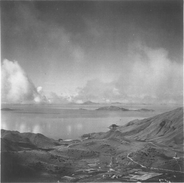
I think the bay and beach nearest the camera in your "View from Lantau Peak" photo, dated 1955, is Shek Pik - an area transformed just a few years later when the valley behind became Shek Pik Reservoir. If so, both pics were taken from somewhere close to Lantau Peak looking towards the south-west.
For comparison purposes, have a look at the beach and two small headlands on the left of the following photo. Same as in your 1955 photo I think.
View towards Shek Pik from Po Lin monastery, by Admin
Looking at current pictures of that area, I was looking to the south west in those photos. What I do notice in current pictures is an abundance of trees, whereas in 1955 it was grassland.
The Monastery's website says the pagoda was built in 1953, so that fits with Bob's dates. But I haven't been able to work out a view that lines up the pagoda and the other features.
In HKMS 2.0 website, before we open the photo for viewing, in the background there should be an overlay with the present day map with a green square, which represented the area the photo covers. But still, it is very difficult to figure it out. The orientation as well as the present day over grown slopes makes it very difficult.
The main photo is looking south west towards where Shek Pik reservoir now stands, there is a reasonable view on GoogleEarth here. With that in mind, it would make the main photo's pagoda somewhere close to the the reservoir, so I think that rules out the pagoda of the flower ornament sutra. Perhaps the one in the top photo was a victim of the construction?
Checked HKMS 2.0. There are only two sets of aerial photos of the area for this period, one dated 1956 and the other 1962. However both sets were shot at 16700 and 30000 ft respectively, not much to see from a small screen. For the 1962 set, Shek Pik Reservoir was in its last leg of construction. Photo only show desolation of the site.
If we could get the survey maps of pre-Shek Pik Reservoir........
I have spent far to long looking at this picture trying to work out where it was taken but I'm pretty certain that the Pagoda is the Flower Ornament Sutra Pagoda (also called Wah-Yen or Hua-Yan) at Po Lin Monastery. Looking at the aerial image below from 20 October 1954 The Pagoda can be seen bottom centre as a white patch on top of the hill with the square of fields below to the left
In Bob's original photo if you follow the contours of the mountains around it becomes clear the pagoda is pretty high up on Lantau - far beyond what was flooded by the reservoir. There is also almost no farmland/paddy fields around which do not match any of the aerial photos of the Pik Shek area taken at a similar time.
If you look at the aerial photos on hkmaps from 1963 the paths around the Flower Pagoda also line up with the visible ones in Bobs photo. Bob was standing on the slopes/top of Nei Lak Shan when he took it.
I'm coming around to Herostratus' thinking. Looking more carefully at the original image, what I though was flat land to the coast is an optical illusion and instead the pagoda appears to be on land that is above where the reservoir is located. So that would put Bob up Nei Lek Shan - or at least somewhere close to the summit - when he took the image. If you line up the summit of Nei Lek Shan with Shek Pik reservoir on GoogleEarth you can see that Herostratus is correct and the pagoda is exactly where you would expect it to be.
I'm not sure if this will work but if you click this GoogleEarth link I'm hoping it takes you to where I amdescribing. For reference the pagoda is located just to the left of the buddha.
Tom - The aerial photo you linked in your post of 9th Feb does show the pagoda towards the bottom, center.
Alan - Apologies, I should have paid more attention to your post of 9th Feb.
Herostratus - Excellent work finding the oblique aerial photo. The pattern and relative positions of fields, paths, buildings and the pagoda in that photo are much easier to interpret than in the vertical aerial photos and impossible to argue with.
The Flower Ornament Sutra Pagoda, aka Wah Yen, aka Hua Yan, at Po Lin Monastery it is! It already has a "place" page, so I’ve added it as a "place" seen in the photo at the head of this string and deleted the Shek Pik Pagoda "place" page.
New finding also showed the small hill on the left hand side of the pagoda is Muk Yue Shan, where the Big Buddha resides. The top of the Pagoda could be seen from the upper section of the grand stairs there, as well as from the platform.
T
ps Obviously I had been talking about the 1963 aerial photo for this, instead of the main photo.
given that this (the original image) is a SW view (more or less) from Nei Lak Shan (彌勒山), the location of today's big buddha should be out of frame to the right (i.e west) of the pagoda's position.
In 1961, members of the China Art Association went to Lantau Island for sketching, using painting to record the environment around the Pagoda of the Flower Ornament Sutra.
Comments
That may be the Bernacchi…
That may be the Bernacchi house and plantation in the foreground.
Can anyone recognise the…
Can anyone recognise the pagoda at bottom right?
This satellite view shows there are are several pagodas around Tei Tong Tsai, so perhaps it is one of them? https://gwulo.com/map-of-places#18~22.25795~113.92485~Satellite_by_GovH…
Shek Pik
Thanks for posting your pics Bob. Very interesting. The amount of space in places such as Lantau, so close to Hong Kong but so different, always amazed me.
Although their foregrounds are different, I reckon the islands in the distance are the same in this other pic you posted, meaning they were both taken from places not far apart.
I think the bay and beach nearest the camera in your "View from Lantau Peak" photo, dated 1955, is Shek Pik - an area transformed just a few years later when the valley behind became Shek Pik Reservoir. If so, both pics were taken from somewhere close to Lantau Peak looking towards the south-west.
For comparison purposes, have a look at the beach and two small headlands on the left of the following photo. Same as in your 1955 photo I think.
view from Lantau peak
Looking at current pictures of that area, I was looking to the south west in those photos. What I do notice in current pictures is an abundance of trees, whereas in 1955 it was grassland.
Re: looking SW
Hi GW,
Now you brought that up, that is interesting. I noted something was off but could place it when I first looked at the two photos.
Now I wonder what had been that Pai Lau and the Pagoda.
T
About the Pagoda
Could the pagoda in the photo possibly be the Pagoda of the Flower Ornament Sutra (華嚴塔) ?
source : https://plm.org.hk/eng/history.php
Re: older aerial photos
Hi There,
Just tried HKMS 2.0. There are limited number of photos of over 10000 feet in the area, difficult to view from a 2 in 1 ultra book screen.
T
Re: 1963 aerial photo
Hi There,
May have found a photo dated 1963 showing the area. Sort of difficult wrapping our minds around the photos though.
https://www.hkmapservice.gov.hk/OneStopSystem/map-search/getPreviewFile…
T
re: About the Pagoda
I've made a Place for the pagoda at https://gwulo.com/node/59949
The Monastery's website says the pagoda was built in 1953, so that fits with Bob's dates. But I haven't been able to work out a view that lines up the pagoda and the other features.
The 1963 aerial photos of the area can be seen at https://www.hkmaps.hk/viewer.html by selecting layers 1963.2 or 1963.4.
Re: About the pagoda
Hi There,
In HKMS 2.0 website, before we open the photo for viewing, in the background there should be an overlay with the present day map with a green square, which represented the area the photo covers. But still, it is very difficult to figure it out. The orientation as well as the present day over grown slopes makes it very difficult.
The pagoda should still be there, hidden.
T
pagoda
The main photo is looking south west towards where Shek Pik reservoir now stands, there is a reasonable view on GoogleEarth here. With that in mind, it would make the main photo's pagoda somewhere close to the the reservoir, so I think that rules out the pagoda of the flower ornament sutra. Perhaps the one in the top photo was a victim of the construction?
Re: probably under water
Hi Phil,
Checked HKMS 2.0. There are only two sets of aerial photos of the area for this period, one dated 1956 and the other 1962. However both sets were shot at 16700 and 30000 ft respectively, not much to see from a small screen. For the 1962 set, Shek Pik Reservoir was in its last leg of construction. Photo only show desolation of the site.
If we could get the survey maps of pre-Shek Pik Reservoir........
T
Shek Pik Pagoda
I've made a "place" for this pagoda. Please see https://gwulo.com/59982 .
I have spent far to long…
I have spent far to long looking at this picture trying to work out where it was taken but I'm pretty certain that the Pagoda is the Flower Ornament Sutra Pagoda (also called Wah-Yen or Hua-Yan) at Po Lin Monastery. Looking at the aerial image below from 20 October 1954 The Pagoda can be seen bottom centre as a white patch on top of the hill with the square of fields below to the left
In Bob's original photo if you follow the contours of the mountains around it becomes clear the pagoda is pretty high up on Lantau - far beyond what was flooded by the reservoir. There is also almost no farmland/paddy fields around which do not match any of the aerial photos of the Pik Shek area taken at a similar time.
If you look at the aerial photos on hkmaps from 1963 the paths around the Flower Pagoda also line up with the visible ones in Bobs photo. Bob was standing on the slopes/top of Nei Lak Shan when he took it.
Wah Yen pagoda
I'm coming around to Herostratus' thinking. Looking more carefully at the original image, what I though was flat land to the coast is an optical illusion and instead the pagoda appears to be on land that is above where the reservoir is located. So that would put Bob up Nei Lek Shan - or at least somewhere close to the summit - when he took the image. If you line up the summit of Nei Lek Shan with Shek Pik reservoir on GoogleEarth you can see that Herostratus is correct and the pagoda is exactly where you would expect it to be.
I'm not sure if this will work but if you click this GoogleEarth link I'm hoping it takes you to where I amdescribing. For reference the pagoda is located just to the left of the buddha.
Pagoda of the Flower Ornament Sutra
Well done Tom Ngan, Alan Ho and Herostratus,
Tom - The aerial photo you linked in your post of 9th Feb does show the pagoda towards the bottom, center.
Alan - Apologies, I should have paid more attention to your post of 9th Feb.
Herostratus - Excellent work finding the oblique aerial photo. The pattern and relative positions of fields, paths, buildings and the pagoda in that photo are much easier to interpret than in the vertical aerial photos and impossible to argue with.
The Flower Ornament Sutra Pagoda, aka Wah Yen, aka Hua Yan, at Po Lin Monastery it is! It already has a "place" page, so I’ve added it as a "place" seen in the photo at the head of this string and deleted the Shek Pik Pagoda "place" page.
Many thanks.
Re: Muk Yue Shan
Hi There,
New finding also showed the small hill on the left hand side of the pagoda is Muk Yue Shan, where the Big Buddha resides. The top of the Pagoda could be seen from the upper section of the grand stairs there, as well as from the platform.
T
ps Obviously I had been talking about the 1963 aerial photo for this, instead of the main photo.
Nei Lak Shan
given that this (the original image) is a SW view (more or less) from Nei Lak Shan (彌勒山), the location of today's big buddha should be out of frame to the right (i.e west) of the pagoda's position.
The Pagoda in the painting, 1961