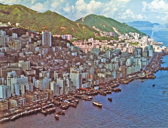
This is a relatively rare aerial photo of the Westpoint, the mid-level section above Westpoint, and part of Sheung Wan (on the left side of the photo) of Hong Kong Island. Most of the aerial photos of Hong Kong Island are in the Central District. This is a rare treat (at least to me). Based on the buildings in the photo, I would guess it was taken between 1970 and 1971. This is based on the high rises that can be seen in the photo. The 26-story high rise (called Prospect Place, 88 Bonham Road) across the street from King’s College has already been built. Construction of this high rise was started in 1969. And was completed in 1971. In the photo, the Knowles Architecture building, located next to the HKU Lok Yeo (main) building, was not built yet (not seen in the photo). The groundwork of this building began in 1970-71 and the building took shape in 1972. This is how I determined when this photo was taken.
There is another interesting observation in this photo and that is the garbage incinerator in Kennedy Town was already in operation with smoke belching from the smoke stack. This can be seen on the far right hand side of this photo. The incinerator was built in 1967.
This photo also provides a very nice profile of the “Hill above Belchers” (now called Lung Fu Shan) and Mount Davis. Lung Fu Shan, on the left side of the photo, has two peaks, one higher than the other, and Mount Davis is in the middle of the photo. The “Hill above Belchers” was just called Battery Hill (unofficially) back in the sixties and seventies. Somehow, the name was changed to Lung Fu Shan in the eighties or nineties. The reason is unknown to me.
Comments
Nice aerial view of the West Point
This is a relatively rare aerial photo of the Westpoint, the mid-level section above Westpoint, and part of Sheung Wan (on the left side of the photo) of Hong Kong Island. Most of the aerial photos of Hong Kong Island are in the Central District. This is a rare treat (at least to me). Based on the buildings in the photo, I would guess it was taken between 1970 and 1971. This is based on the high rises that can be seen in the photo. The 26-story high rise (called Prospect Place, 88 Bonham Road) across the street from King’s College has already been built. Construction of this high rise was started in 1969. And was completed in 1971. In the photo, the Knowles Architecture building, located next to the HKU Lok Yeo (main) building, was not built yet (not seen in the photo). The groundwork of this building began in 1970-71 and the building took shape in 1972. This is how I determined when this photo was taken.
There is another interesting observation in this photo and that is the garbage incinerator in Kennedy Town was already in operation with smoke belching from the smoke stack. This can be seen on the far right hand side of this photo. The incinerator was built in 1967.
This photo also provides a very nice profile of the “Hill above Belchers” (now called Lung Fu Shan) and Mount Davis. Lung Fu Shan, on the left side of the photo, has two peaks, one higher than the other, and Mount Davis is in the middle of the photo. The “Hill above Belchers” was just called Battery Hill (unofficially) back in the sixties and seventies. Somehow, the name was changed to Lung Fu Shan in the eighties or nineties. The reason is unknown to me.
Here's another view of the…
Here's another view of the incinerator:
And lots more aerial photographs to explore: https://gwulo.com/taxonomy/term/3581/photos?items_per_page=All