A Point marked as "E/F/P" was identified on the print map of "Kowloon" 1:600 137-SW-12 (Ed 1922)" recently bought from the Survey and mapping Office, Hong Kong.
When using the hkmaps viewer (reference map 1922.1), the same "Point" can be identified and the coordinates approximate as follow.
Longitude: 114.17357 Latitude: 22.31160
Using the overlay function of hkmaps viewer, the current location of the "Point" was shown on the open street map.
Location of “Point E/F/P” using the Overlap function (hkmaps.hk) , by Herman Chan
For verification of location, the coordinate was input in the "WGS84 LATITUDE AND LONGITUDE" location search function of the Geoinfomap ( https://www.map.gov.hk/gm/ ).
What is this "Point" denoted on the map 1922? Is it a boundary stone of any lot?
The coordinates of Point "E/F/P" in 1922, and one of the corner of WD Lot 32 boundary of 1947-1955 are compared with the coordinate of the granite marker being found near King's Park 2023.
Map showing the “Point E/F/P” in 1922, by Herman Chan
Map showing the “Point E/F/P” in 1947, by Herman Chan
Map showing the “Point E/F/P” in 1950, by Herman Chan
Map showing the “Point E/F/P” in 1955, by Herman Chan
The pervious dense overgrown surrounding the marker has been largely cleared, probably after typhoon and raining season over the past few months. The buried side engravings can be seen partially.
At the corner of Chi Wo Street and Gascoigne Road, there used to be a King's Park boundary marker at the bottom of the old DGS wall facing Gascoigne Road near the former utility box and electricity pole. The marker could be seen prior to February 2009 and before the new wall was built. The old marker is different to the one recently found and no longer in existence. I have seen a photo of it at: https://www.uwants.com/viewthread.php?tid=7206167&extra=&page=5###
Unfortunately, work had already commenced on the construction of the new wall when the photo below was taken.
Comments
Granite marker stone near King's Park
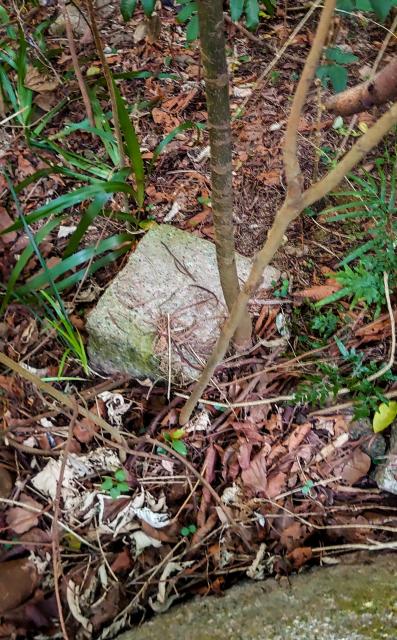
A granite marker stone was noticed while exploring the historic W.D. lot 32 boundary near King's Park.
The size and shape is quite equivalent to a boundary stone.
Hoping that more information can be identified from the library and Government Record search.
W.D.L. No.32 King's Park (HKGRS)
The corner of the lot boundary.
A Point marked as "E/F/P"…
A Point marked as "E/F/P" was identified on the print map of "Kowloon" 1:600 137-SW-12 (Ed 1922)" recently bought from the Survey and mapping Office, Hong Kong.
When using the hkmaps viewer (reference map 1922.1), the same "Point" can be identified and the coordinates approximate as follow.
Longitude: 114.17357 Latitude: 22.31160
Using the overlay function of hkmaps viewer, the current location of the "Point" was shown on the open street map.
For verification of location, the coordinate was input in the "WGS84 LATITUDE AND LONGITUDE" location search function of the Geoinfomap ( https://www.map.gov.hk/gm/ ).
The location comes close to the granite marker recently identified (Longitude 114.17355 Latitude 22.31158).
What is this "Point" denoted on the map 1922? Is it a boundary stone of any lot?
The coordinates of Point "E/F/P" in 1922, and one of the corner of WD Lot 32 boundary of 1947-1955 are compared with the coordinate of the granite marker being found near King's Park 2023.
Year Longitude Latitude
1922 114.17357 22.31160
1947 114.17365 22.31177
1950 114.17358 22.31162
1955 114.17359 22.31164
2023 114.17355 22.31158
Any chance of correlation?
Revisted the granite marker…
Revisted the granite marker on Jan 5 2024.
The pervious dense overgrown surrounding the marker has been largely cleared, probably after typhoon and raining season over the past few months. The buried side engravings can be seen partially.
A great surpise!
Is "PARK" there?
KING'S PARK BOUNDARY STONE
Curiousity solved!
My sincere thanks to all the help and support!
Location?
May I have location?
LAT 22.31161004 LNG 11…
LAT 22.31161004 LNG 11.17356714(by Historical Walk HK)
Good work on tracking down…
Good work on tracking down the stone and its history. I've made a Place for it at https://gwulo.com/node/60014
Re: King's Park Boundary Stone
For information.
At the corner of Chi Wo Street and Gascoigne Road, there used to be a King's Park boundary marker at the bottom of the old DGS wall facing Gascoigne Road near the former utility box and electricity pole. The marker could be seen prior to February 2009 and before the new wall was built. The old marker is different to the one recently found and no longer in existence. I have seen a photo of it at: https://www.uwants.com/viewthread.php?tid=7206167&extra=&page=5###
Unfortunately, work had already commenced on the construction of the new wall when the photo below was taken.