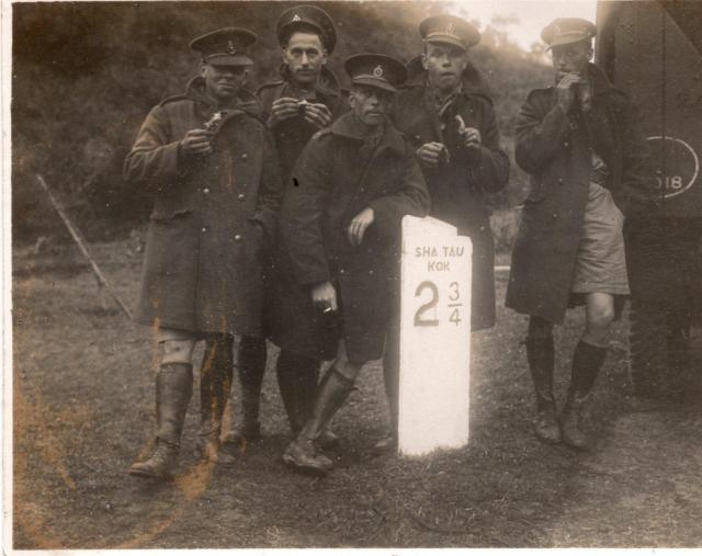
Looking at the 1952 map, it shows milestones along the Sha Tau Kok Road. On the map they are numbered by their distance in miles from Fanling: 1, 2, 3, etc. The last one at Sha Tau Kok is labelled "M.S. 6 3/4".
If start from Sha Tau Kok, that becomes point 0. Then MS 6 on the map is 3/4 miles from Sha Tau Kok, and MS 4 on the map is 2 3/4 miles from Sha Tau Kok.
Thank you for the comments on the two posts. These have been of considerable interest. However I note that on the listing for milestones by G Hibbert it states that Sha Tau Kok is a "closed area" Is there a reason for this.
Whilst I note you refer to a 1952 map do you think the photograph is possibly 1933 - 1936 and the road milestone would have been there at that time. Or are the milestones "more modern"
Looking at this road on the maps at http://www.hkmaps.hk/mapviewer.html, the first map that has the milestones marked on them is "Map 1945". That would mean the milestones were already in place before WW2, so they may well have been there in the 1933-36 period.
Can I say thank you for the added information concerning my photograph of the Marker stone. This has been helpful in clarifying the detail which is much appreciated.
I shall try and get the "uniforms" identified which will also help to pinpoint a date period.
After the removal of the Fanling to Sha Tau Kok KCR branch line in 1929, survey works and road improvements were made on the Sha Tau Kok Road in the 1930s. In 1931, the Sha Tau Kok Road was surveyed and comparisons made of the elevations of existing milestones. The P.W.D. Report for 1931 para. 320. refers.
The milestone marker looks relatively 'new'. The photo may date back to the 1930s.
On the left-hand edge of the photograph about centre, beneath what might be a bamboo pole, there are two parallel lines crossing from left to right at ground level which could be the steel tracks of the disused Fan Ling- Sha Tau Kok railway line. The track bed of this railway ran alongside the road at this spot.
Services on this line finished in April 1928 and R.J. Phillips in his book on KCR History records that the track was lifted “by June”. Coupled with a comment that the road marker looks quite new, if other viewers agree that the lines, I refer to are indeed railway track, this would likely date the photograph to about 1928.
Comments
Interesting Road Marker
Interesting road marker. Perhaps on the Fanling to Sha Tau Kok Road.
Au Ha ?
Looking at the 1952 map, it shows milestones along the Sha Tau Kok Road. On the map they are numbered by their distance in miles from Fanling: 1, 2, 3, etc. The last one at Sha Tau Kok is labelled "M.S. 6 3/4".
If start from Sha Tau Kok, that becomes point 0. Then MS 6 on the map is 3/4 miles from Sha Tau Kok, and MS 4 on the map is 2 3/4 miles from Sha Tau Kok.
MS 4 is marked near Au Ha. The map shows the road passing through a gap with slopes on either side, which matches the scene in the photo: https://gwulo.com/map-of-places#17/22.52594/114.19192/Map_by_ESRI-1952_All-Markers/100
The map shows seven milestones along the road. 1 to 6, and 6 3/4. Gerry Hibbert lists the first six as missing: https://gwulo.com/node/8603
Sha Tau Kok
Thank you for the comments on the two posts. These have been of considerable interest. However I note that on the listing for milestones by G Hibbert it states that Sha Tau Kok is a "closed area" Is there a reason for this.
Whilst I note you refer to a 1952 map do you think the photograph is possibly 1933 - 1936 and the road milestone would have been there at that time. Or are the milestones "more modern"
Regards
The closed area ran along the
The closed area ran along the border, which included Sha Tau Kok. There's more info about it at https://en.wikipedia.org/wiki/Frontier_Closed_Area
Looking at this road on the maps at http://www.hkmaps.hk/mapviewer.html, the first map that has the milestones marked on them is "Map 1945". That would mean the milestones were already in place before WW2, so they may well have been there in the 1933-36 period.
Border with China etc
Can I say thank you for the added information concerning my photograph of the Marker stone. This has been helpful in clarifying the detail which is much appreciated.
I shall try and get the "uniforms" identified which will also help to pinpoint a date period.
Regards
Re: Sha Tau Kok Road
After the removal of the Fanling to Sha Tau Kok KCR branch line in 1929, survey works and road improvements were made on the Sha Tau Kok Road in the 1930s. In 1931, the Sha Tau Kok Road was surveyed and comparisons made of the elevations of existing milestones. The P.W.D. Report for 1931 para. 320. refers.
The milestone marker looks relatively 'new'. The photo may date back to the 1930s.
Sha Tau Kok Road - Light railway line.
On the left-hand edge of the photograph about centre, beneath what might be a bamboo pole, there are two parallel lines crossing from left to right at ground level which could be the steel tracks of the disused Fan Ling- Sha Tau Kok railway line. The track bed of this railway ran alongside the road at this spot.
Services on this line finished in April 1928 and R.J. Phillips in his book on KCR History records that the track was lifted “by June”. Coupled with a comment that the road marker looks quite new, if other viewers agree that the lines, I refer to are indeed railway track, this would likely date the photograph to about 1928.