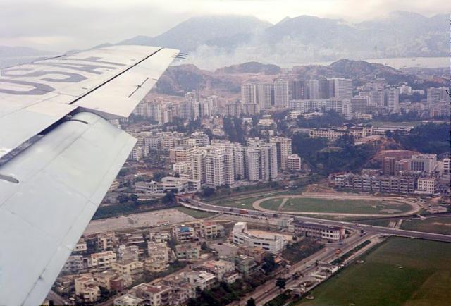
This should be the Tung Road junction with Boundary Street (vanishing left under the KCR Railway Bridge). The stadium should be the Muncipal Stadium (todays Mong Kok Stadium).
Source: This image came from Flickr, see https://flickr.com/photo.gne?id=42720909232
Update 2025-02-25: date set to c.1965 after comment below.
Date picture taken
1965 (year is approximate)
Gallery
Shows place(s)
Comments
Probably taken in mid-1960’s
Probably taken in mid-1960’s, circa 1965.
One handle is the block of buildings sandwiched by Flower Market Road and Prince Edward Road West (PERW), in the immediate south of (present-)Mong Kok Stadium. At the east end of that block, Kingly House and No. 3-5 Yuen Po Street, both completed in 1968, were absent in the photo.
No. 206-208 PERW, completed in mid-1966, were still cip, at about double the height of surrounding Tong Lau in the photo. In other aerial photos of LD in late 1964, the structure (if any) at that location was not significantly taller than the other Tong Lau, pushing the photo date to 1965 or after.
The time window from 1965 matches the appearance of (completion time): King’s Court (1965-q1), Mount Trio Court (1965-q1),
and that of the other buildings on the northwest part of Waterloo Hill AND in the west of King’s Court:
Man Kee Mansion (1966-q2) [not seen at this angle], Waterloo Heights Garden (1965-q4) [if existed, not full height yet], Cambridge Court (1965-q3) [cip at full height], Beauty Court (1965-q3) [cip at full height], Kerin Court (1964-q3) [looked completed].
Thus, the trailing limit of time window can be set at 1966-q2 (if by using No. 206-208 PERW and Man Kee Mansion), or 1965-q3 (if by using Beauty Court).