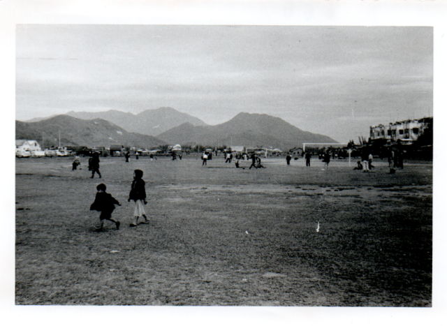
Have now obtained this photo, which belongs with the other two, previously uploaded, of children playing on a large football field. Mountains in distance are distinctive but I cannot identify them despite looking through several books on HK landscape, New Territories etc. The dark box-shaped object near the white building on far left could perhaps be a railway bridge. Light-coloured buildings on the right appear to be a row of houses.
Date picture taken
1950s
Shows place(s)
Comments
Robin's nest
The dipped hill centre screen mid background is Robin's Nest seen from roughly a SW direction, so I think its safe to say this is one of the camps in Fanling. The big mountain in the distance is Wutang mountain in Shenzhen. Most likely Gallipoli lines (now San Wai barracks).
Likely location
Thanks very much Phil, I'll try to find out more about this place. Cheers, Liz
Gallipoli Lines
Hi Liz
Actually the angle seems to line up fairly closely with the oval sports ground that can be seen on Google earth immediately behind San Wai (aka Kan Lung Wai) walled village.It's possible the sports ground has remained intact even after all these years.
There's a good chance someone who was based there will pop along at some point and be able to confirm.
Cheers
Phil
edit: you can see a very similar angle (though from a bit further west, I feel) of the background hills on the top picture on the following page relating to Kwanti racecourse: https://gwulo.com/media/15489
sports ground near San Wai
Hi Phil, I agree that the oval sports ground you've identified is a likely contender - thanks for spying that! There are several rectangular shapes next to the oval that could be where the huts once stood. They can be seen here: https://goo.gl/maps/W96tZLbLqUu. The line of sight from the end of this oval seems to be similar to that in the photo.
Another possibility is the smaller, square-ish field just on the other side of the existing rows of barracks buildings from the oval. I realise this is less likely because, if the photographer had stood at the bottom of this field, they would be looking in a different direction - by about 90 degrees. It's also less likely because the existing buildings look different and there are fewer of them (7 or 8 in the original photo, but only 5 in the Google view). However, I believe these buildings have replaced earlier ones at some point (see my comment on the other photo).
I'm also not sure about the white houses(?) on the far right of the photo, as I can't see anything similar on the current site. But, as you say, hopefully someone familiar with the place will volunteer some more information. I've noticed there's not much info on the barracks or camp and presumably that's because it's still in use by the military.
Regards, Liz
Playground in Fanling
Greetings. philk's finding is impressive. For interest, I played with Google photos to match the ridgelines, and estimate that the photographer was standing on the southwest side of the oval sports ground looking to the north-east. He/she likely has just arrived from the edge of town. The white buildings on the left would be on the current five square-ish field north of the track. I cannot explain about the buildings on the right. Regards, Peter
Re: Playground in Fanling
Hi There,
We need some older photos or maps for reference. We could not rule out the site had been revemped in the past few decades thus those newish barracks shown in up-to-date Google Maps may not be there yet.
The buildings on the right hand side is still a blur, difficult to identify. But with older maps we might be able to come up with something.
T
photos
if there is someone with some photoshop skills, I think this photo and the other one can be almost joined up to form a wide angle view of the whole area. Perhaps that was the photographer's intention?
Playground in Fanling
Greetings. See if this makes sense. The photographer took the photo of the young girl and her brother first. There are two separate ridgelines at left and mid photo, respectively. (please ignore the furthest/highest rdigeline in the photo) When we look closer the hill on the right, there seems to have a third ridgeline in front of it.
Then he/she walked up to the left to photograph the children pushing the baby carrige and the seven buildings. From where the white car is (see philk's link above), look up and we will see what appears to be a peak not visible on the first/this photo. That peak could be part of the third ridgeline, but I cannot rule out it is part of the left hill in the first photo. Regards, Peter
Peak
The peak you are talking about is all part of the ridge that runs along the north of the barracks. So it would be on the left of this photo. Hence why I think it might be possible to join the two pictures side by side.
edit: like this
Lines up nicely
That looks much better, thanks very much Phil. It's certainly a large, proper playing field, given the goalposts etc.
A few mysteries for me to solve, still:
1. what do the Chinese characters say on the huts to the left? (too fuzzy to read, and I can't read Chinese in any case I'm afraid)
2. are the buildings up on the slight rise to the right, residential homes?
3. who are the children in the photo? my guess is local children from the nearby village, but I could be wrong. It would be great if any Gwulo readers could identify anyone in the photo, although of course it was a long time ago.
old map of the area
Hi T, old maps of this area seem to be hard to come by, but it would be good to find one, yes. Old photos of San Wai camp from the 1950s seem to show mostly the rounded Nissen huts (rather than those in my old photos), but I'm not certain exactly where these were located in relation to the barracks. Regards, Liz
pic
no problem, Liz. But after doing it, I get the feeling there may be a little more missing between the two photos than previously thought. However, at least it gives a better impression of the area.
Playground in Fanling
Great job connecting the two photos together, Phil. The houses on the left and the ridgeline line up well, although not the ground impressions. Since the hills are close to the camera, their ridge lines move laterally relative to each other as the camera man walks either left or right. The two flat plateau look similar thus my initial thinking that they are one and the same.
The buildings on the right could be military living quarters, see San Wai in this 1952 map - https://gwulo.com/jubilee-buildings?a=1#16/22.5077/114.1516/Map_by_ESRI… Regards, Peter
Military Camp/Sports Field ?
If it is a military camp or army sports field, the site would appear under British Army installations (1950) as noted here The connection with the former Kwanti Racecourse has already been suggested. San Wai Camp from the 1950s can be viewed here . Not sure if the row of buildings are those in mid-left centre of the photo.
I think a moden day view of the ridgeline on the right can be seen here
1938 sketch of Kwanti Racecourse location near San Wai Camp
Available on the HKU Libraries website: http://digital.lib.hku.hk/hkimage/collections?PID=77209&search=san%20wa…;
The accompanying text says: "An outline sketch of the Kwanti Racecourse of the Fanling Hunt & Race Club. North of the racecourse is the San Waii Barracks, west is the San Wai Village".
Kwanti Racecourse, San Wai Barracks & San Wai Camp
If the 1938 sketch of the racecourse referred to above is correct, that should mean that the current San Wai Barracks are sitting on the former racecourse (more or less), whereas the San Wai Camp was actually across the river to the north. This would obviously mean that the Barracks were built sometime after the racecourse ceased operation. (Not sure if someone elsewhere on Gwulo has already noted this, apologies if so.)
San Wai camp
It looks like Moddsey's photo link does show the line of huts plus a big open space in front. So it looks like the original camp was significantly expanded at some point to include much of the land down to the Sha Tau Lok Rd. I guess Liz's pictures were taken before this happened and could explain why there appears to be many indicators of civilians in that area including the houses. Are there public records that might show when the camp was expanded?
Re: Photos of San Wai and Environs
The NT photos are dated circa 1948-1950. A photo from the same collection of San Wai and its environs.