Source: This image came from Flickr, see https://flickr.com/photo.gne?id=23783054718
Date picture taken
1967
Gallery
Shows place(s)
Source: This image came from Flickr, see https://flickr.com/photo.gne?id=23783054718
Comments
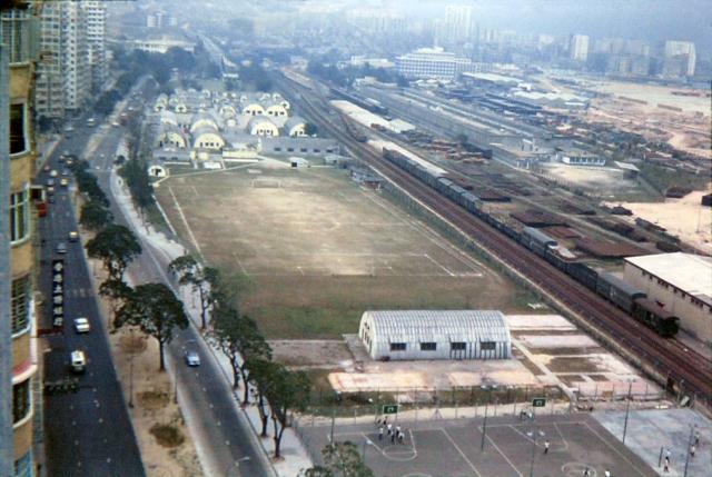
On the left, there was a bank
On the left, there was a bank. The sign reads 香港友聯銀行.(Union Bank of Hong Kong)
According to 1967 年香港年鑑, the address of the bank was 33-35 chatham road. Its location is at the chatham rd-hart ave junction at the union building (友聯大廈).
At the lower right corners there were two basketball courts for children and one that looks that a tennis court.
Here two pictures of those playgrounds. Also one can see the railroad tracks and some warehouses.
============================
==========================
==========================
Chatham Road Children's Playground and Rest Garden
In short, Chatham Road Playground. The recently posted photos were probably taken near the jiunction of Mody and Chatham Roads as Ocean View Court can be seen in your top photo.
Empress Hotel
I think the photos would've been taken from the Empress Hotel?
Chatham Road/Mody Road
I lived in Ocean View Court on the corner of Mody Road and Chatham Road in 1957, I think the play ground you mention had gone by then as I only remember the army barracks in front of the building on the other side of Chatham Road. I understand that the block of flats called Ocean View Court is still standing today. We lived on the 12th Floor
Ocean View Court
We have some photos of Ocean View Court at https://gwulo.com/node/9257/photos
Re: Marker Stone
Hi there,
I vaguely remember there used to be a small marker stone close to the Mody Road end on the lawn. But it disappeared about two decades ago, after the site was rebuilt.
It was about the same size of the one on Bonham Road.
T