David's excellent new mapping feature has spurred me into finishing a minor project which has lain in my bottom drawer unfinished for the best part of ten years.
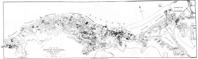
It is a sketch map of the City of Victoria dated as 'corrected to 1905'. It was published in the Hongkong section of the Directory & Chronicle of China, Japan, Corea etc etc. (1906 edition). The map featured has been recreated by digitally combining several separate microfilm-reader printer pages together. Some minor enhancement work has also been done, mainly the erasure of ink and reflection blotches which were notorious from early generation microfilm printers.
The map is broadly similar to GWULU's 1909 map but this a slightly earlier version, prepared by a different cartographer, which might provide some different features useful to forum members. It also covers as far east as Causeway Bay.
There is a coloured version of this map in the 1905 edition of the Directory & Chronicle. This edition of the Directory is freely available on line in pdf file format, from Google Books, having been scanned by the University of Michigan. Unfortunately the scanner (or person operating it) did not take into account folded pages so we end up viewing a photo-scan of the unfolded map. Highly irrigating ! Anyone have the time to go and have another go at reproducing the coloured map in full as well as very useful early maps of other Chinese cities and Treaty ports?
Comments
Can you please add the link
Can you please add the link here. I only found a 1907 Directory.
Searching Google Books
Hi
I am sorry but I have now mislaid the direct link but I previously downloaded and saved about ten complete years of the Chronicle & Directory of China, Japan, Corea etc etc. by searching Google Books. This advice I gave a friend some time ago probably still applies:
For a first start go to:
https://archive.org/details/googlebooks
In the Advanced Search box click enter ( All media types) , then
"Chronicle & Directory of China" and in the dates section fill in
dates between : 1870 :01:01 and 1945 : 01: 01
You should come up with at least 5 or 6 positive results first try. Slight variations in the title will produce other results. After 2 days of trying various options I was able to download free of charge 10 different years editions of the Chronicle. You then have to go through them port by port and city by city. It's a time consuming hobby.......... something which my fake antique gold watch collecting friend* will never understand!
(*note he's "been 'ad" several times)
Thanks for uploading this,
Thanks for uploading this, and well done for cleaning & reassembling the parts into a single image.
I've added a task to the to-do list to add it as a layer to the maps, as the extra coverage of Causeway Bay and Kennedy Town makes it a useful addition.
Regards, David
David , Thanks for the kind
David , Thanks for the kind comments. I am pleased that the map will be of sufficient clarity and resolution to be included in your excellent new map project. I have a couple more (for 1866 and and 1873), although the detail in the original microfilm prints are not of such good clarity (or containing as much detail) as the 1905 one I have just uploaded. Would you like me to spend some time cleaning these up and also adding them?