Stonecutters Island with Lion Rock in the background?
Looking for help to identify these photos my grandfather took when he was in Hong Kong with the British Army in the 1950s. I've carried out some research by looking at old photos but with limited success. The photos have also been shared with a number of Facebook forums. I'm really grateful for any help anyone can give as my goal is to build an album showing my grandfather's photos against the modern day photos of our time in Hong Kong.
Date picture taken
1950s
Gallery
Shows place(s)
Comments
Government houses next to the
Government houses next to the Argyle Street barracks? Waterloo Road?
breskvar
Osborn Barracks
with checkerboard hill at the back?
Interesting Photo
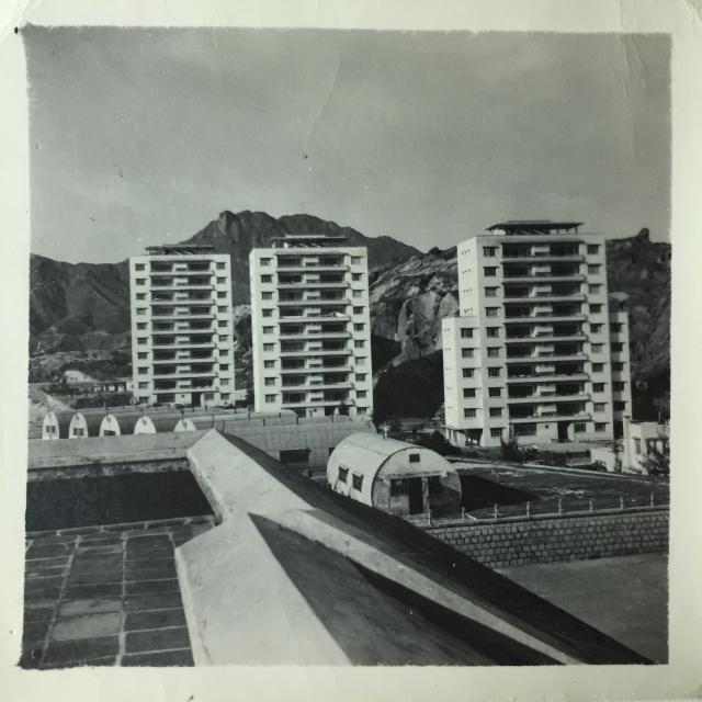
I think these 3 tower blocks belonged to the HSBC and being under the flight path at Kai Tak were subsequently knocked down for the construction of the single runway at Kai Tak. See here and here Stonecutters Island cannot be seen. Lion Rock is in the centre of photo.
HSBC flats
I think Moddsey is correct. So was this photo taken from the roof of La Salle as well? Was the nissen hut area part of a barracks or was this when the school was still being used as a military hospital?
HSBC's 3 towers
I am not questioning the decision to knock down these towers, as they did stand up like a menace. They were much farther away from the new runway's landing path compared to the 4-storey buildings in Kowloon City. Just curious. Regards, Peter
Re: HSBC Tower Blocks
From the aerial photo below, the nissen huts in the original photo appear to have been taken from La Salle College. The tall HSBC tower blocks would have been at the junction of College Road and Nga Tsin Wai Road. The aerial photo also shows the height difference between the HSBC tower blocks and the pre-war buildings in Kowloon City which I assume would have protruded into the arrival and departure paths of aircraft using the reclaimed runway at Kai Tak..
HSBC Tower Blocks
Thanks Moddsey, your explanation and this photo put places into proper perspective. Regards, Peter
Thank you!
Wow, I'm really impressed. Thanks folks.
La Salle College / 33rd General
Here is another view of the same nissen huts found of La Salle College playfield, as part of the 33rd General Military Hospital facilities.