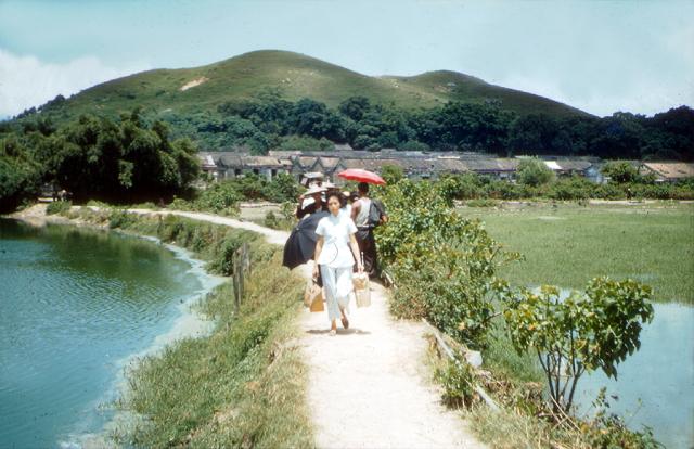
Well spotted. The outline of the hills in the background certainly matches very well with those just visible on the Street View image. How things have changed! In 1957/8 Yuen Long was still a smallish town with open countryside only a stone's throw from the central offset crossroads still identifiable on Google Earth. 65 years is a long time ago, but I have always remembered that this and other photographs of the rural scene were taken looking North from along that stretch of road between Yuen Long / Kam Tin / Sek Kong and possibly beyond. In most cases the photographs would be taken from the main road. The low rise buildings on your Street View are probably on the site of the rural village visible in the background of my photograph. With all the current construction work going on, it is probably impossible to stand on the same spot beside the main road as I did in 1957/8! Andrew
It's quite hard to match these old locations as you know, but I'm quite confident it's the right spot. I'd say the modern development is definitely not an improvement.
Apologies. Your street view location is good, and it shows a modern version of the village, devoid of any high rises. My photograph shows that I was standing only a hundred yards or so south of the village and not beside the main Kam Tin Road. Looking at the 1952 map there should be two fish(?) ponds on either side of the raised path - or are those on the photograph flooded paddy fields? If ponds, it might be that the other village just to the East of Tuen Tau Tsuen is another candidate? Regards Andrew
Hi Andrew - I think the deciding factor has to be the profile of the hill in the background. This coupled with a few other clues I found on the 1963 aerial imagery gives a good indication we have the correct location. The location I suggested matches the hill profile seen in your image, moving east or west changes the profile and loses the match. Also, if you look at the 1963 aerial imagery for that location you will notice it coincides with a curved path between two ponds. You can also spot the lighter coloured roofing of the buildings on the far right of your image. Also the vegetation growing in the pond on the right.
I'd say you were standing about 250 metres north of the main road when you took this imagei.e. about 2/3 of the distance between the village and main road.
Yes, you are quite correct. I should have consulted, as would usually be my normal practice, the excellent aerial photographs in the 1963 book. 65 year old memories can be a problem but I definitely used the local bus services to explore the New Territories. On one occasion I recall having an egg curry in a small restaurant on the North side of the main street in the centre of Yuen Long. Afterwards, at the eastern edge of the town there was a bus parking area on the south side of the road from where I would take a bus to Kam Tin and then on to Tai Po Market. If I had to kill some time before the next bus, I might easily have been tempted to cross the road and follow the path that led between the paddy fields and ponds. My photograph shows the 'pond' on the right to be shallower than the one on the left. So it was almost certainly a flooded paddy field as portrayed on the aerial image. Well done. Any chance of locating some more of those photographs? I see that while I have added a pin in the correct place for the photograph(s) of the two images looking cross a river bend towards the buffalo hide image, I have not updated the photographs adequately. I'll try to do that. Regards Andrew
Comments
Tung Tau Tsuen
I think this might be Tung Tau Tsuen - in Yuen Long old mkt area - just north of today's Yuen Long Tuen Ma Line (formerly West Rail) railway station.
Approximately the same view today.
Hi Phil,Well spotted. The…
Hi Phil,
Well spotted. The outline of the hills in the background certainly matches very well with those just visible on the Street View image. How things have changed! In 1957/8 Yuen Long was still a smallish town with open countryside only a stone's throw from the central offset crossroads still identifiable on Google Earth. 65 years is a long time ago, but I have always remembered that this and other photographs of the rural scene were taken looking North from along that stretch of road between Yuen Long / Kam Tin / Sek Kong and possibly beyond. In most cases the photographs would be taken from the main road. The low rise buildings on your Street View are probably on the site of the rural village visible in the background of my photograph. With all the current construction work going on, it is probably impossible to stand on the same spot beside the main road as I did in 1957/8! Andrew
NT
Hi Andrew
It's quite hard to match these old locations as you know, but I'm quite confident it's the right spot. I'd say the modern development is definitely not an improvement.
Phil
Hi Phil,Apologies. Your…
Hi Phil,
Apologies. Your street view location is good, and it shows a modern version of the village, devoid of any high rises. My photograph shows that I was standing only a hundred yards or so south of the village and not beside the main Kam Tin Road. Looking at the 1952 map there should be two fish(?) ponds on either side of the raised path - or are those on the photograph flooded paddy fields? If ponds, it might be that the other village just to the East of Tuen Tau Tsuen is another candidate? Regards Andrew
Village
Hi Andrew - I think the deciding factor has to be the profile of the hill in the background. This coupled with a few other clues I found on the 1963 aerial imagery gives a good indication we have the correct location. The location I suggested matches the hill profile seen in your image, moving east or west changes the profile and loses the match. Also, if you look at the 1963 aerial imagery for that location you will notice it coincides with a curved path between two ponds. You can also spot the lighter coloured roofing of the buildings on the far right of your image. Also the vegetation growing in the pond on the right.
I'd say you were standing about 250 metres north of the main road when you took this imagei.e. about 2/3 of the distance between the village and main road.
Edit: added image. X marks the spot.
Hi Phil.Yes, you are quite…
Hi Phil.
Yes, you are quite correct. I should have consulted, as would usually be my normal practice, the excellent aerial photographs in the 1963 book. 65 year old memories can be a problem but I definitely used the local bus services to explore the New Territories. On one occasion I recall having an egg curry in a small restaurant on the North side of the main street in the centre of Yuen Long. Afterwards, at the eastern edge of the town there was a bus parking area on the south side of the road from where I would take a bus to Kam Tin and then on to Tai Po Market. If I had to kill some time before the next bus, I might easily have been tempted to cross the road and follow the path that led between the paddy fields and ponds. My photograph shows the 'pond' on the right to be shallower than the one on the left. So it was almost certainly a flooded paddy field as portrayed on the aerial image. Well done. Any chance of locating some more of those photographs? I see that while I have added a pin in the correct place for the photograph(s) of the two images looking cross a river bend towards the buffalo hide image, I have not updated the photographs adequately. I'll try to do that. Regards Andrew