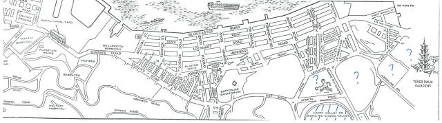
This is from a 1959 tourist map. On the bottom right corner, it shows the race course as 'Happy Valley On Wong Nai Chong Valley'. I have marked this in blue hatching.
I wonder if the truncated triangular area to the north of the race course (where the footballer is) was a playing field at the time?
Similarly, was the kidney shaped area to the east of the triangular area also a playing field?
Also, what was the extent / boundary of the Tiger Balm Gardens? Right up to Caroline Road or just around the area where the pagoda and trees are shown?
Any light shed on this would be very much appreciated!
Date picture taken
1959
Comments
Re: there are existing information of the question mark location
Hi there,
https://gwulo.com/node/8877
https://gwulo.com/media/19125
https://gwulo.com/node/13495
Thanks & Best Regards,
T
Hk tourist map 1959
where the footballer is shown... Was the site of the then HK Football Club.
Thank you very much T Ngan
Thank you very much T Ngan for the links!
Thank you very much Masang
Thank you very much Masang for the info!
The Tiger Balm Gardens weren
The Tiger Balm Gardens weren't located within the area this map shows, they were quite a distance off to the right. You can see their location at:
https://gwulo.com/node/2421
Regards, David
Thanks David, making a lot
Thanks David, making a lot more sense now!