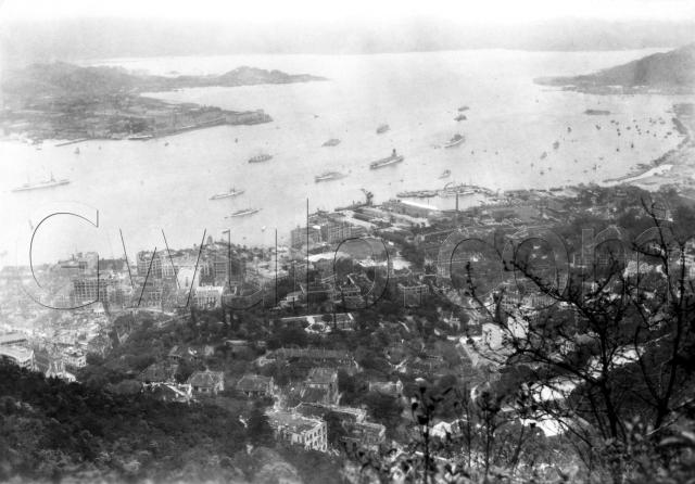
A couple of islands caught my eye in this photo. Up at 11 o'clock, in the distance beyond Hung Hom you can just see To Kwa Wan island. That is landlocked now, but I think some of the island's rocky hill is still visible in Hoi Sam Park, on the To Kwa Wan waterfront.
Over on the right of the photo at 2 o'clock is Kellett island, another that has since been joined to land by reclamation.
In fact if you look to the right of Kellett island, you'll see one of the big reclamation projects is underway. It pushed the shoreline from Johnston Road out to Gloucester Road, and in this photo it is nearly complete. There's just a small section to be filled in at the western end of the reclamation, near to the military land.
Follow the coastline along to the left, and you'll come to the Navy's dry-dock. Looking up from there, you can see there was an aircraft carrier in the harbour, HMS Hermes. I'm not sure if it helps date the photo, or if it was often in port? This page shows it was in the region for several years during the 1920s and 30s as part of the China fleet, but doesn't give details of when it was in Hong Kong.
This photo also shows the redevelopment of the Kingsclere site on Kennedy Road, something we've talked about before. If you look below the letters 'co' in the watermark, you can see two new-looking buildings where Kingsclere used to stand.
This is the second in a set of three photos taken at the same time. The first view looked in a more westerly direction, this is the middle photo, and there's another to come that looks east along the shore of the island.
Under the photo was the hand-written title "The Pearl River at Hongkong, China", which makes me think it was taken by a tourist, rather than a resident.
What else of interest can we see in this photo?
Reference: A32C