The posting of this photos was sparked by the Mok Residence at 73 Waterloo Road.
This photo shows a residential property with a large garden at the junction of Argyle and Waterloo Roads and appears to have been next to the Mok residence.
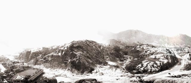
The photo was presumably taken from Homantin Hill looking across at what became Kadoorie Estates and the CLP Headquarters.
Any idea whose residence it was and when it was built/demolished.
rgds - Michael
Date picture taken
1930s
Shows place(s)
Comments
Another Mok residence
This was the home of Butterfield & Swire's comprador Mok Kon Sang's 6th wife. It is/was No. 79 Waterloo Road, Kowloon Inland Lot 2076. Today, Imperial Court, and part of Yee On Court occupies this space.
Mok Hing Kiu's family at No. 73 could reach their aunt at this mansion via Julia Avenue and a pathway to the back of her house.
I can't supply any dates, other than the date of 1931 as given by the Kadoorie Estate website for this photo. Mok Hing Kiu's family occupied their house at No. 73 between 1928 and 1936.
Comments copied from another copy of this photo
Diocesan Boy's School?
Submitted by lolau on Mon, 10/31/2011 - 16:53
With a large playground, would it be Diocesan Boy's School?
Kadoorie Hill
Submitted by fivestar on Tue, 11/01/2011 - 02:22
If the road on the right side of the photo below the hill leading to the hills in the background is Waterloo Road in the direction of the New territories, then the residence I am referring to is unlikely to be DBS as it should be located near the barren hill. Strange, I also do not see the railway bridge which is near DBS. I believe DBS in its current location was completed in 1926.
If one looks at Waterloo Road at the bottom, it does not appear to have been completed?
Look at the 1924 Kowloon Map quadrant4. it shows the hill and "path". It does not show any developments in the area.
Perhaps this photo is earlier than 1924?
Kadoorie Hill
Submitted by bunce on Tue, 11/01/2011 - 03:49
Hi - Agree with Fivestar that the road on the right is Waterloo Road (today it heads literally into Lion Rock, which is visible on the top right).
The road running across the foreground would therefore be today's Argyle Street. The residence is probably a private mansion, certainly not DBS which is on the other side of Argyle St. In other words the photo is showing the southern slope of Kadoorie Hill while DBS, being located mostly on its north side, is hidden from view.
As such, the railway bridge is also hidden behind this view of Kadoorie Hill. Comparing to today’s scenery, perhaps try to picture the CLP Power HQ at the bottom right hand bend into Waterloo Road.
Kadoorie Hill
Submitted by fivestar on Tue, 11/01/2011 - 04:57
Bunce, looks like we are on the right track. The building in question would today be in the triangle, Argyle Street, Victory Avenue and Waterloo Road. if one looks at the history section on the following url, one can see the residence in the background in the photo of a model of the planned Kadoorie Estate.
http://www.thekadoorieestate.com/
CLP
Submitted by breskvar on Tue, 11/01/2011 - 17:49
The white bit of flat land in the middle on the foreground should be where the CLP building is built later on. I agree the railway bridge is not in view because it crosses Waterloo Road on the left of this photo.
Kadoorie Hill
Submitted by fivestar on Wed, 11/02/2011 - 00:32
The section of Waterloo Road through Mongkok to Kowloon Tong was constructed in 1922. Given that the photo indicates that the road was still under construction, perhaps 1922 is a better date for this photo.