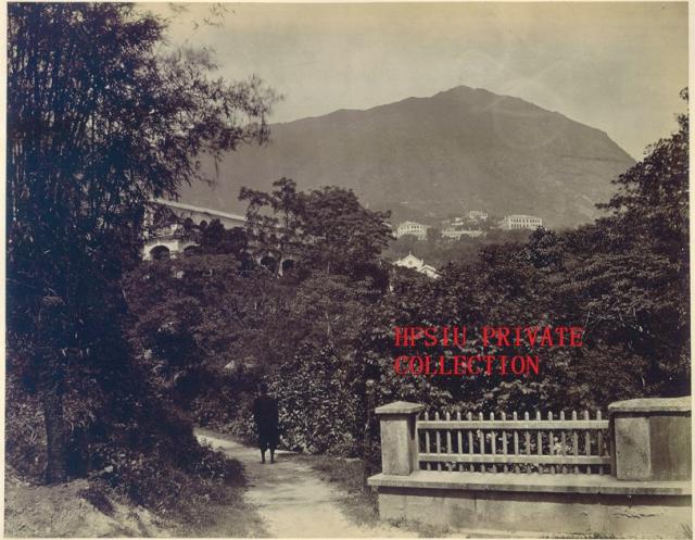
This photo was taken much further away than the Botanical Gardens. I believe more to the east. The building lower middle appears to be St. Joseph's Church
I'll second St Joseph's Church as the identity of that white gable.
I'd put the photographer somewhere within the military cantonment, probably up above the Murray Barracks. It looks as though there's a bridge in the lower right corner - maybe crossing over the Albany nullah?
Today's Cotton Tree Drive runs on top of the old Albany Nullah, so I'm guessing the photographer stood near where the pedestrian footbridge over Cotton Tree Drive stands today - point A on the map.
The large building center right became Canossa Hospital. The "C" marker identifies it correctly. With St. Joseph's identified, you should be able to triangulate to get the location of the photographer.
The distinctive building in the background centre is also a good clue. It's two stories with a large terrace on the first floor roof, with a sloping roof on the second floor. It's presumably a military building. You can see it in this 1900 photo on the govt website - roughly centre and mostly surrounded by trees. The location David pinpointed seems roughly right. Anyone able to identify the building any further?
this shot from google here shows we're roughly in the right place - St Joseph's is directly behind the Helena May building. Looks like the photographer was standing to the northeast of here
This map shows two bridges above Murray Barracks. One bridge is at the end of the blue-coloured section of the nullah (I think that's the one in the photo), and one is just below the 'd' of 'Cathedral'.
You can see two buildings on the hill above the Murray Barracks. The western building is marked 'Livery Stables'. I don't think it's that, since it looks as though it had a wider access road leading to it, as the name would suggest.
The eastern building is marked 'Racket Ct.', so maybe that's what we see in the old photo?
Comments
Interesting Photo
This photo was taken much further away than the Botanical Gardens. I believe more to the east. The building lower middle appears to be St. Joseph's Church
re: interesting photo
I'll second St Joseph's Church as the identity of that white gable.
I'd put the photographer somewhere within the military cantonment, probably up above the Murray Barracks. It looks as though there's a bridge in the lower right corner - maybe crossing over the Albany nullah?
I'm not sure whether the
I'm not sure whether the photographer was when he took this photo. Could you please mark it on the map?
Thanks
HF
Photographer's location
Today's Cotton Tree Drive runs on top of the old Albany Nullah, so I'm guessing the photographer stood near where the pedestrian footbridge over Cotton Tree Drive stands today - point A on the map.
[gmap markers=letters::22.277836206397495,114.16094183921814 + 22.277280237433338,114.1579806804657 + 22.2773608199969,114.15395200252533 |align=Center |zoom=16 |center=22.277540682733903,114.15717601776123 |width=400px |height=400px |control=Small |type=Map]
That seems to line up with the other landmarks in the photo:
Canossa hospital site
The large building center right became Canossa Hospital. The "C" marker identifies it correctly.
With St. Joseph's identified, you should be able to triangulate to get the location of the photographer.
re: mystery photo
The distinctive building in the background centre is also a good clue. It's two stories with a large terrace on the first floor roof, with a sloping roof on the second floor. It's presumably a military building. You can see it in this 1900 photo on the govt website - roughly centre and mostly surrounded by trees. The location David pinpointed seems roughly right. Anyone able to identify the building any further?
http://hkclweb.hkpl.gov.hk/hkclr2/object?svc=objrtv&src=CM&itemid=L0XIH2ERY1G5YU68&pid=1&mime=image/jpeg
re: mystery photo
this shot from google here shows we're roughly in the right place - St Joseph's is directly behind the Helena May building. Looks like the photographer was standing to the northeast of here
http://maps.google.co.uk/maps?hl=en&q=hong+kong&ie=UTF8&hq=&hnear=Hong+Kong&gl=uk&ei=6tg6TOKcGYHBce2tyeEI&ved=0CCkQ8gEwAA&ll=22.277754,114.160534&spn=0,0.004812&t=h&z=18&layer=c&cbll=22.277721,114.160449&panoid=o4qEoPzeA2CIQa2obBt_2g&cbp=12,261.26,,2,-5.15
re: Mystery Photo
Here's an 1880 map of the area:
This map shows two bridges above Murray Barracks. One bridge is at the end of the blue-coloured section of the nullah (I think that's the one in the photo), and one is just below the 'd' of 'Cathedral'.
You can see two buildings on the hill above the Murray Barracks. The western building is marked 'Livery Stables'. I don't think it's that, since it looks as though it had a wider access road leading to it, as the name would suggest.
The eastern building is marked 'Racket Ct.', so maybe that's what we see in the old photo?