There's a small building, several concrete structures, and many trenches. Does anyone know who built them, and what for?
Phil started off the investigation with this message:
I found a picture on Google Earth the other day of a pillbox(?) on Kei Lun Shan near Fanling. Not sure if its Japanese or Allied? http://www.panoramio.com/photo/22481156
I hadn't seen that pillbox before - very interesting! It looks quite similar to this one at Luk Keng: https://gwulo.com/node/1804#comment-7828
The checking a map of the area, it seemed this could be the western equivalent of the pillboxes at Luk Keng. That would make it a Japanese site, overlooking the coast by Lok Ma Chau, like Luk Keng looks over Starling Inlet.
A couple of weeks ago we went there for a look around. I'll post up the photos later, but here are Phil's notes first.
In a follow-up e-mail he writes:
Been doing some rudimentary digging and the mainland Defence Ruins book has a map of the area from 1936 on page 111. Route 15 goes quite close but not close enough. Anyway, it shows the hill as Haddon Hill and a quick search reveals a little tidbit of info from the Royal Navy website:
Tuesday, 26 September 1950
FAA, 807 Squadron, Theseus, aircraft carrier, Korean War, flying Sea Fury, carrying out ground attack exercise against British Army motor transport on hill in New Territories, Hong Kong, starboard wing hit Haddon Hill across the valley
GREEN, Allen T, Lieutenant (P), killed
Also, if you look on page 93 there is a photo of a hut that is similar (in fact exactly the same) to the one we saw. The text underneath says it is a Tan Yeuk Fu - an ammo shed.
I can't translate the text exactly but it seems as though the red bricks may be part of the original structure.
So we think the small building was built by the British. But it still seems a bit strange, as when the Japanese invaded the British forces didn't hang around in the northern New Territories, so why were they building there? And why are there so many trenches at the top of the hill -or did they come later and were dug by the Japanese?
Does anyone know the history behind this site?
Regards, David
Photos that show this Place
Comments
Military buidings on Ki Lun Shan
Hi,
I think these are part of the British Army's response to the presence of the PLA at the border from about 1950.
There are several similar huts up the "Birdly Jeep Track" on Cloudy Hill, south of Fanling. "Defensive positions" I should think, but I doubt if they would have held up the PLA for very long.
re: Military relics at Kei Lun Shan
Hi John,
Yes, c.1950's is another possibility. If you have any more information to back up that idea, please let us know.
Re the PLA, one of Fred Evans' comments was that their role in tanks along the border in the 1950s was just to cause enough delay that the VIPs could get away from Hong Kong. They weren't expecting to hold back any attack indefinitely.
Regards, David
Map of the visit
[gmap overlay=kml:https://gwulo.com/sites/gwulo.com/files/kml/gwulo-ki-lun-shan3.kmz |zoom=15 |center=22.49602399739424,114.09250259399414 |width=490px |height=350px |control=Small |type=Hybrid]
From the start to the small building
We took a taxi to the start - marker A on the map. It's where the road reaches the top of a small pass between hills to the north and south. If you've got the 'NW New Territories' countryside map, the path is clearly marked.
Here's where we got out. We walked up through the small gate on the right:
Then along and through a second gate:
If you zoom in to marker B, you can see that the path follows a track up the hillside. Here's part of it:
It's not paved, but still, someone went to the work of digging a track, so I guess there were vehicles moving up and down here at some point.
Here's the view of the small building Phil had spotted (marker C).
The door was open, so we went in for a look.
The quality of the construction is much higher than the Japanese Pillboxes at Luk Keng, so we gave up on that line of thought. eg Here's the view of the ventilation shaft in the ceiling. You can see there's a cast-iron pipe inside.
Up on the roof, the pipe runs some distance away before turning up, and is encased in concrete along its length.
Achoo!!
yeah, sorry about that. I was on my 4th cold of the year (currently on my 7th).
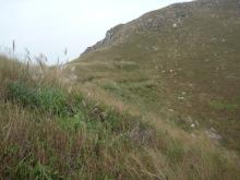
Trenches at Ki Lun Shan
After leaving the building we carried on up to the ridge that runs up to the main peak. The next thing we noticed were trenches. I've marked them with 'T' on the map. The number and locations aren't exact, but roughly they were:
A strange thing about them was the number of different styles. Most were U-shaped, dug roughly into the rock. (They must have been hard work - the soil is very thin, and each one is cut several feet deep into the rock). Here's an example:
There were also T-shaped, and simple straight trenches. Then some had had a rough cement finish applied to the walls:
And there was even this deluxe model, at the end of the ridge leading north:
The easiest way to find them is to look for a change in vegetation. We were there in November, a dry time of year, which made the dark green of the plants growing in and around the trenches really stand out:
Clearing for a building?
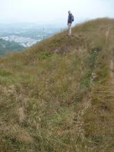
As you walk along the flat ridge, before climbing up to the summit, you can see there was a track cut into the north-east side of the ridge. If you assume that trouble was expected from the south-west, you could use this track to move along the ridge in shelter.
At the end of the track, roughly where the ridge starts sloping up again to the summit, there is a much larger rectanglular flat area cut into the hillside. It's marked as point D on the map, and is roughly in the centre of this photo.
Here's a view looking down on it from the other side:
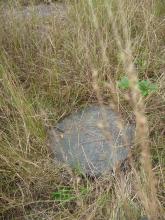
We noticed a couple of patches of concrete:
What used to be here? A wooden hut, maybe?
Dug-outs & trench near summit
We wlked up the ridge to the trig point at the summit. From the summit, walk a short distance to the west. There's a gentle slope for a little way, then the sides fall away more steeply.
Just at the end of the slope, point 'E' on the map, are three large, squarish pits. the two nearest the summit are linked by a trench that runs north-south across the ridge.
The soil here is very thin, so they've all been cut into rock. It seems like a lot more digging than you'd do in a training exercise. Take a look and see what you think:
Military Relics at Ki Lun Shan
Gentlemen,
Some of The trenches were built by the first battalion Northumberland Fusiliers. I know because I helped dig them. The Northumberland Fusiliers left Korea in 1951 and we arrived in Hong Kong in the autumn of that year.. We were stationed at the Norwegian Farm camp which stood at the foot of Haddon Hill near Fan Ling. The trenches were designed to protect the new territories from communist China. We also erected barbed wire entanglements.
Re: Military Relics at Ki Lun Shan
Hi Yorkie,
Thank you for the information! What was life like in the camp in 1951? What was the plan to deter Chinese Communist forces if they cross the boundary? I believe there was a division of British army troops in Hong Kong in 1949, but some had been sent to Korea by 1951.
re: Military Relics at Ki Lun Shan
Yorkie, thanks very much for clearing up the story behind these trenches. I've been hoping we'd hear from someone with first-hand knowledge.
If go back to the top of the page then scroll down, the first video you see shows a small brick & concrete building. Any chance you know anything about when it was built, and what it was used for?
There are more trenches over on Ho Hok Shan, and piles of barbed wire are still visible there (see https://gwulo.com/node/9503).
I've also made a page for the Norwegian Farm Camp. (See https://gwulo.com/node/13992) Any more stories about life in Hong Kong in the 1950s welcome!
Regards, David