It's Kwong Fuk bridge over the Lam Tsuen river. Yes, Pat Sin Leng in the background. The road on the right is Pak Sing Street.
Well spotted.
At a guess, I would say Fred took this from the train as it went over the railway bridge.
MrB - on a side note, the zoom function allows to see a bit more detail of the bridge and the concrete sides. Do you remember the block with the name and date (see below)? The current concrete wall structure looks like it could have been created using the old blocks we can see above, as we suspected at the time. Shame it's not in greater detail.
Fred was here at the end of the 1950's, so from the '1957' inscription on the stone above, he'd have photographed the bridge just a year or two after it was finished. (his original photos are a lot sharper, unfortunately all I have are the copies I took with my little digital camera).
The 1957 version of the bridge was still there in this 1983 photo, but the latest version of the bridge looks like this.
In 1896, the residents of Tai Po built Kwong Fuk Bridge to link Tai Po Old Market and Tai Wo Market.
I wonder if it's that 1896 bridge shown in your father-in-law's photo? I think the New Territories bridges were destroyed in 1941 by the retreating British forces, so it's probably different.
Although the bridge looks different between Fred's photo and your father-in-law's, the rest of the buildings look very similar. The end of the two-storey building we can see on the right of Fred's photo is clear to see (and much whiter!) in your father-in-law's.
Comments
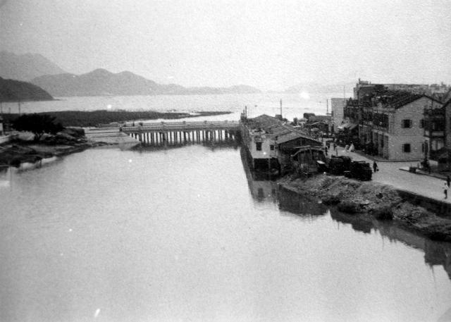
Where was this photo taken?
Any ideas? I'm wondering if it could be Tai Po, with Pat Sin Leng in the distance on the left?
Tai Po
It's Kwong Fuk bridge over the Lam Tsuen river. Yes, Pat Sin Leng in the background. The road on the right is Pak Sing Street.
Well spotted.
At a guess, I would say Fred took this from the train as it went over the railway bridge.
MrB - on a side note, the zoom function allows to see a bit more detail of the bridge and the concrete sides. Do you remember the block with the name and date (see below)? The current concrete wall structure looks like it could have been created using the old blocks we can see above, as we suspected at the time. Shame it's not in greater detail.
Kwong Fuk Bridge
Phil, thanks for confirming this.
Fred was here at the end of the 1950's, so from the '1957' inscription on the stone above, he'd have photographed the bridge just a year or two after it was finished. (his original photos are a lot sharper, unfortunately all I have are the copies I took with my little digital camera).
The 1957 version of the bridge was still there in this 1983 photo, but the latest version of the bridge looks like this.
According to 'Traditions & heritage in Tai Po', the first bridge was built in 1896:
In 1896, the residents of Tai Po built Kwong Fuk Bridge to
link Tai Po Old Market and Tai Wo Market.
I wonder if it's that 1896 bridge shown in your father-in-law's photo? I think the New Territories bridges were destroyed in 1941 by the retreating British forces, so it's probably different.
Although the bridge looks different between Fred's photo and your father-in-law's, the rest of the buildings look very similar. The end of the two-storey building we can see on the right of Fred's photo is clear to see (and much whiter!) in your father-in-law's.
More old photos of Tai Po here.