View the original, larger copy of this image at the UWM website: http://collections.lib.uwm.edu/u?/agsphoto,4140
Date picture taken
1940s
Gallery
Shows place(s)
View the original, larger copy of this image at the UWM website: http://collections.lib.uwm.edu/u?/agsphoto,4140
Comments
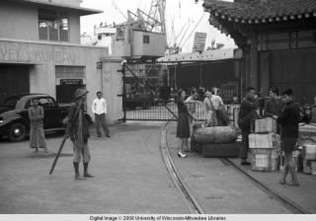
Aerial View of Entrance to Kowloon Wharf
From the other side...
This is a shot from The World of Suzie Wong - when Lomax walks from the wharf to the Star Ferry. The scene looks to be on the opposite side of the gate to the Foreman photo - the Chinese roofed building seen in the Foreman photo can be seen above the guy's head on the left, and I believe the other building (with Travel Bureau written on it in the Foreman shot) is the one centre picture here.
Those railway tracks
When I was looking for photos of the KCR terminus, one of the photos that stuck in my mind showed it shortly before construction finished. There was a length of railway track running along in front of the building (the side facing Star House), apparently in the way of pedestrians and road traffic - rickshaw pullers must have hated it.
The other odd thing about the photo was that the tracks just finished in the middle of the road - I couldn't think what they were meant for.
Then seeing the Forman photo, clarified by the aerial shot above, it's clear the track extended the main KCR line up along the wharves. A 1949 map shows it ran up along the shoreline, then turned out along a short pier at Navy Street. That's about where the China Hong Kong City pier is today.
I've yet to see any photo showing trains running along it, so I wonder if the tracks were ever used much?
Re: those railway tracks
Those 'railway tracks' were actually tracks for wheeled wagons that were used on public roads by the Kowloon Wharf and Godown Co. Ltd (KWGC) and pre-dated the Kowloon Canton Railway (KCR).
On 25 OCT 1897, the Kowloon Tramways Ordinance was passed allowing the KWGC the right to construct 'tramlines' on a guage not exceeding 2 ft in width on certain public roads in TST to facilitate the more rapid unloading of cargo from vessels that made use of the wharves at Kowloon. The wagons were pulled by labourers. I have not seen photos of other forms of conveyance. These were the days before motorised transport.
At the time. the KWGC owned substantial marine lots and godowns in TST. The first Star Ferry Pier at Kowloon Point was also located within the KWGC. The 'tramlines' were constructed on Canton Rd (formerly Macdonnell Rd), Haiphong Rd (Elgin Rd), Peking Rd (Chater Rd) and the Praya between Salisbury Rd and the Naval Dockyard (Torpedo Range).
As time went on, the KWGC relinquished their coastal lots for the construction of a 'new' Star Ferry Pier and KCR Kowloon terminus and railway. I am not sure when the 'tramlines' on public roads became disused
I have recently posted a few photos of the 'tramlines'.
Railway tracks or 'tramlines' ?
I still think the tracks shown in the Forman photo are railway tracks, not the tramlines you've described. You mention that the ordinance limited the tramlines to 'a gauge not exceeding 2 ft in width'. The tramlines in the old photo you sent show they fit within that limit.
But the tracks in the Forman photo are much wider apart.
Also the photos that you sent from Flickr [1, 2] show other sections of the railway track that linked the section shown in the Forman photos with the main KCRC tracks by the terminus building.
I hadn't heard of these tramlines before. Thanks for sharing the notes & photos.
RE: Railway tracks or 'tramlines' ?
Noted. May have to look up the KCR archive for confirmation.
RE: Railway tracks or 'tramlines' ?
Found these snippets of information. This may be the answer to the question.
The KCR (British Section) was opened on 1 OCT 1910. Pending the opening of the railway through to Canton, a portion of one of the godowns belonging to the KWGC was rented and converted into a Passenger Station and the Railway was laid down on Salisbury Road. I assume these are tracks as shown in the Forman photo.
In 1914, the platforms for the new Terminus Station were opened for traffic. The tracks were removed from Salisbury Road and the portion formerly used by the Railway were handed over to the Public Works Dept.
The KCR Kowloon Terminus was opened to the public on 28 MAR 1916.
1915 Hong Kong Map
This map shows the railway terminating at the Kowloon Wharf and Godown Co. Ltd.
I think the KCR line that was mentioned extending along the wharves to Navy St would be the 'tramlines' referred to in my previous posting.
RE: Railway tracks or 'tramlines' ?
Following up on the KCR archive.
In 1924, a siding was laid from Kowloon Station across the circulating area in front to connect with the KWGC premises. The siding, which was 273 ft long to the Company's boundary was laid in concretre with 2 guard rails. An agreement was entered with the Company regarding its cost and use.
In 1934, arrangements were made for bulk cargo destined for Canton to be loaded directly onto railway wagons at the KWGC siding, under Customs supervision.
re: railway tracks
A couple more photos to add to the story.
The KCR (British Section) was opened on 1 OCT 1910. Pending the opening of the railway through to Canton, a portion of one of the godowns belonging to the KWGC was rented and converted into a Passenger Station and the Railway was laid down on Salisbury Road.
This photo is dated 1914. Its caption is confusing, saying both that it is a "photograph of the Terminus shortly after completion", and that the "Terminus building (not seen in the photograph) at the time had not yet been completed". But I note the stone buildings just past the carriages. I wonder if these could have been the godown used as the temporary station?
But this photo, also dated 1914, shows tracks already laid past the terminus, and pointing towards the wharves. Could they be the tracks that ran to the temporary station? Or the start of the siding described above as reaching the KWGC premises in 1924?
Your KCR archives are turning up some good information. Is it available online?
Re: Railway Tracks & KCR TST Temporary Stations
Been following-up on a few unanswered questions and trying to piece a few items together.
The KCR (British Section) was opened on 1 OCT 1910. Pending the opening of the railway through to Canton, a portion of one of the godowns belonging to the KWGC was rented and converted into a Passenger Station and the Railway was laid down on Salisbury Road.
The photo below from the KCR archive shows the inauguration of the KCR line (British Section) from TST in 1910 and the temporary passenger station that was rented from the KWGC:
http://www.kcrc.com/en/about/popup_photo4.html
The railway would appear to be a fairly straight line of track that ran west to the Kowloon waterfront across Salisbury Road with its termination point seen in this photo, The Godowns were demolished in 1911 to make way for the construction of a permanent station and clocktower. The head offices of the railway was transferred to a temporary building, however the location is not specified. The KCR archive does not say whether or not the temporary passenger station was demolished as well.
By 1914, the building of the TST KCR Station had reached the first-floor level and as mentioned previously the platforms of the new Terminal Station was opened for traffic and the tracks on Salisbury Road removed.
As you say, This photo 's caption of 1914 is misleading. I think it was meant to show the tracks that originatied from the station's newly-built platforms. The buildings on the left may have been used as temporary offices.
1n 1916, the Kowloon Terminal Station was opened and the temporary offices and station were demolished and the large area in front of the Terminal kerbed and surfaced.
Getting back to the Forman photo. It shows a railway siding and not a remnant of the old tramline belonging to the KWGC as I had first thought, leading to the main KWGC gate.
The curved siding that is seen was built in 1934 from the Station across Salisbury Road and the circulating area to connect with the KWGC premises.
1930s curved siding leading to the KWGC prmises
1947 KCR Railway Siding to KWGC
The blow-up map shows the KCR Railway siding across the circulating area at Kowloon Star Ferry terminating just past the main entrance to the KWGC and linking up with the 'tramlines' at the Wharf.
Re: Railway Siding to Kowloon Wharves
Correction to the 1934 date.
1913 Hong Kong and Kowloon Wharf and Godown Co. Ltd Annual Report See here (scroll to page 5)
"The acquisiton of this land (Police Basin) rounds off our property and gives room for a fourth pier, whilst the location of the railway terminus at our gates, must enhance the value of our land and has facilitated the railway siding into our premises."