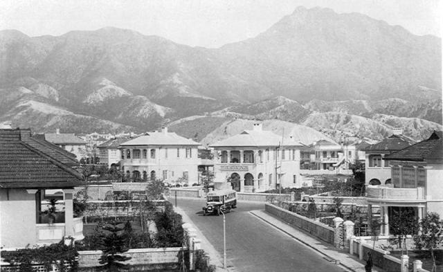
From the direction of the lion rock mountain and the coordinates of the road. It seems to be the current Essex & Cumberland road. The house with the black roof top( second on the right) is still there though.
Greetings. In the main/top photo, the view along Cumberland Road aims at somewhere between Lion Rock and Beacon Hill, which matches well from looking at the 1952 contour map and 1956 street map. Though not a technical point, this area is how I remember when I rode my bicycle here in the 1950s.
At Cumberland and south of Essex, the road is more aiming to the north-northeast hence closer towards Lion Rock. The 1956 map shows a triangular shape garden at this junction, and there was no garden at Rutland-Cumberland. Regards, Peter
Dear Moddsey, I'm looking for an image to illustrate a commercial project I'm working on – a story to be published in our magazine (print and online), which will also be issued in the form of a commercial booklet. The images will be used to illustrate the original garden-city character of Kowloon Tong. Would you be able to help me obtain permission to use the photographs? Naturally we will credit them appropriately. Thanks!
Hi, if you are referring to the main photo, mine is a scanned copy of an original photo. I do not hold the original photo and am not aware of its source. It came in a batch of photographs that showed scenes of Hong Kong from the 1930s. That said, the photograph does come up for sale at auction sites that sell old Hong Kong photos. Hope that helps for the fruition of your project. Thank you for writing in.
Comments
Amazing photos
What is the source of this photo?
Which road?
Which road is it in the picture?
Re: Which Road?
Hi there,
Based on the sharp turn and the skyline it is likely the junction of Cumberland Road and Rutland Quadrant.
Best Regards,
T
Kowloon Tong
I was walking around KT the other day and saw that there are still some of the original houses around.
Edit: One of the houses seen above (immediately behind the bus) is still there, albeit with the upper balcony blocked in.
Essex road & Cumberland Road ?
From the direction of the lion rock mountain and the coordinates of the road. It seems to be the current Essex & Cumberland road. The house with the black roof top( second on the right) is still there though.
Cumberland Road - View to the North
Greetings. In the main/top photo, the view along Cumberland Road aims at somewhere between Lion Rock and Beacon Hill, which matches well from looking at the 1952 contour map and 1956 street map. Though not a technical point, this area is how I remember when I rode my bicycle here in the 1950s.
At Cumberland and south of Essex, the road is more aiming to the north-northeast hence closer towards Lion Rock. The 1956 map shows a triangular shape garden at this junction, and there was no garden at Rutland-Cumberland. Regards, Peter
Rutland Quadrant
It's definitely Rutland Quadrant and not Essex Crescent
Request to use your photos
Dear Moddsey, I'm looking for an image to illustrate a commercial project I'm working on – a story to be published in our magazine (print and online), which will also be issued in the form of a commercial booklet. The images will be used to illustrate the original garden-city character of Kowloon Tong. Would you be able to help me obtain permission to use the photographs? Naturally we will credit them appropriately. Thanks!
Source of Photo
Hi, if you are referring to the main photo, mine is a scanned copy of an original photo. I do not hold the original photo and am not aware of its source. It came in a batch of photographs that showed scenes of Hong Kong from the 1930s. That said, the photograph does come up for sale at auction sites that sell old Hong Kong photos. Hope that helps for the fruition of your project. Thank you for writing in.
Thank you very much
Dear Moddsey - Well noted. Thank you very much for letting me know. Have a wonderful 2026!!