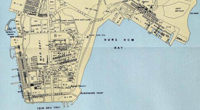
The complete 1914 Kowloon map (corrected) appears in the 1915 Directory & Chronicle This map is an update of the 1910 map of the Kowloon Peninsula at https://www.hkmaps.hk/viewer.html
Date picture taken
1914
Gallery
The complete 1914 Kowloon map (corrected) appears in the 1915 Directory & Chronicle This map is an update of the 1910 map of the Kowloon Peninsula at https://www.hkmaps.hk/viewer.html
Comments
Re: 1914 map
Interesting to see a Kowloon map from 1914. However, I'm not convinced about it's reliability. The buildings on Elgin/Haiphong Road are not given correctly. The 1910 map mentioned was also produced for the Directory&Chronicle, and also this one is incorrect regarding the houses mentioned above. On the 1904 map on Gwulo, all houses appear. The 1914 map possibly reflects the situation of c.1900 regarding theses houses.
Despite this, I think the map is valuable regarding streets and lot numbers.
Re: 1914 Map
Yes, the map is not totally reliable in terms of detail and accuracy and should only be used for reference as it has been reproduced by the Hong Kong Daily Press from a previous version. The same applies to other maps viewed in the Directory & Chronicle.
As a reference map, it is useful as it shows the original KCR train tracks along Salisbury Road, the temporary "Kowloon Station" and former extensions of Canton Road and Nathan Road to the waterfront.