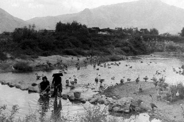
This photograph of a 'free range' goose farm was taken by an unknown member of the 367 Association in the late 1950s. It was almost certainly located in the New Territories, possibly to the East of Yuen Long but can anyone identify a more precise location?
Date picture taken
1950s
Gallery
Shows place(s)
Comments
Re: May be somewhere in Shek Kong\Kam Tin\Pat Heung area
Hi Andrew,
I suspect the hill in the middle is Kwun Yam Shan (Where the Kadoorie Farm is situated today) with Tai Mo Shan at the back. The foreground may be a natural river in the area.
If that is the case, it make sense as it is close to the barracks.
T
Sek Kong Camp
Sek Kong Camp in relation to Kwun Yam Shan.
Kwan Yam Shan.
Know as Doris Days nipple during my time in Sek Kong 1957-58.
Thank you Thomas, Moddsey…
Thank you Thomas, Moddsey and Bryan,
You all seem to agree about the likely location. My initial wild guess was that the photograph had been taken looking to the North but, with Tai Mo Shan in the background, whoever took the photograph was looking more to the East, no doubt mesmerised by Doris Day's anatomy!
I cannot spot any likely natural rivers or streams on Google Earth but are any of you able to add an approximate pin to the map. Route Twisk would have been frequently used by both the RAF and the Army. Is a location in the lower part of that road somewhere to the South of Sek Kong camp a possibility? Andrew
Re: location of photographer
Hi Andrew,
That may be the Kam Tin River in its natural form, before any straightening or morden works turning it into a nullah.
Checking Hong Kong Map Service site for older aerial photos and found there had been streams on both sides of the air field winding toward the sea. In this respect the Goose farm could be anywhere along any of the streams. However based on the point of view showing Kwun Yam Shan, I tend to believe it was west of the airfield.
T
Re: Found a clip
Hi There,
Found a Youtube clip that may show some of the original channels of the Kam Tin River. You likely have to pause the clip when you see the sub-title pops up.
T