A few weeks back I wrote about being excited to find this 150 year-old map at the UK National Archives:
The map was drawn as part of Governor Kennedy's sales pitch to the UK government to build a new road, shown by the red line on the map. That was definitely part of the map's story, but I also wanted to write about some of the other features I'd seen.
Delights
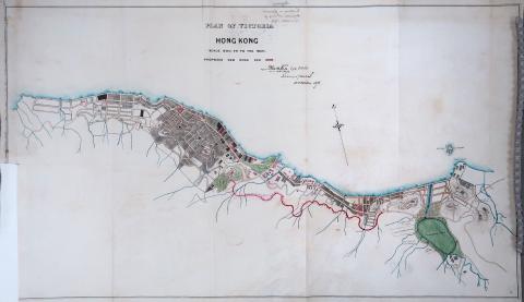
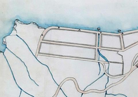
Here are examples of items on the western part of the map that caught my interest.
- A: Ouchterlony Battery.
- B: Queen's Road West ends here (roughly where St Louis School stands today), as the land to the west is occupied by the battery.
- C: The map shows the streams that are mostly hidden in underground pipes today. This one runs in a nullah along the centre of Water Street. It's the first time I've noticed that.
- D: The buildings marked in red are also worth a closer look, as they were government property. Ouchterlony Battery is an example of a military site, while D's arrow points to the No. 7 Police Station.
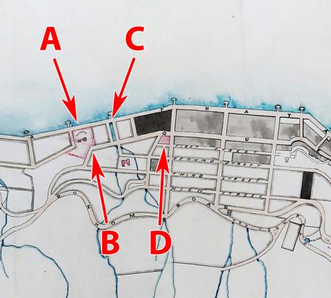
Here is another crop, this one showing Central district:
- E: Another government building, this shows Central Market in its older layout at an angle to the Praya (today's Des Voeux Road Central). In later generations it will be re-aligned to be at a right angle to the road.
- F: This shows a tank where the Glenealy Stream meets Upper Albert Road. Early Hong Kong relied on wells and streams for its drinking water, with tanks built on some of the larger streams to collect water. Some of the tanks further west are well known, but I don't remember seeing mentions of this tank before.
That all sounds good, so what's the problem?
Disappointments
A good map will help answer questions, e.g. we've got an open question about which years the Ouchterlony Battery was in existence.
It can also set us thinking about new questions, e.g. when was the tank at Glenealy Stream in use, and what was the water used for? What were the buildings shown by the red-filled outlines, and are any of them new to us?
But to use a map that way we need to trust that it is accurately drawn, and that we know which moment in time it captures. And that's where the disappointment begins...
Looking closer, my first concern is about the accuracy of the drawing.
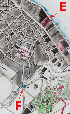
The area north of Happy Valley has a couple of dodgy captions:
- The blue inlet is labelled "Canal for sampane", which on other maps reads "Canal for sampans", and
- Over to the right is "Brighton Hill", which should clearly read "Leighton Hill".
There's another oddity at the western edge of the map.
The Praya should run west along the north shore then follow the coastline as it curves around to the south. But here the road curves long before the coastline turns south.
These are red flags that this map wasn't prepared with the greatest of care.
Second, and more important is the accuracy of the date. It was signed by the Surveyor General on 10 October 1873, so we'd expect the map to show Hong Kong at that time.
But...
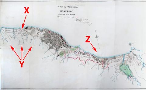
- X: Here the road is blocked by Ouchterlony Battery, yet on an 1866 map of that area, Queen's Road continues on through that ground, following the route we know today.
- Y: In the 1860s, the water supply was enhanced by a conduit that brought water around from the new reservoir at Pok Fu Lam, yet there isn't any sign of it on this map.
- Z: One of the arguments Kennedy used to promote his new road was the new pier off Praya East along the Wanchai seafront: the flow of goods between the pier and the warehouses would get in the way of traffic along the Praya, so an alternative route was needed. The pier was 1,000 feet / 304 metres long, so it would be hard to miss - but it isn't shown on the map.
It may be the 1866 map that is in error, it may have been a conscious decision to leave the conduit off this map, and as the pier was only completed in 1873 perhaps the map was just a few months out of date. But for now I'd recommend treating the "1873" date for this map with care. I'd originally planned to add it to Gwulo's maps as a new overlay, but decided against it.
Try again
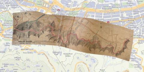
Kennedy's original document included a second map. It covers a smaller area but in more detail, showing the survey of the route of the new road. I've added this one as an overlay, crossing my fingers the date is accurate on this one.
Here's how it looks originally:
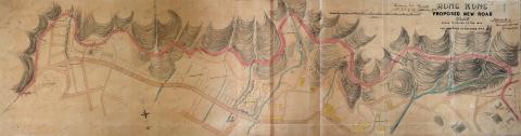
The original map is a rectangle, but see below how I've had to change its shape to make it an overlay? To line it up with the modern map I've had to stretch some sections, squeeze others, and also curve the map. There's always a risk that I'm making an unneeded change, that say the shape of a given road in 1873 really was different from its route today, and that by stretching the map I've lost that information. If in doubt please consult the copy of the original map shown above, so you can make your own judgements.
Third time lucky?
While all the steps to use the mapping tools are fresh in my mind, I've taken the chance to add a 1901 map as an overlay. It also comes from the National Archives, but this is one I photographed back in 2018.
No disappointments here - the map has a good level of detail, and it names many of the buildings which is a great help. One that stands out is the house named "Cleanse Skin" on Seymour Road, a name I don't remember seeing before.
Please click here to view the new 1901 map as an overlay, I hope you enjoy exploring it.
Comments
Thank you
A fascinating report indeed and very helpful. Can you download old maps of Hong Kong from the National Archives ?
Or, do we need to visit the Archives in London ? Thank you for any information on that. Best regards, Daniel
Land slides? War?
Were there any battles between the Brits and the pirates or the "ching government" in the 1870s hence the whole hill side could be shot out by cannon balls or severe washed out due to typhoons and heavy rain falls? In the 1960s, a whole over 10 stories tall hill side delux apartment building...just collapsed; slide down the hill along with the mud slide. Forget the name of the road where the building was sitting on, no idea if the government allow new apartment be built on the same site afterwards....
Please see my Facebook page…
Please see my Facebook page JanConSang_aka-ChasJanWan_Prescott_Arizona for an image of the foundation of Hop Yat Church on the Hong Kong Island, for possible explaination on why "roads" on map "disappeared"...Unable to post that photo here...An urban developement issue which will upset today's environmentalists....