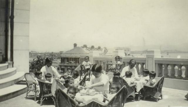
Babies and amahs on the veranda of the St John Ambulance Brigade in Tai Hang Road. I am most grateful for assistance given by team Gwulo to identify locations in my pics. This is one I have long wondered about. Mildred Dibden started in a 2-bed flat in Kowloon taking in abandoned babies in 1936. As numbers grew she moved to larger premises. In 1938 we are told she moved into the St John Ambulance Brigade building in Tai Hang. There she was offered the large hall with a small kitchen and bathroom adjoining while she looked for somewhere more permanent. She was there for a few months before moving to a bungalow on Cheung Chau later in the year, and in 1940 she opened The Fanling Babies' Home.
Source: Jill Doggett
Date picture taken
1938
Comments
Initial Impressions
The building looks more like a mansion with a terrace rather than a flat with a balcony. Difficult but something to work on.
Correction
Sorry for balcony read verandah. My mistake.
Location
I agree that this appears to be a private house with a garden terrace. Is it possible that Observatory Road contained a private mansion at the top of the hill that was split into apartments?
The view in the background has me flummoxed. There seems to be an island or some reclamation going on in the back right. The low hills in the background could be eastern New Kowloon but I'm having a problem reconciling the foreground at the moment
Another view
Stonecutter Island
This new image makes me think the island in the background might be Stonecutter Island. The hill on the right in the latest image is consistent with Tai Mo Shan.
Are there any references to other properties located on HK Island that would fit?
Causeway Bay?
Based on both of the above pics, I think the following can be seen;
1. The sun is high in the sky, but still shining into the camera. Therefore, the photo was taken around the middle of the day and the camera was pointing roughly north.
2. Above the balustrade in the distance on the right of the pics are two ridgelines. The nearest is much lower and nearer than the furthest. Some buildings can be seen vaguely. The furthest ridgeline is much higher and further away, but very indistinct. The relative sizes of these ridgelines remind me of the view across Victoria Harbour from HKI with the Nine Dragons being the furthest ridgeline and the hills within Kowloon being the nearest.
3. This side of the nearest ridgeline seems to be a stretch of water. Looking through the balustrade, a horizontal line can be seen, with more flat surface, land or water, nearer the camera. Perhaps the horizontal line is the shoreline or a sea wall?
So we are looking for a location on the north shore of HKI with flat land or water to the right (east) of buildings. Causeway Bay with its typhoon shelter fits the bill. If correct, then the low ridgeline in the distance could be Hung Hom.
Looking at the two buildings nearest the camera, they are roughly in line, running away from the camera, i.e. roughly on a north/south axis. The pitched roof of the nearest has two large, decorative, distinctive, arc shaped structures facing the open space to the east, suggesting this side is the "front" of the building. The next building is of a much more modern design. At roof level, it has distinctive square, probably concrete, buttresses, perhaps separating the units within. There are other buildings behind and further away than these nearest two buildings, meaning that they are not actually on the harbour waterfront.
This 1930's photo of Causeway Bay is already on Gwulo; https://gwulo.com/media/20803 .
I think the modern building above the right side of the hull could be the buttressed building mentioned above, with the building partly covered by trees on its left being the one nearest the camera in Mildreds pics.
If so, that puts Mildreds verandah further to the left, perhaps the white building above the left end of the ship hull?
Possible alternative site
Thank you philk and gw for all that detective work! The only other possible location is the St John Ambulance Brigade premises in Tai Hang. I see Google says, 'It (Tai Hang) is home to many luxurious private apartments'. Mildred moved there in 1938 when she had 28 babies. Then it was Cheung Chau island and then Fanling in 1940.
St John's Ambulance!
It looks like it is the St John's Ambulance building. The southeast side of the building has a matching portico and balustrade.
See the balustrade here: https://earth.google.com/web/@22.27854122,114.1900044,14.48732722a,0d,4…
Re: St. John Ambulance HQ Building
Well done gw and very good work! Yes, one is overlooking Moreton Terrace (street location), the modern Bay View Mansions (first generation) and the then Queen's Recreation Ground. The clincher are the arc-like structures on the top of the older building in the main picture that can also be seen in the referenced photo provided by gw.
Today's Google Earth View showing the terrace, balustrade and entrance steps.
The line-of-sight view in the reverse direction can be seen in this aerial photo below:
Thank you
Awesome work once again guys. I am over the moon to have located that one. And that it's still there today is a huge bonus. Thanks for finding the period pics to back it up and thanks Google Earth that I can see it all today without leaving my desk! I can see I'm going to have to get some tickets to HK to see it in reality! Thanks again guys for your help, perseverance and expertise.