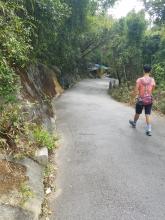
Jat's Incline has become one of our regular walks, and I'd noticed it has a marker stone a short distance uphill from the temple. The stone is down at bottom left in this view, and the yellow-coloured rock in the distance is part of the temple.

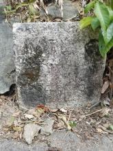
I've stopped to take a closer look a few times, but never been able to make out the writing:

So last week I went armed with my daughter's box of chalks:

There are three lines of text. I wasn't able to make out anything clear in the top line but the middle name has DINANC clear enough to say it read ORDINANCE.
The bottom line looks like a mix of numbers and letters. You'll see I chalked the number at the right as a 6, but looking at this photo I think the loop is the top of the nine not the bottom of the six. I think I can see the letters in the middle too, so it looks like:
???????
ORDINANCE
?? 25 SE 9?
I don't remember seeing an ORDINANCE marker stone before - has anyone else seen any examples?
And any guesses about the rest of the text, or what this stone was used for? It could refer to an Ordinance - a law that was passed? Or maybe I've imagined an "I" and it should be "ORDNANCE", connected with mapping the area?
Suggestions welcome!
Photos that show this Place
Comments
Re: Jat's Incline markers
Hi David,
Suggest to bring along a pack of flour with a paint brush on your next visit and sprinkle them onto the words. Flour are would probably be cleared away by ants or other insects in notime. One of my friends learning Fung Shui told me they are using this method to 'read' old engravings on stones\graves on site visits. Might have to bring along some latex gloves for the application as your hands would be a mess if you do it bare handed and could make a bigger mess with your camera.
T
Re: Jat's Incline markers
I google'd how to read old gravestones and it turns out chalk is a bad approach and so is flour: http://www.ncgenweb.us/newhanover/cem1.html
According to that page I'll have to head up there with some tin foil instead!
Re: how to read older engravings
Hi David,
I did not consider the micro-organism's damage to those. The site also mentioned the matter of shadows and light. Maybe I will switch on the LED light of my phone next time and see if that is sufficient. If not, there are other portable LED lighting panels (for photography) which may do the trick. If that works it would be less troublesome then using aluminium foils.
On the other hand, I believe I have also read some photography tutorials saying using ND filters and a tripod for longer exposture may do the same trick.
T
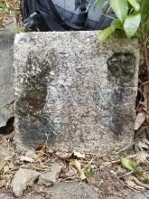
Re: JAT INCLINE ordinance stone
Hi, David.
A closer look of the stone.
????????
ORDINANCE
26 of 1937
There are letters from the side as well.
Re: JAT INCLINE ordinance stone
Thanks Herman, that is much easier to read. Please can I ask how you made it clearer?
Then the next question is what the ordinance 26 was about. I checked the online copies at https://oelawhk.lib.hku.hk/exhibits/show/oelawhk/browse, but unfortunately the later sections of the 1937 edition that cover years 1932-37 have been lost. Does anyone know another way to look it up?
Re: Numbers
I think the stone is dated 26 SE 1937.
New Territories/New Kowloon boundary stone at JATS INCLINE
I went to the site with my two sons at night. There was a lamp-post nearby. I thought the smartphone captured better shadow contrast image. In addition, Kevin and Justin used the aluminum foil to do the engraving of the writing as well.
Ordinance No. 26 of 1937
David:
The ordinance is the Interpretation Amendment Ordinance 1937. It contains miscellaneous changes to official titles and definitions (the current equivalent is the Interpretation and General Clauses Ordinance, or Cap. 1).
Section 2 of the 1937 ordinance defines 'New Kowloon' by reference to a map marked 'New Kowloon' dated 8 December 1937, signed by the Director of Public Works and countersigned by the Governor, and deposited in the Land Office.
Could it be that the stone is a boundary stone for New Kowloon, with a reference to the ordinance as the authority?
A copy of the ordinance can be found in the Hong Kong Government Gazette, 24 December 1937 on the HKUL Digital Initiatives >> Government Reports site. The Gazette (much more than the Historical Laws site) is the best place to go for ordinances as they were actually enacted.
Hope this helps!
Best wishes,
Chris
Mystery solved
Thanks Chris, that's a great help, and also good to know for future searches. (Tip for those future searches: Though the summary of entries listed at https://lib.hku.hk/hkgro/browseGa.jsp?the_year=1937 only mentions ordinance #24, Ordinances passed and assented to:- Sterling Salaries Conversion-No. 24 of 1937, the PDF for that entry shows it actually covers ordinances #24 - 28, and gives the details of each one.)
Back to the marker stone, and a boundary stone for New Kowloon is a very likely explanation. Unfortunately the map mentioned in the ordinance isn't included in the PDF file, but a bit of good luck helped out. I remembered seeing a map of New Kowloon in Empson's Mapping Hong Kong, and dug that out. It's Plate 4-6, and shows a map dated 8th Dec. 1937 that defines the extent of New Kowloon, so it's the missing map.
The map defines the northern boundary of New Kowloon as the 500 feet contour on the hills at the back of Kowloon. Now 500 feet is 152.4 metres, and looking at the location of the marker stone on the map, it is between the 150m and 160m contour lines, so I'll take that as confirmation.
I haven't read any mention of this before, so it's a good find, a Kowloon version of the Victoria City boundary stones on Hong Kong island. Maybe the local council would like to erect one of those Welcome To ... / You Are Now Leaving ... signs here, for New Kowloon!
I wonder if any more still exist? They'd likely have been erected wherever a road crossed the boundary.
Regards, David
Boundary STONE Engraving 2020-08-28
The missing map 1937 New Kowloon
Google "Plan of new kowloon"
https://images.app.goo.gl/cxSBfHQYxBF8FgFJ6
The tin foil worked well,
The tin foil worked well, thanks for posting that.
We walked along there again this morning, and the combination of the lower winter sun, and being a bit earlier in the morning meant the shadows were clearer than our first visit.
I can see there's also a "No." at the start of the third line of text, but I'm still not sure what the top line says.
The missing puzzle
I find the missing puzzle of New Kowloon boundary
New Territories/New Kowloon boundary at JATS INCLINE
Further evidence of the boundary stone at JAT INCLINE. The NT/NK boundary intersect with the JAT INCLINE approximately at the current location of the granite stone with inscription.
"........"
"Ordinance"
"No. 26 of 1937".
have a look for more clear NK/NT boundary
it show a clear cut at JAT’S INCLINE road, maybe more boundary stone at boundary / road / foot path cutoff point!
Re: ??NK/NT boundary stone near Beacon Hill
The NK/NT boundary is clearly seen in the Kowloon Street Map.
Accordingly, I have tried to search for possible boundary stone from the accessible footpath, starting from the western bound from Lai Chi Kok, walking uphill towards the NK/NT boundary.
There is a footpath walking uphill from Lung Cheung Road towards Beacon Hill. I notice threre is a granite stone on the side of the footpath, with possbile engraving on it while near the 'boundary'.
??N.K./N.T. boundary stone
Coordinates in the Map (Kowloon Street Plan)
Entrance of the footpath: 088 738
Granite stone: 088 741
Jat v Jat's
Herman
It appears you have located the source of the name change from the original "Jat" to Jat's. It's not clear if the change was deliberate or just a misunderstanding.
Phil
New stone(s)
James, thank you for the map - lots more possibillities! I'm sure there would have been a stone on the road from Wong Tai Sin up to Shatin Pass. I walk that way quite often, and will keep a look out.
Herman, please could you make a Place (https://gwulo.com/node/17628) for the new stone you've found, so we can see it on the map and have a page to gather any more information about it.
Regards, David
Re: JAT incline NK/NT boundary stone
Revisited the JAT incline NK/NT boundary stone. The loosened concrete wall on both side of the boundary stone revealed the inscription "NEW XXXXXTORIES" on the expected NT side. The inscription on the NK side revealed "NEW KOW".
Found NK/NT Boundary stone near Caldecott road
At we research the boundary of ST. Raphael's Catholic Cemetery, We find a mark on 1922 1:600 map "D" on the NK/NT boundary, according the position , we find NK/NT Boundary stone near Caldecott road
there are mark on stone
”New Kowloon “
“New Territories”
“Limit under ordinance No.26 of 1937”
Re-visited ??NK/NT boundary stone (Beacon Hill)
I am glad to see the recently upload photos of a newly found NK/NT Boundary stone near Caldecott Road by the team 'Historical Walk HK'. The inscription of "LIMIT UNDER" on the stone explained and solved the mystery of the upper inscription of the previously found boundary stone near JAT Incline.
I curiously opened my hiking album of March 2022 as I have taken a few photos of the previously ??NK/NT boundary stone near Beacon Hill recently, the same stone I passed by dated on May 2 2020 while on the way to the Meridian marker (North). Not to my surprise, I can read the same inscription "LIMIT UNDER" on the stone.
Mystery solved!
I can read "LIMIT UNDER ORDINANCE No. 26 OF 1937" and I believe it is one of the NK/NT boundary stone!
The same location near Beacon Hill.
Alumunium foil Engraving
"ORDINANCE No.26 of 1937" can be seen
"ORDINANCE No. 26 OF 1937"
"26 OF 1937"
"xxxxxOON"
Hi Herman,
Hi Herman,
I visited Beacon's one following your description so as the coordinate provided by historicalwalk. I also just created https://gwulo.com/node/58279
Thanks
NK/NT boundary
Thanks for keeping us updated with your finds.
I've added a Place for James's new stone, and tagged them so we can see them on the map: https://gwulo.com/taxonomy/term/18116/places-map
Mystery structure at Cheung Hang Road ( 2021-08-29 )
Assuming the New Kowloon / New Territories boundary separating any passage, footpath or major road going from south to north direction, I have started a quick exploration for possible NK/NT boundary stone placement site on Aug 21 2021.
I started from from the most west bound passage, i.e. Castle Peak Road.
After looking for certain possible placement site, no obvious boundary stone can be identified.
According to the map (1963 version), the next road of intersection will be Cheung Hang Road.
There is a cubic-like stone noticed at the lower end of the slope while walking uphill along Cheung Hang Road, which is roughly at the possible intersection.
It is covered with concrete probably due to slope maintenance.
Is it similar to the one at Jat's Incline???
I hope the slope keep its current condition. I opt and choose to leave the answer as "possible".
Castle Peak Rd - Tai Po Rd near NK/NT boundary (2021-08-11)
West bound of New Kowloon/New Territories boundary transversed Castle Peak Road and Tai Po road according to the Ordinance 26 of 1937 and a documented map signed by the Governors.
The NK/NT boundary near Castle Peak Road is approximately at the "5-Mile milestone"
The NK/NT boundary of at Tai Po Road is approximately at the "4.5-Mile milestone" which is just north to Caldecott Road.
Its is corresponding to "4.5mile" at Tai Po Road whereas the "5-mile" milestone Road is still there at Castle Peak.
At this boundary, Castle Leak Road (青山道) becomes Castle Peak Road-Kwai Chung (青山公路葵涌段).
Tai Po Road (大埔道) becomes Tai Po Road - Piper's Hill (大埔公路 -琵琶山段).
Near Tai Po Road, there was previous slope maintenance work at the Piper's Hill side and the slope near Cadecott road is covered by concrete spray.
I could not identified any boundary stone.
Either it is removed during slope maintenance or it is covered by the concrete spray.
I leave the answer "Possible".
But one interesting observation at both site is that there is a footbridge there.
Is it planned or more than coincidence at this NK/NT boundary intersection?
JAT INCLINE NK/NT Boundary stone ( August 2020 )
Photo capture of the front surface view of the JAT Incline NK/NT boundary stone back in August 2020 (for record purpose)
There was hard concrete spray dropped possibly during slope maintenance covering the right upper and left middle region. The inscription can be seen better in photos and supplemented by the aluminum foil engraving. The slope with concrete spray covering partially on both side of the stone was largely intact.
Those concrete spray has been removed in the photos taken in 2022.
Possible locations of NK/NT boundary stones
The newly found New Kowloon/New Territories boundary stone of Ordinance 26 of 1937 at Caldecott road allows us to fully decode all the inscriptions on the JAT's incline and the Beacon Hill NK/NT boundary stone. The team "Historical Walk HK" has visited onsite, recorded the locations and documented the 3 boundary stones shortly afterwards. The team opens an interesting topic since April 20 2022.
In the Newsletter of Gwulo: 2021 (week 6) ( gwulo.com/node/53566 ), the subscribers learnt that an easily overlooked granite markers on JAT's Incline turns out to be one of the stones erected to mark the boundary of New Kowloon. In the forum, new ideas, new thoughts come up with debate, constructive discussions and challenging ideas. Through browsing books in the library, online historic documents seaching and on-site visits, a mystery finding of walking downhill is solved. I believe this is interesting and it is a very good learning opportunity.
The challenge and fun ahead is to look for possible sites. After decoding of some of the inscriptions on the JAT's incline NK/NT boundary stone, it draws our attention to the possible related historic ordinance of Hong Kong, then it comes up with a map of "New Kowloon" dated 8th Dec 1937 countersigned by the governor and deposited in the land office. The map defined the northern boundary of New Kowloon as the 500feets (152.4m) contour on the Kowloon Hills.
A newly uploaded and shared map by the Historical Walk HK suggested possible locations.
Is/are there possible NK/NT boundary stone(s)?
I believe everything is possible!
History is all around us! Let's see the history!
I have tried to use an online map viewer with overlay function ( www.hkmaps.hk/mapviewer.html ). Choosing the reference map of 1941 (by Port Works Office, as I noticed the 150m contour is well defined), using the open street map as background map and the coordinates recently published, the locations approximate well using the overlay function. The three locations are having a passage of footpath or a road, or a road nearby intersect approximate at the 150m contour on the map.
Location of NK/NT boundary stone - JATs incline ( 1941 map; www.hkmaps.hk/mapviewer.html )
Location of NK/NT boundary stone - Beacon Hill ( 1941 map; www.hkmaps.hk/mapviewer.html )
Location of NK/NT boundary stone - Caldecott road ( 1941 map; www.hkmaps.hk/mapviewer.html )
With this observation, the possible sites of further boundary stones will be of any passage, footpath or minor or major road intersect at the 150m contour of the southern side of the Kowloon Hills extending from Lai Chi Kok (west) to LyeMun points (east).
One interesting found on the old maps to share regarding possible locations.
All the "passage" going uphills from southbound to northbound intersect near 150m contour Kowloon Hills are reaching a "pass" in the old maps.
Lai Chi Kok Pass (near Caldecott Road/Tai Po Road)
Railway Pass (near Beacon Hill)
Kowloon pass
Shatin pass
Grasscutter pass
Jat Incline
Custom pass
Later placement of additional boundary stones or relocations due to road realignment are possible.
Any ideas or suggestions? ( the reference map is used as an accompany report of control and development of the port of Hong Kong February 1941).
Passage intersections near 150m contour level (1941 map near Kowloon Pass; www.hkmaps.hk/mapviewer.html )
Passage intersections near 150m contour level (1941 map near black Hill; www.hkmaps.hk/mapviewer.html )
Cheers!
re: Possible locations of NK/NT boundary stones
Hi Herman,
One set of possible locations is where a road or path crosses the boundary. You've got the list of potential sites above.
Other possible sites can be where the boundary joins / leaves the 500-foot contour, and also below the 500-foot contour where it changes direction (in these lower sections the boundary is a series of straight lines, and there would probably have been a marker stone at the corners). The recent finds of additional Victoria City boundary stones are examples of these.
Good luck with your hunting!
Regards, David
we find 5 WDL15 WDBS 4 of them maybe NKBS