Given the clamour for a new road to the NT, I guess the photo has to do with the commencment of the Route TWSK Project.The pimply hill may be this one here
this is the famous Kwun Yam Shan. I'm sure one of the former soldiers who has posted on Gwulo said he and his fellow soldiers called it "Betty Grable's nipple" :)
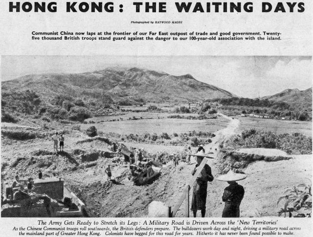
From the angle this looks like the Lam Tsuen valley looking southwest towards the gap that leads into Pat Heung, which would mean this is most likely Lam Kam Road.
This could possibly be the start of Route Twisk which was started around 1949+?. 54 Sqn RE were billeted at Sek Kong and they with the plant troop worked on Twisk which came out at Tsuen Wan around 53+?.
My thanks Phil for your reply. I know that 54 Fld Sdn RE were at Fanling around '49 onwards which made me think that was the start of TWSK. Was it not 54 that built TWISK with their plant troop?.
Followed-up on the construction of the road in the main photo.
"The Lam Tsuen valley road, began in 1949, was completed during the year and provides a direct link between Taipo and Kam Tin via Sek Kong. Another new road through the hills from Sek Kong to Fanling was well advanced at the end of the year and work had started on a third from Tsun Wan to Sek Kong. "
This Google Streetview shows the same skyline, confirming Phil's ID that the old photo shows today's Lam Kam Road (called 'Lam Tsuen valley road' in the clipping Moddsey found):
Comments
Perhaps Route TWSK (TWiSK)
Given the clamour for a new road to the NT, I guess the photo has to do with the commencment of the Route TWSK Project.The pimply hill may be this one here
Kwun Yam Shan
this is the famous Kwun Yam Shan. I'm sure one of the former soldiers who has posted on Gwulo said he and his fellow soldiers called it "Betty Grable's nipple" :)
From the angle this looks like the Lam Tsuen valley looking southwest towards the gap that leads into Pat Heung, which would mean this is most likely Lam Kam Road.
Re: Road Construction
Thanks Phil for the clarification.
Route Twisk.
This could possibly be the start of Route Twisk which was started around 1949+?. 54 Sqn RE were billeted at Sek Kong and they with the plant troop worked on Twisk which came out at Tsuen Wan around 53+?.
not route twisk
route twisk is on the other side of the gap (on the right) formed by Kwun yam shan. This location is between Taipo and Fanling.
Route TWISK
My thanks Phil for your reply. I know that 54 Fld Sdn RE were at Fanling around '49 onwards which made me think that was the start of TWSK. Was it not 54 that built TWISK with their plant troop?.
Road Building in the NT
Followed-up on the construction of the road in the main photo.
"The Lam Tsuen valley road, began in 1949, was completed during the year and provides a direct link between Taipo and Kam Tin via Sek Kong. Another new road through the hills from Sek Kong to Fanling was well advanced at the end of the year and work had started on a third from Tsun Wan to Sek Kong. "
Hong Kong Annual Report 1950 refers
This Google Streetview shows…
This Google Streetview shows the same skyline, confirming Phil's ID that the old photo shows today's Lam Kam Road (called 'Lam Tsuen valley road' in the clipping Moddsey found):