TNA ref: MR 1/797
See https://gwulo.com/node/56249 for more information
Date picture taken
1923
Gallery
Shows place(s)
TNA ref: MR 1/797
See https://gwulo.com/node/56249 for more information
Comments
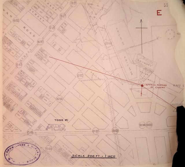
A question about the map.
A question about the map. Does anyone know the meaning of the four-digit numbers inside the circles that appear at the junction of the roads?
4 Digit numbers?
The numbers are smaller towards the sea, and higher towards the hills.
The numbers run down Nam Cheong Street, and there "seems" to be a watercourse down the middle of that street (assuming I'm reading the map right).
Is this a drainage map, and are these elevations? (in feet), this is a complete guess.
The street address numbers ?
The street address numbers ? One set for each side of the street ?
Elevations
Those are elevations from the sea level, likely in feet as the scale of this map is in feet and inches.
They can be seen in this contour map also.
https://gwulo.com/media/41298
Elevations on Map
Greetings!
Along Nam Cheong Street, the numbers started at 15 63 at Yu Chau Street, then increse in the northward direction. At Un Chau junction, it reads 19 37. The current elevation map - https://en-hk.topographic-map.com/maps/d2mc/Nam-Cheong-Park/ gives roughly an elevation of 19 metres at Yu Chau St, and 21 metres at Un Chau. So my first impression is that the numbers on the old map are in metres based on an old vertical datum. If correct, they are either road surface elevations, but I tend to think they would be specifying elevations of the nearest benchmark.
If these numbers are in feet, my guess is that they refer to below ground drainage elevations to two decimals, that is, the elevation at the bottom of a ditch/culvert.
Not related to the discussion above, I seem to remember way back they had city water tap for each city block, on the front of a building at ground level, just that they were locked so that people could not access it. Regards, Peter
Questions about the map
My guess, they are invert levels for the surface water drainge. Inverts are the bottom of pipes. Important when instructing contractors to excavate a trench and place pipes in position. Also as a record for future excavations.
My first ever comment. How do you do everyone. I arrived, aged 6, with my parents in April 1962 and grew up in Leightonhill.