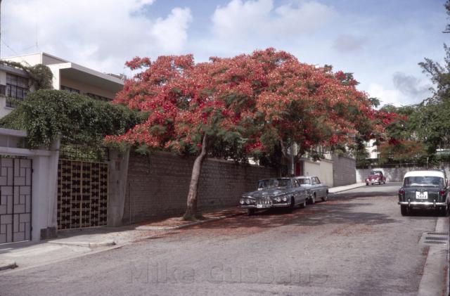
At a guess I would say this is on the eastern side of Waterloo Road (i.e. La Salle Side of KT) and is one of the side roads that runs up onto Oxford Road (such as Wiltshire or Durham Roads).
Philk you could be right....Oxford road possibly but i can't remember.Not La Salle as we used to live there.I remember learning to drive around this quiet area.
Greetings! It appears this street has not been identified. I seem to remember trees were few on Kowloon Tong sidewalk so it surviving into 1965 was a surprise and a sad loss. May I suggest that the cameraman was on Stafford Road looking north, and the street farther up running left-right (or west-east) would be Rutland Quadrant. The width and gradient of the roads match quite well.
The three-gutter inlet combo is no longer there, but across the street there are similarities. The 2009 Google street view shows the spot on the sidewalk where the beautiful tree apparently* once stood. After removing the tree, the area was covered by paving stones and their rectangular outline is visible. The gate is still there relative to the tree. The stone walls look similar but I cannot say they are identical given the quality of the old photo.
(* Edit: It might be a cover to underground services, as can be seen on nearby sidewalks.)
Two not so strong hints.... The next door neighbour moved their gate to the south and fixed up the curb to match the existing one. The two house roofs do not match, it could be the result of cosmatic alteration. I wonder what caused the watermark on the top several stone layers. Were they at one time covered by vines? Corrections and comments welcome! Regards, Peter
I don't think this is the right place. Stafford Road is basically flat whereas there is an obvious gradient to the road in Mike's photo as you can see from the stepped top of the walls.
Thanks Phil for the correction. My gradient comparison used Google street maps so in this case not accurate.
In my earlier search, there are two spots further north with steeper gradient but not much else to go by with the absence of a stone wall, and I will take another look. I thought about the tree droppings and sun's shadow which may indicate one spring late morning and the road running north.
Please take a look at Tim Fuk and Suffolk junction. On the north side of Suffolk Road, there is currently a 5 or 6-storey building that lines up with the houses on the east side of Tim Fuk Road. Unfortunately, I can't match any of the current trees with the one in the 1965 photo. If this is the right spot, where the cameraman was standing is now an entrance to the car parking area. A puzzle - Tim Fuk Road and houses along it are not on the 1956 map. Regards, Peter
Hi Peter, Tim Fuk Road is a relatively new road for the area because it crosses the land where St George's School (a British military school) used to be. I don't know when the school closed and was redeveloped but I get the impression it was still there in the 1980s (I could be wrong). Again, there is no real gradient in this part of Kowloon Tong...the slope in the roads doesn't really start until you go north of Suffolk Road. With this in mind there are only two places that would be appropriate: Kent Road and Devon Road and neither matches (I would expect to see some mountain as well). The style of building in Mike's photo makes me think this was not Kowloon Tong Estate but instead on either the eastern side of Waterloo Road (Wiltshire/Durham/College Roads for example) or perhaps somewhere in Yau Yat Tsuen where the original housing stock was largely built in the 50's. The problem is that Mike has posted two pictures (see the link in my old comment) of the same street but one is flipped and its difficult to determine which way round is the correct view.
Thank you Phil for your continuing support. I agree.
Kent and Devon were my early choices until I looked at their respective junctions. Not withstanding that there were actually no such houses in the area in 1965, Tim Fuk Road was my last hope west of Waterloo. I thought, perhaps the map was wrong; and if they moved mountains and streams, they could have taken out the fence and rerouted Suffalk to the north side of the building I mentioned earlier.
I looked at junctions east of Waterloo after reading your initial comments. I plan to re-visit them again.
As for Yau Yat Tsuen, I ventured there in about 1962 when they were building new houses there (not as huge and tall as today's). The area was barren, a few new houses just built, and yes, some streets had steep gradient. At the entrance to this new development (not sure Marigold or Magnolia) there was an arch showing its name in Chinese.
I lived in Kent Road and can confirm that is not Kent Road. St George's School was still there in the early 80s I remember. It does have a Kowloon Tong-y feel to it but I don't recognise it at present.
Hi Phil, as per your advice, here are the results of my Google visit to the area east of Waterloo Road.
The work assumes that the 1965 photo shows its correct side. The large canopy suggests there were two trees. Assuming that the camera was at level and zero tilt (see gate on the right side of photo), it shows the road and wall in the background on a small ascend from right to left.
1. Oxford Road looking north at Hereford Road: I think the present stone wall at the southeast corner is the original wall, so this disqualifies this site. Its mortar line shows this part of the road does not have a steep gradient like the one in the 1965 photo. Present Hereford Road descends mildly from right to left.
2. Wiltshire Road looking east at Oxford: The sidewalk and mortar on Wiltshire Road corner shows this spot having a gradient similar to that in the 1965 photo. About 120 feet to the west, there currently stands a mature tree which might be one of the two in the 1965 photo. While still on Google street views, please compare the house on the east side of Oxford with the white spot in the 1965 photo (behind the VW car). This spot is the best of all candidates.
3. Wiltshire Road looking west at Cambridge Road: No similarities can be found. Cambridge’s road gradient here is opposite to that in the 1965 photo.
4. Durham Road looking east at Oxford Road: The current offset of Durham Road at this junction is not in the 1965 photo. Also the Durham gradient here is fairly mild.
5. Durham Road looking east at LaSalle Road: One reader has already ruled this out.
6. College Road looking north at Nga Tsin Wai Road: The current College Street is wider than the street in the 1965 photo. The current sidewalks look original, so I assume no changes have been made to widen the road. It has a gradient similar to that in the 1965 photo.
@ Option 5: "Durham Road looking east at LaSalle Road: One reader has already ruled this out."
I lived on Lancashire Road near the corner of La Salle Road for three years 1976-9 and then moved around the corner onto La Salle Road almost opposite Dumbarton Road junction for a further 2 years. I am therefore quite familar with that area. I suggest that option 5 is correct ( i.e the photo was taken on Durham Rd. looking east towards La Salle Rd., in spite of one reader disagreeing.
It's possible Mike was referring to the road where he took the picture rather than the road that runs across the background. It certainly looks very similar despite the changes. But can you confirm which orientation is the likely correct one?
If you go to Google maps 'street view' on DurhamRoad, and position the view looking eastwards towards La Salle Road ( which is crossing at the T-junction) I think the camera in that 1965 photo was near the left hand pavement curb, outside what is now 11B Durham Road. On the right hand pavement is a lamp post which I also believe to be exactly in the same position as in the "then" and "now" pictures. There is also a narrow rear lane exiting adjacent to the lamp pole. In the the 1950's picture this spot is too dark to see the lane but I believe it to be there. Just above the first of the two parked cars you can see small white patch of wall which would make sense because this would be the rear wall of the building compound near where the lane exits. I also think the level of incline on the road surface at this spot matches both picures.
I think Chinarail has found the correct site (Option 5) for the 1965 photo. Thank you Chinarail. Who would think a lamppost would shed light on discussion decades later. The rear lane, though its entrance not convincingly visible, makes it top choice. Other options west of Oxford do not have rear lanes.
The 1956 map shows two lots on the south side of Durham between Oxford and La Salle. The building on the west lot (Oxford corner) has a large footprint which I think remains the same today. When I looked at the roof corner and the two gates in the photo, I thought there must be a third lot and building but out of picture, hence not a logical option.
Current Google maps show a line dividing the larger building. A 2009 street view shows there was a physical separation between the two front yards, the landscape, so it has been a semi-detached we call today. It’s a new stone wall now with a gate at corners. That the two gates with different design and close together is a mystery to me. The mature tree now standing could be one of those in the old photo. Regards, Peter
I must admit I'm still not convinced. If you look at the similar (but flipped) image below, you will see that the road appears to be significantly longer than that small section of Durham Road between Oxford Rd and LaSalle Road. By the looks of it it contains another large plot with a grey wall between the camera and the first tree. If you are saying the lamppost sits in front of the alleyway, then that would put the current plot (containing occupied by #18 and #16) as being the wall behind the closest tree on the image... but then that leaves no room for the property with the grey wall. I'm inclined to believe the location is #2 on Peter's list: Wiltshire Road looking east up to Oxford Road.
Current street views show, when looking from Durham Road, La Salle Road has a downward gradient from right to left or northbound. From Wiltshire and especially when looking at the stone works on Oxford Road, Oxford Road has a rising gradient northbound which appears to match the top photo on this page.
Thank you Phil for the flipped photo, a new hint and logic. Regards, Peter
1. @" you will see that the road appears to be significantly longer". I have to disagree on this taking into account that the camera position in the image above would have been further back and closer to the Oxford Road junction. This consideration together with a different camera lens aberration would easily make the road look slightly longer .
2. Addressing your suggestion for Option 2 , i.e. the pictures were taken in Wiltshire Road facing east to Oxford Road...... I wish to counter this with yet another point of view. Both of the 1964 photos suggest that the road therein is significantly wider than Wiltshire Road. There are cars parked on both sides of the road near the trees but the gap remaining is still wide enough for two cars travelling in opposing directions to pass each other. This would not be the case in Wiltshire Road. If there are cars parked on either side of Wiltshire road, to my eye they would only be sufficient gap for one car to pass down the road centre.
I have done some "fiddling" with photoshop to superimpose 4 cars abreast, indicating that this is a wider road than Wiltshire Road. The photo on the left is current day Wiltshire Road with a superimposed mirror image of second car on the right of the red arrows. I suggest there is only sufficient width for one car to pass in between.
Durham-Wiltshire-Roads.jpg, by Chinarail
The debate is still therefore open., however for now , I still stick with Durham Road.
Cheers.
P.S.
It's a pity that the photos are not higher resolution. If they were high resolution we might be able to pick on some distinguishing features of the surviving stone walls, although these might also have been rebuilt.
If you look at the aerial image I posted you can see that the property at #18 & #16 is the same one as back in the 60's. Let's assume that the grey wall in the flipped image below belongs to #18.
Kowloon Tong 1965 (flipped), by Philk
So if this is the correct orientation (and the grey wall belongs to #18) then I would expect to see the alleyway on the other side of the grey wall's entrance gate.
Okay, let's assume that the grey wall in fact belongs to #16 which would put Mike standing on Oxford Road. This is possible but then doesn't explain why there looks to be another property line at the far right of the image (see where the garden wall turns in by the tree and there looks to be a plot marker at the base of the outside wall). And this also means that both properties have inverted the configuration of their entrance gates in the years since the image was snapped. I guess it's possible, but I'm not convinced yet.
Greetings! The 1965 shows I believe a British car and an American car the latter a bit wider. It appears possible to have two cars parked between them but they would not be able to fully open their door(s). Two more British cars perhaps, but not two more American cars. On Wiltshire Road, the September 2019 Google street views shows a small white sedan parked on one side, and a red Benz which is a bit wider on opposite side. So this may be a good comparison.
There is a mature tree on the south side of Wiltshire Road and its lower main trunk leans towards the road, a feature similar to the tree in the 1965 photo though I am not sure if it is the same tree. The Google view from just west of the tree shows it may be possible to park two white sedans on the live path.
Now onto Durham approaching La Salle, I picked February 2009 view because there is a red taxi I can use to estimate parking possibility. I estimate its width similar to the white sedan on Wiltshire. It appears four such taxi can be parked across with similar air space as on Wiltshire, perhaps a bit more but not by a lot. If these roads in the same neighbourhood were designed by the same government officials, they should all have the same width.
The current gate on La Salle Road does not appear in the 1965 photo, so it would be added after 1965 if indeed Durham is the correct option. Regards, Peter
Thank you Phil for the "flipped" photo. I think it (and the top-of-page photo) is showing the correct side. They drive on the left so I would say that they also park on the left. There is indeed another residential building down slope from the tree.
Mike, the two photos were focusing on the same tree. One appears to have been taken while sitting (by you or instructor) inside the car. The other photo (top of this page) appears to have been taken from a standing position on or next to the curb. Do you remember stepping out of the car? I am still trying to find a matching scene west of Waterloo Road. Regards, Peter
If you've got easy access to higher-resolution scans (or the slides) of this view and the one at https://gwulo.com/atom/16064, please could you take a look at the car's license plates and let us know which one is the right way round, and which has been flipped?
It'd also be good to know the couple of photos you took before and after these two, as they might give a clue as to the route you took as you walked around taking these photos. I bet 1965 you never expected you'd be asked about these photos over 50 years later!
There is another potential location I hadn't really considered and that is the lower section of Kent Road where it drops down from Somerset Road at an angle. The current road has a vague resemblance and certainly has enough of a gradient. Unfortunately the govt mapping website isn't functioning properly for me at the moment so I can't view the aerial images to see whether or not the suggestion makes sense.
I live on Oxford Road and walk through Wiltshire Road pretty frequently. Enclosed is a pic I took earlier in the summer and I am almost certain that the original pic in the post depicts Wiltshire Road.
DA86FFBA-B632-498F-B2B9-40F9D7DF60BE.jpeg, by Debo
Good question and I am afraid not - I have what I believe to be a similar type of tree (to the one in the original pic) in front of my place, and that one still had its flowers around the same time when I took the new pic. Will keep an eye out again next spring.
Given I walk around the neighbourhood quite regularly there's really no other spot with that slope / view. As others have pointed out, Durham Rd would be the closest candidate in terms of the slope, but it doesn't end in a T, and the Kowloon Tsai Home Owner Assoc. club house (which should be on the RHS) should already be in existence when the original pic was taken. But the pic shows residences so...
Thank you Debo for your reply. When buildings keep changing and gates moved, even sidewalk and gutters, it is nice to have a local to confirm the site. The tree reminds me of what once a quiet neighbourhood. Regards, Peter
Update. The agriculture and fisheries department has recently tagged the tree in the picture as a Poinciana. If you look it up on Google you will see that it has red/orange flowers, similar to the tree in the original photo.
Hi tkjho. I believe you are referring to that white spot above the VW car in the 1965 photo. That would be the building on the east side of Oxford. The 1963.2 air photo ( https://www.hkmaps.hk/mapviewer.html ) shows the roof of a building at that spot, which matches well with the present building 華園 (Google Earth). Regards, Peter
I'm referring to the white patch in the blue sky to the right of the low dark cloud just above the treeline. In the original photo, it looked just like a cloud. But after I darkened it, the angular outline of a building appeared. It looked blurrier and more out of focus than the building behind the VW, maybe because the top floors were a lot brighter than the lower floors & got blown out, or that building was actually a lot further away.
Referring to the top/original photo on this page posted by Mike, there appears to be a part of a building at the end of Wiltshire. This spot is midpoint between the VW and the other two parked cars, or the line separating the colour of the two walls - though they were part of the same property as shown in the 1963.2 air photo. If correct, the feature above the tree line might be the walkout roof top, though the line of sight is not convincing. The current roof in Google Earth is different, so the original building is no longer there. Correction welcome, until I got it right. Regards, Peter
I can see a few horizontal and vertical lines above the leaves. Maybe they put up an illegal enclosure on the rooftop.
I darkened the photo much more to bring out the hi-rise. It looks more angular, with some horizontal lines, and looks more like a man-made structure than a cloud to me.
Hello tkjho. Thank you for processing the photo to enhance the features you mentioned.
I have one question. In your processed photo, the white object/patch above the treeline over the red car looked very “granular” too, perhaps more “granular” than the feature you pointed at. Yet in the top photo, that white object/patch was truely clouds. It seems the processing adds considerable granularity to the photo. This may make your "granular" claim less convincing. Is it possible to re-process again to better support the claim? TIA
Interesting theory but if you remember the airport was close by at that time, ie plot ratio and height restrictions on buildings in Kowloon Tsai were quite strict, making a high rise in that location unlikely.
In addition I have lived in the neighbourhood since the 80s and don't recall ever seeing such a building in the vicinity, so if it existed if it must have been torn down and replaced by a low rise - again an unlikely occurence in HK.
The white patch in the sky in the really dark photo is the area I referred to. It looked like a cloud in the original photo maybe because of overexposure under bright direct sunlight.
I darkened the other photo by just a touch, the building is clearly seen in this one.
Hello all, perhaps another piece of information against Option 5:
First occupancy of Durham Street 18 was in 1955. Hence, at the time Mike was taking the photo, that building and very likely its fence too, would appear on the right of the photo next or close to the alleyway. Yet, both the rounded corners and the shape of the fence were different in the 1965 photo.
A look into option 2:
I agree with Debo that option 2 by Peter (OldTimer) is a very possible candidate. By comparing the 1965-photos (of Mike) with maps (1965.1 of hkmaps) and aerial photo (1963.2 of hkmaps), many common features in the 1965-photos could be found, including
1: possibly an ornament at the main entrance to Oxford Road from Wiltshire Road 12.
2: a rise in the fence of Wiltshire Road 10.
3: main entrance (not driveway) from Oxford Road 21 to Wiltshire Road.
4: driveway of Wiltshire Road 13 and 11.
5: driveways of Wiltshire Road 10 and 12.
6: Wah Yuen
7: fence of Wiltshire Road 12, the western (inner) face of the eastern wall.
8: main building of Wiltshire Road 12.
9: annex building of Wiltshire Road 12.
........ with some unresolved issues inevitably, including:
3 did not appear in maps but only aerial photo.
Features of 6 in 1965-photos do not clearly resemble those on present Wah Yuen.
9 could only be barely seen in the aerial photo and no sufficient details of it in maps.
I’m afraid that introduction of the possible high-rise building would not help the comparison here. It’d be better to deal with the questions arise from it separately which include: consistency of its positions in different 1965-photos, different contrast of features/shadow on its walls with other buildings, sufficiency of resolution to interpret the granularity etc. This remains an interesting theory as Debo mentioned, and his question worths further investigations to explore its values of consideration.
Thanks to Mike for the wonderful photos. Thanks to Peter (OldTimer) for listing out the options. And thanks to philk, eurasian_david, Chinarail, David, tkjho, Debo and people aforementioned for the discussions and information.
After seeing Debo's modern photo I now agree....Defintely Wiltshire Road . Also my memory of this area from the late 1970s has suddenly clicked back into sync. In an earlier comment I expressed the view that the road width in the first picture was much wider than Wiltshire Road when viewed in Google Earth photos but I had overlooked the fact that my "screen shot" photo of Wiltshire Rd was taken at the other end of the street (from the trees) and that the pavements are now much wider now at this end. ( Apologies for giving a false trail) .I think we can safely close the file on this case now.......Problem solved. Happy New Year everyone.
A bit of extra detail to confirm the location: in this companion photo there are a couple of lot marker stones in the left foreground, but unfortunately they aren't clear enough to read.
the pic brings back such GREAT memories :) Glad debate confirmed…our family lived at both 43 Cumberland Rd & 1 Wiltshire Rd until end of 1959 when we moved to HK side~ Lugard Rd. Remember as children sneaking out Wiltshire Rd back door to run to Mo Fan Tsuen behind think it’s now the Broadcast Drive area where we would get sweets, games and water ‘transfers’ to stick on arms ~ HAPPY days!
Comments
Kowloon Tong
Is this a flip of the other Kowloon Tong Photo?
At a guess I would say this is on the eastern side of Waterloo Road (i.e. La Salle Side of KT) and is one of the side roads that runs up onto Oxford Road (such as Wiltshire or Durham Roads).
Kowloon Tong Photo
Philk you could be right....Oxford road possibly but i can't remember.Not La Salle as we used to live there.I remember learning to drive around this quiet area.
regards Mike
Kowloon Tong (Stafford Road?)
Greetings! It appears this street has not been identified. I seem to remember trees were few on Kowloon Tong sidewalk so it surviving into 1965 was a surprise and a sad loss. May I suggest that the cameraman was on Stafford Road looking north, and the street farther up running left-right (or west-east) would be Rutland Quadrant. The width and gradient of the roads match quite well.
The three-gutter inlet combo is no longer there, but across the street there are similarities. The 2009 Google street view shows the spot on the sidewalk where the beautiful tree apparently* once stood. After removing the tree, the area was covered by paving stones and their rectangular outline is visible. The gate is still there relative to the tree. The stone walls look similar but I cannot say they are identical given the quality of the old photo.
(* Edit: It might be a cover to underground services, as can be seen on nearby sidewalks.)
Two not so strong hints.... The next door neighbour moved their gate to the south and fixed up the curb to match the existing one. The two house roofs do not match, it could be the result of cosmatic alteration. I wonder what caused the watermark on the top several stone layers. Were they at one time covered by vines? Corrections and comments welcome! Regards, Peter
Stafford Road
Hi Peter
I don't think this is the right place. Stafford Road is basically flat whereas there is an obvious gradient to the road in Mike's photo as you can see from the stepped top of the walls.
Phil
Kowloon Tong
Thanks Phil for the correction. My gradient comparison used Google street maps so in this case not accurate.
In my earlier search, there are two spots further north with steeper gradient but not much else to go by with the absence of a stone wall, and I will take another look. I thought about the tree droppings and sun's shadow which may indicate one spring late morning and the road running north.
Please take a look at Tim Fuk and Suffolk junction. On the north side of Suffolk Road, there is currently a 5 or 6-storey building that lines up with the houses on the east side of Tim Fuk Road. Unfortunately, I can't match any of the current trees with the one in the 1965 photo. If this is the right spot, where the cameraman was standing is now an entrance to the car parking area. A puzzle - Tim Fuk Road and houses along it are not on the 1956 map. Regards, Peter
Tim Fuk Road
Hi Peter, Tim Fuk Road is a relatively new road for the area because it crosses the land where St George's School (a British military school) used to be. I don't know when the school closed and was redeveloped but I get the impression it was still there in the 1980s (I could be wrong). Again, there is no real gradient in this part of Kowloon Tong...the slope in the roads doesn't really start until you go north of Suffolk Road. With this in mind there are only two places that would be appropriate: Kent Road and Devon Road and neither matches (I would expect to see some mountain as well). The style of building in Mike's photo makes me think this was not Kowloon Tong Estate but instead on either the eastern side of Waterloo Road (Wiltshire/Durham/College Roads for example) or perhaps somewhere in Yau Yat Tsuen where the original housing stock was largely built in the 50's. The problem is that Mike has posted two pictures (see the link in my old comment) of the same street but one is flipped and its difficult to determine which way round is the correct view.
Phil
Kowloon Tong (likely not)
Thank you Phil for your continuing support. I agree.
Kent and Devon were my early choices until I looked at their respective junctions. Not withstanding that there were actually no such houses in the area in 1965, Tim Fuk Road was my last hope west of Waterloo. I thought, perhaps the map was wrong; and if they moved mountains and streams, they could have taken out the fence and rerouted Suffalk to the north side of the building I mentioned earlier.
I looked at junctions east of Waterloo after reading your initial comments. I plan to re-visit them again.
As for Yau Yat Tsuen, I ventured there in about 1962 when they were building new houses there (not as huge and tall as today's). The area was barren, a few new houses just built, and yes, some streets had steep gradient. At the entrance to this new development (not sure Marigold or Magnolia) there was an arch showing its name in Chinese.
Regards, Peter
I lived in Kent Road and can
I lived in Kent Road and can confirm that is not Kent Road. St George's School was still there in the early 80s I remember. It does have a Kowloon Tong-y feel to it but I don't recognise it at present.
1965 Kowloon - somewhere
Hi Phil, as per your advice, here are the results of my Google visit to the area east of Waterloo Road.
The work assumes that the 1965 photo shows its correct side. The large canopy suggests there were two trees. Assuming that the camera was at level and zero tilt (see gate on the right side of photo), it shows the road and wall in the background on a small ascend from right to left.
1. Oxford Road looking north at Hereford Road: I think the present stone wall at the southeast corner is the original wall, so this disqualifies this site. Its mortar line shows this part of the road does not have a steep gradient like the one in the 1965 photo. Present Hereford Road descends mildly from right to left.
2. Wiltshire Road looking east at Oxford: The sidewalk and mortar on Wiltshire Road corner shows this spot having a gradient similar to that in the 1965 photo. About 120 feet to the west, there currently stands a mature tree which might be one of the two in the 1965 photo. While still on Google street views, please compare the house on the east side of Oxford with the white spot in the 1965 photo (behind the VW car). This spot is the best of all candidates.
3. Wiltshire Road looking west at Cambridge Road: No similarities can be found. Cambridge’s road gradient here is opposite to that in the 1965 photo.
4. Durham Road looking east at Oxford Road: The current offset of Durham Road at this junction is not in the 1965 photo. Also the Durham gradient here is fairly mild.
5. Durham Road looking east at LaSalle Road: One reader has already ruled this out.
6. College Road looking north at Nga Tsin Wai Road: The current College Street is wider than the street in the 1965 photo. The current sidewalks look original, so I assume no changes have been made to widen the road. It has a gradient similar to that in the 1965 photo.
Comments and corrections welcome! Regards, Peter
1965 - Kowloon - Somewhere
@ Option 5: "Durham Road looking east at LaSalle Road: One reader has already ruled this out."
I lived on Lancashire Road near the corner of La Salle Road for three years 1976-9 and then moved around the corner onto La Salle Road almost opposite Dumbarton Road junction for a further 2 years. I am therefore quite familar with that area. I suggest that option 5 is correct ( i.e the photo was taken on Durham Rd. looking east towards La Salle Rd., in spite of one reader disagreeing.
Durham Road
It's possible Mike was referring to the road where he took the picture rather than the road that runs across the background. It certainly looks very similar despite the changes. But can you confirm which orientation is the likely correct one?
Durham Road
If you go to Google maps 'street view' on DurhamRoad, and position the view looking eastwards towards La Salle Road ( which is crossing at the T-junction) I think the camera in that 1965 photo was near the left hand pavement curb, outside what is now 11B Durham Road. On the right hand pavement is a lamp post which I also believe to be exactly in the same position as in the "then" and "now" pictures. There is also a narrow rear lane exiting adjacent to the lamp pole. In the the 1950's picture this spot is too dark to see the lane but I believe it to be there. Just above the first of the two parked cars you can see small white patch of wall which would make sense because this would be the rear wall of the building compound near where the lane exits. I also think the level of incline on the road surface at this spot matches both picures.
Kowloon Tong 1965
I think Chinarail has found the correct site (Option 5) for the 1965 photo. Thank you Chinarail. Who would think a lamppost would shed light on discussion decades later. The rear lane, though its entrance not convincingly visible, makes it top choice. Other options west of Oxford do not have rear lanes.
The 1956 map shows two lots on the south side of Durham between Oxford and La Salle. The building on the west lot (Oxford corner) has a large footprint which I think remains the same today. When I looked at the roof corner and the two gates in the photo, I thought there must be a third lot and building but out of picture, hence not a logical option.
Current Google maps show a line dividing the larger building. A 2009 street view shows there was a physical separation between the two front yards, the landscape, so it has been a semi-detached we call today. It’s a new stone wall now with a gate at corners. That the two gates with different design and close together is a mystery to me. The mature tree now standing could be one of those in the old photo. Regards, Peter
Durham Road
I must admit I'm still not convinced. If you look at the similar (but flipped) image below, you will see that the road appears to be significantly longer than that small section of Durham Road between Oxford Rd and LaSalle Road. By the looks of it it contains another large plot with a grey wall between the camera and the first tree. If you are saying the lamppost sits in front of the alleyway, then that would put the current plot (containing occupied by #18 and #16) as being the wall behind the closest tree on the image... but then that leaves no room for the property with the grey wall. I'm inclined to believe the location is #2 on Peter's list: Wiltshire Road looking east up to Oxford Road.
Kowloon Tong 1965
Current street views show, when looking from Durham Road, La Salle Road has a downward gradient from right to left or northbound. From Wiltshire and especially when looking at the stone works on Oxford Road, Oxford Road has a rising gradient northbound which appears to match the top photo on this page.
Thank you Phil for the flipped photo, a new hint and logic. Regards, Peter
Durham Road vs Wiltshire Road
1. @" you will see that the road appears to be significantly longer". I have to disagree on this taking into account that the camera position in the image above would have been further back and closer to the Oxford Road junction. This consideration together with a different camera lens aberration would easily make the road look slightly longer .
2. Addressing your suggestion for Option 2 , i.e. the pictures were taken in Wiltshire Road facing east to Oxford Road...... I wish to counter this with yet another point of view. Both of the 1964 photos suggest that the road therein is significantly wider than Wiltshire Road. There are cars parked on both sides of the road near the trees but the gap remaining is still wide enough for two cars travelling in opposing directions to pass each other. This would not be the case in Wiltshire Road. If there are cars parked on either side of Wiltshire road, to my eye they would only be sufficient gap for one car to pass down the road centre.
I have done some "fiddling" with photoshop to superimpose 4 cars abreast, indicating that this is a wider road than Wiltshire Road. The photo on the left is current day Wiltshire Road with a superimposed mirror image of second car on the right of the red arrows. I suggest there is only sufficient width for one car to pass in between.
The debate is still therefore open., however for now , I still stick with Durham Road.
Cheers.
P.S.
It's a pity that the photos are not higher resolution. If they were high resolution we might be able to pick on some distinguishing features of the surviving stone walls, although these might also have been rebuilt.
Perhaps this aerial shot from
Perhaps this aerial shot from 1967 will help us to rule either one out:
https://www.hkmapservice.gov.hk/OneStopSystem/map-search/getPreviewFile?itemId=DAP&sheetNo=1967-5166
DUrham
If you look at the aerial image I posted you can see that the property at #18 & #16 is the same one as back in the 60's. Let's assume that the grey wall in the flipped image below belongs to #18.
So if this is the correct orientation (and the grey wall belongs to #18) then I would expect to see the alleyway on the other side of the grey wall's entrance gate.
Okay, let's assume that the grey wall in fact belongs to #16 which would put Mike standing on Oxford Road. This is possible but then doesn't explain why there looks to be another property line at the far right of the image (see where the garden wall turns in by the tree and there looks to be a plot marker at the base of the outside wall). And this also means that both properties have inverted the configuration of their entrance gates in the years since the image was snapped. I guess it's possible, but I'm not convinced yet.
Kowloon Tong 1965
Greetings! The 1965 shows I believe a British car and an American car the latter a bit wider. It appears possible to have two cars parked between them but they would not be able to fully open their door(s). Two more British cars perhaps, but not two more American cars. On Wiltshire Road, the September 2019 Google street views shows a small white sedan parked on one side, and a red Benz which is a bit wider on opposite side. So this may be a good comparison.
There is a mature tree on the south side of Wiltshire Road and its lower main trunk leans towards the road, a feature similar to the tree in the 1965 photo though I am not sure if it is the same tree. The Google view from just west of the tree shows it may be possible to park two white sedans on the live path.
Now onto Durham approaching La Salle, I picked February 2009 view because there is a red taxi I can use to estimate parking possibility. I estimate its width similar to the white sedan on Wiltshire. It appears four such taxi can be parked across with similar air space as on Wiltshire, perhaps a bit more but not by a lot. If these roads in the same neighbourhood were designed by the same government officials, they should all have the same width.
The current gate on La Salle Road does not appear in the 1965 photo, so it would be added after 1965 if indeed Durham is the correct option. Regards, Peter
Kowloon Tong
An interesting debate....wish I could remember exactly where I took this picture.
All I will say is that having lived in both La Salle Road and Cambridge road I can't recall any
scene like this in Durham Road,or Wiltshire Road. One of my favourite areas were the small roads on the western side
of Waterloo Road,they were quieter and more picturesque,eg.Dorset Road ,and they used to be a favourite spot for driving
instructors(i learnt in that area).That is were I'm certain this picture was taken,but thanks for all the
good work.
Regards Mike
Kowloon Tong 1965
Thank you Phil for the "flipped" photo. I think it (and the top-of-page photo) is showing the correct side. They drive on the left so I would say that they also park on the left. There is indeed another residential building down slope from the tree.
Mike, the two photos were focusing on the same tree. One appears to have been taken while sitting (by you or instructor) inside the car. The other photo (top of this page) appears to have been taken from a standing position on or next to the curb. Do you remember stepping out of the car? I am still trying to find a matching scene west of Waterloo Road. Regards, Peter
Kowloon Tong 60s
I mentioned the driving instructors just as a comment....they used that area because its was quiet.
I was on my own when this was taken.As I said that area was lovely and peaceful and I often wandered
around that part of Kowloon.
Mike
Flipped photos
Hi Mike,
If you've got easy access to higher-resolution scans (or the slides) of this view and the one at https://gwulo.com/atom/16064, please could you take a look at the car's license plates and let us know which one is the right way round, and which has been flipped?
It'd also be good to know the couple of photos you took before and after these two, as they might give a clue as to the route you took as you walked around taking these photos. I bet 1965 you never expected you'd be asked about these photos over 50 years later!
Regards, David
Kent Road
There is another potential location I hadn't really considered and that is the lower section of Kent Road where it drops down from Somerset Road at an angle. The current road has a vague resemblance and certainly has enough of a gradient. Unfortunately the govt mapping website isn't functioning properly for me at the moment so I can't view the aerial images to see whether or not the suggestion makes sense.
Almost certain that this is Wiltshire road
I live on Oxford Road and walk through Wiltshire Road pretty frequently. Enclosed is a pic I took earlier in the summer and I am almost certain that the original pic in the post depicts Wiltshire Road.
Wiltshire Road
Hi Debo, I wonder if that tree on the south side (right side of your photo) still produces flowers (2022 April photo possible?). Regards, Peter
Good question and I am afraid
Good question and I am afraid not - I have what I believe to be a similar type of tree (to the one in the original pic) in front of my place, and that one still had its flowers around the same time when I took the new pic. Will keep an eye out again next spring.
Given I walk around the neighbourhood quite regularly there's really no other spot with that slope / view. As others have pointed out, Durham Rd would be the closest candidate in terms of the slope, but it doesn't end in a T, and the Kowloon Tsai Home Owner Assoc. club house (which should be on the RHS) should already be in existence when the original pic was taken. But the pic shows residences so...
Wiltshire Road
Thank you Debo for your reply. When buildings keep changing and gates moved, even sidewalk and gutters, it is nice to have a local to confirm the site. The tree reminds me of what once a quiet neighbourhood. Regards, Peter
Update. The agriculture and
Update. The agriculture and fisheries department has recently tagged the tree in the picture as a Poinciana. If you look it up on Google you will see that it has red/orange flowers, similar to the tree in the original photo.
Flame tree
Poinciana is the flame tree.
There is a highrise building visible at the end of the street, which could have been mistaken as a cloud. It may or may not be there anymore.
Flametree
Hi tkjho. I believe you are referring to that white spot above the VW car in the 1965 photo. That would be the building on the east side of Oxford. The 1963.2 air photo ( https://www.hkmaps.hk/mapviewer.html ) shows the roof of a building at that spot, which matches well with the present building 華園 (Google Earth). Regards, Peter
Hi-rise building
Hi Peter,
I'm referring to the white patch in the blue sky to the right of the low dark cloud just above the treeline. In the original photo, it looked just like a cloud. But after I darkened it, the angular outline of a building appeared. It looked blurrier and more out of focus than the building behind the VW, maybe because the top floors were a lot brighter than the lower floors & got blown out, or that building was actually a lot further away.
Flametree
Apology tkjho, my misunderstanding.
Referring to the top/original photo on this page posted by Mike, there appears to be a part of a building at the end of Wiltshire. This spot is midpoint between the VW and the other two parked cars, or the line separating the colour of the two walls - though they were part of the same property as shown in the 1963.2 air photo. If correct, the feature above the tree line might be the walkout roof top, though the line of sight is not convincing. The current roof in Google Earth is different, so the original building is no longer there. Correction welcome, until I got it right. Regards, Peter
Hi rise building
Hi Peter,
I can see a few horizontal and vertical lines above the leaves. Maybe they put up an illegal enclosure on the rooftop.
I darkened the photo much more to bring out the hi-rise. It looks more angular, with some horizontal lines, and looks more like a man-made structure than a cloud to me.
Flametree on Wiltshire
Thanks tkjho, agreed on the enclosure idea given its height and closeness to Wiltshire. Regards, Peter
support of Hi rise building?
Hello tkjho. Thank you for processing the photo to enhance the features you mentioned.
I have one question. In your processed photo, the white object/patch above the treeline over the red car looked very “granular” too, perhaps more “granular” than the feature you pointed at. Yet in the top photo, that white object/patch was truely clouds. It seems the processing adds considerable granularity to the photo. This may make your "granular" claim less convincing. Is it possible to re-process again to better support the claim? TIA
Unlikely
Interesting theory but if you remember the airport was close by at that time, ie plot ratio and height restrictions on buildings in Kowloon Tsai were quite strict, making a high rise in that location unlikely.
In addition I have lived in the neighbourhood since the 80s and don't recall ever seeing such a building in the vicinity, so if it existed if it must have been torn down and replaced by a low rise - again an unlikely occurence in HK.
Cloud or building?
Hi jackiet,
The white patch in the sky in the really dark photo is the area I referred to. It looked like a cloud in the original photo maybe because of overexposure under bright direct sunlight.
I darkened the other photo by just a touch, the building is clearly seen in this one.
Option 2 and 5 by Peter (OldTimer)
Hello all, perhaps another piece of information against Option 5:
First occupancy of Durham Street 18 was in 1955. Hence, at the time Mike was taking the photo, that building and very likely its fence too, would appear on the right of the photo next or close to the alleyway. Yet, both the rounded corners and the shape of the fence were different in the 1965 photo.
A look into option 2:
I agree with Debo that option 2 by Peter (OldTimer) is a very possible candidate. By comparing the 1965-photos (of Mike) with maps (1965.1 of hkmaps) and aerial photo (1963.2 of hkmaps), many common features in the 1965-photos could be found, including
1: possibly an ornament at the main entrance to Oxford Road from Wiltshire Road 12.
2: a rise in the fence of Wiltshire Road 10.
3: main entrance (not driveway) from Oxford Road 21 to Wiltshire Road.
4: driveway of Wiltshire Road 13 and 11.
5: driveways of Wiltshire Road 10 and 12.
6: Wah Yuen
7: fence of Wiltshire Road 12, the western (inner) face of the eastern wall.
8: main building of Wiltshire Road 12.
9: annex building of Wiltshire Road 12.
........ with some unresolved issues inevitably, including:
3 did not appear in maps but only aerial photo.
Features of 6 in 1965-photos do not clearly resemble those on present Wah Yuen.
9 could only be barely seen in the aerial photo and no sufficient details of it in maps.
I’m afraid that introduction of the possible high-rise building would not help the comparison here. It’d be better to deal with the questions arise from it separately which include: consistency of its positions in different 1965-photos, different contrast of features/shadow on its walls with other buildings, sufficiency of resolution to interpret the granularity etc. This remains an interesting theory as Debo mentioned, and his question worths further investigations to explore its values of consideration.
Thanks to Mike for the wonderful photos. Thanks to Peter (OldTimer) for listing out the options. And thanks to philk, eurasian_david, Chinarail, David, tkjho, Debo and people aforementioned for the discussions and information.
Jackie Tan
Yes ! Definitely Wiltshire Road
After seeing Debo's modern photo I now agree....Defintely Wiltshire Road . Also my memory of this area from the late 1970s has suddenly clicked back into sync. In an earlier comment I expressed the view that the road width in the first picture was much wider than Wiltshire Road when viewed in Google Earth photos but I had overlooked the fact that my "screen shot" photo of Wiltshire Rd was taken at the other end of the street (from the trees) and that the pavements are now much wider now at this end. ( Apologies for giving a false trail) .I think we can safely close the file on this case now.......Problem solved. Happy New Year everyone.
1967 Wiltshire Road
A bit of extra detail to confirm the location: in this companion photo there are a couple of lot marker stones in the left foreground, but unfortunately they aren't clear enough to read.
Earlier this year I had a chance to scan several of Mike's slides, including this one, which gives a better view of those stones.
They are lot markers for NKIL's 4103 and 4104, which HKMS shows are at numbers 5 and 7, Wiltshire Road.
The slide mount shows it was developed in August 1967, so the photo was most likely taken just a few months before that.
original image
any chance of flipping the original image now that we know the correct orientation (i.e. flame tree should be on the left side of the frame)
Image flipped, and title…
Image flipped, and title changed from "Kowloon Tong 1965" to "Wiltshire Road, Kowloon Tong 1967".
Wiltshire Rd KowLoonTong
the pic brings back such GREAT memories :) Glad debate confirmed…our family lived at both 43 Cumberland Rd & 1 Wiltshire Rd until end of 1959 when we moved to HK side~ Lugard Rd. Remember as children sneaking out Wiltshire Rd back door to run to Mo Fan Tsuen behind think it’s now the Broadcast Drive area where we would get sweets, games and water ‘transfers’ to stick on arms ~ HAPPY days!