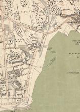
I believe this was the first generation of ferry pier at Hung Hom, but please let me know if there was any earlier one. It was off Winslow Street, in front of the junction with Gillies Avenue.
I first thought the pier went into operation in 1921, based on a request for tenders "for a licence for the exclusive maintenance of Ferry Services between Victoria, Hung Hom, Kowloon City, Saiwanho, and Shaukiwan." Tenders had to be submitted on or before 31 Dec 1920, and the licence would begin on 1st April 1921. Source: Item S.343 in the Government Gazette.
I skimmed the PWD annual reports from 1915 on, and the first mention of a Hung Hom Ferry Pier I found is in the report for 1921. Under Item 56, 'Dredging Foreshores', it says 1,993 cubic yards were removed from the Hung Hom Ferry Pier.
However Item 107 in the same report, 'Reconstruction of Ferry Piers' notes: "The expenditure during 1921 includes, in addition to the cost of new ferry piers, compensation in respect of Keng Shan and Hung Hom Piers and alterations to existing wooden piers." The mention of compensation makes me think the pier already existed in 1921, and the government bought it from the previous owner. The first map at http://www.hkmaps.hk/mapviewer.html that shows a pier here is the 'Map 1903.1', so that's the completion year I've guessed. 1921 may still be the first year that a ferry service operated from Hung Hom.
This site was reclaimed sometime in the late 1950s / early 1960s, and ferry services moved a short distance southeast to the two new piers in front of the bus terminus, one for North Point and one for Central. [Update: The area was reclaimed and the pier went out of use sometime in 1963-64, as described in Klaus's comment below.]
Corrections welcomed.
Photos that show this Place
Comments
Hung Hom Ferry Pier
Hi David,
I believe the older maps (the late 1950s) has it and the marker is approximately on Winslow & Gilles. The pier was still there until they started the reclaimation in the late 1960's. After the Hung Hom Raiway Terminus was completed, new peirs were built off the location of the present day foot bridge. I remember there were two piers. One for HYF and the other for Star Ferry.
The then HYF pier used a barge betwen the pier and the ferries for boarding. Star Ferry has their bording facilities built into the pier.
T
The reclamation in this area
The reclamation in this area is mentioned on page 232 of the government's Hong Kong 1962 book:
At Hung Hom work began on a further 2,800 feet of seawall which will complete the reclamation and increase its present size by a further 30 acres. The reclamation ultimately will be occupied by a new railway station and a marshalling yard to replace the present facilities at Tsim Sha Tsui, and new ferry piers will be constructed nearby.
Work on the reclamation was still underway in 1964, according to page 177 of Hong Kong 1964, though the section with the new piers was probably finished by then:
At Hung Hom another 2,00 feet of seawall was completed and work on a further extension of 1,200 feet of seawall closing the gap on the south of the reclamation was started; on completion, the land reclaimed will be available for the new railway station and marshalling yards.
re: Hung Hom Ferry Pier
Hi Thomas, our messages crossed over...
Yes, there's a good view of the pier on the 1956 map: https://gwulo.com/node/47421?a=1#17/22.30574/114.18379/Map_by_ESRI-1956…
I'm not sure this pier lasted until the late 1960s though? The quotes I just added from the year books suggest the reclamation was underway in the early 1960s, and the notes from Klaus at https://gwulo.com/comment/50588#comment-50588 mention the new piers in 1963.
1924
The pier is shown on the 1924 Kowloon map.
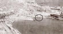
January 1963
The pier with a ferry, I think a Star Ferry, is visible. No sign of reclamation work here in January 1963.
The next aerial survey is from December 1964: Here the older pier is gone (reclaimed), and the two new one are there.
So the demolition of the older and construction of the new piers was between January 1963 and December 1964.
Thanks Klaus, that narrows it
Thanks Klaus, that narrows it down further.
You mentioned "No sign of reclamation work here in January 1963" - I think that line heading into the sea near the top of the 1963 photo is the new seawall.
Re: New sea wall
Hi There,
I believe we could use the buildings as landmarks. In the last photo the sea wall had been pushed outwards just past the first block, at around present day Whampao street/
T
Re: seawall
Hi David, my statement about reclamation meant the old shoreline. I must admit that I overlooked the straight line - pretty sure that it is the new seawall. Regards, Klaus
Hunghom to Wanchai pier
moved a short distance southeast to the two new piers in front of the bus terminus, one for North Point and one for Central.
In 1963, the two new Hunghom piers rather go to North Point and Wanchai. Here the 1963 news report about the new piers in Hunghom.
The Wanchai pier at the Gloucester-Tonnochy junction started service the same time in 1963. They added two new wings to the the old pier there. Left wing to Hunghom. Right wing to Kowloon City.
Here the 1963 news article about the Tonnochy pier:
By the way, a third pier going to Central was built in 1965 further south of the first two. A news article reported the new pier to Central was under construction in 1965:
An aereal picture showing all three piers together in 1965. From right to left, to North point, to Wanchai, to Central.
One interesting fact is that the Hunghom to Central line opened in 1965. In 1967 they stopped the service for reason they were not making money according to Star ferry company. They only restarted again after the new Hunghom train station was opened in 1975.
Re: Hung Hom ferry Piers
Hi simtang,
think your comments refer to the newer piers Former Hung Hom Ferry Pier (1979) for Hung Hom/North Point service [????- ] and Former Hung Hom Ferry Pier (1979) for Hung Hom/Central service [????- ].
Compare this 1963 photo to yours from 1965.
Regards, Klaus
hunghom piers
I never commented on the 1979 piers. The Hunghom-Central line started in 1965. My comment was "a third pier going to Central was built in 1965 further south of the first two. A news article reported the new pier to Central was under construction in 1965" The news article is in 香港工商日報, 1965-05-05 which reported the 1965 pier in Hunghom going to Central was under construction. Therefore the Hunghom-Central line started in 1965. In June 1967, they stopped the service. That pier next to the Wanchai pier was probably demolished by the time they restarted the Hunghom-Central line in 1975. Initially Star ferry Hunghom-Central line probably shared the YMT Wanchai pier. The 1979 Hunghom to Central pier is not the same as the 1965 pier as the latter had been demolished by that time.
https://mmis.hkpl.gov.hk/coverpage/-/coverpage/view?_coverpage_WAR_mmis…
Re: hunghom piers
I'm a bit confused now.
There was a first generation of piers located at the end of Gillies Avenue (c. 1903 to c. 1963).
There was a new (additional) pier from c. 1980 located where todays Metropolis Towers are. (demolished after reclamation works in about 1990)
The current generation from 1991 is located opposite Kerry Hotel Hong Kong.
So far I thought the piers at (todays) Hung Ling Street which I mentioned in my post were second generation, despite the attributed date 1979. Or was there another generation of Hung Hom Piers? If so, we should create places on Gwulo to show that.
hunghom to central
I guess I understand why people confused the Hunghom to Wanchai pier (1963-?) with the 1979 pier. The 1963 built Wanchai pier was never meant to be used for the Central line. It was just a temporary measure to use it for the Central line in 1975 until a new pier was ready.
For Hunghom to Central line:
The 1965 built Hunghom-Central pier is first generation. (1965-1967)
The 1963 built Wanchai pier is second generation. (1975-1988)
Then I lost track of the later generations.
There are two news articles explaining the situation in 1975-1976.
It explains that with the opening of the Hunghom train station, Star Ferry company was going to restart the Hunghom-Central line.
Initially the line would share the Hunghom pier which serviced Wanchai. YMT Ferry company would expand the Hunghom-North Point pier to accommodate both the Hunghom-North Point line and Hunghom-Wanchai line. In January 1976, the expansion had finished and the Hunghom-Central line would have exclusive use of the Wanchai pier.
hunghom to central
Here is another article I found which essentially confirmed what I said.
紅磡有長久的歷史,有不同類型的碼頭一點也不出奇....
1928年油麻地小輪開辦中區-九龍城-筲箕灣線,似乎是不停紅磡的,
那時都沒真正的碼頭..九龍城我估停龍津碼頭.....
我記得最少1949年的香港年鑑之類,已有提及紅磡有街渡(嘩啦嘩啦改裝的)
往來北角,當年最出名叫利安小輪的,曾經開過紅磡北角,北角至茶果嶺牛頭角,
甚至筲箕灣至茶果嶺牛頭角觀塘鯉魚門等線,是1963年前油麻地小輪得到
政府行東區線專利權前當地最著名的牌照船公司...那時紅磡碼頭採用機利士路
尾的地方,我估是公眾石階之類...
油麻地小輪於1963年接辦北角至紅磡,及新增灣仔至紅磡時,就採用機利士路伸
出的新填地用來建兩個碼頭來服務....1965年天星小輪再自建多一個新碼頭,
服務往來中環的航線,到1967年暴動"順勢停航"後停用,1975年重開線時,
是用了油麻地小輪的灣仔線碼頭,灣仔和北角共用碼碼頭至1979年在紅磡火車站
旁邊的新紅磡碼頭落成止,北角灣仔二線搬進去後,到80年代建紅磡貨場填海時,
灣仔北角二線搬去紅磡灣中心海旁,至1991年三線一併因填海搬去黃埔花園旁,
今日的紅磡碼頭止...
以上就是紅磡碼頭歷史...
https://www.hkitalk.net/HKiTalk2/thread-421517-1-1.html
I was wrong about the 1979 new pier. It actually was used for the North Point and Wanchai lines.
So I guess the Central line was still using the Wanchai pier in 1979. Correct me if I am wrong.
As the above article mentioned, the coastline at Whampoa Street was reclaimed in the 80s, the North Point and Wanchai lines moved from the 1979 built pier to the Hunghom Bay Centre seafront in 1988. In 1991, all 3 lines moved to Whampoa garden seafront.
The article is not accurate in saying only two lines moved to hunghom bay centre in 1988. All 3 lines moved there as confirmed by this map uploaded by Klaus found on Gwulo:
Turntable-Tsim Sha Tsui East,
The 1979 pier looks like this. It goes to North point and Wanchai. It belong to YMT. (forget the wrong title, it is actually Hunghom)
My 1965 photo shows 3 piers, the one on the left looks totally different. It was built in 1965. It goes to Central. It belongs to Star ferry.
Hung Hom Piers
Hopefully, things are getting clearer to me about the piers in Hung Hom.
The hong kong annual report for 1963 refers:
Ferry Services.
The Hongkong and Yaumati Ferry Company Ltd operates a fleet of 62 diesel-engined ferries. During the year four cross-harbour services were added bringing to 11 the total number.
These new services are the Wan Chai/Hung Hom, North Point/Hung Hom, North Point/Kowloon City and North Point/ Kwun Tong services. A Jubilee Street/Hung Hom service was operated by the company before the war but it was not until September 1963 when a seawall was built that the company resumed operations from Hung Hom.
The North Point/Hung Hom passenger service commenced on 1st September. The North Point/Kwun Tong service commenced on 1st November and is temporarily operating from the same berth as the North Point/Kowloon City service on the Hong Kong side. The routes inside the harbour are now between Wilmer Street, Rumsey Street, Jubilee Street, Stewart Road, Tonnochy Road and North Point on Hong Kong Island and Sham Shui Po, Mong Kok, Jordan Road, Hung Hom and Kowloon City and Kwun Tong on Kowloon peninsula.
These two piers should be at the location of Former Hung Hom Ferry Pier (1979) for Hung Hom/North Point service [????- ] (east one) and Former Hung Hom Ferry Pier (1979) for Hung Hom/Central service [????- ] (west one). If we delete "1979" and "Central" from the description, this should fit with the 1963 piers.
Let's move to the hong kong annual report for 1965:
The Star Ferry Company Limited is authorized by ordinance to run passenger ferry services across the harbour between Victoria City on Hong Kong Island and Tsim Sha Tsui on the southern tip of the Kowloon peninsula, and also between Victoria and Hung Hom on the eastern side of the peninsula. This latter service was introduced in June 1965.
This new (third) pier seems to be at the location of Former Hung Hom Ferry Pier (1979), new pier at the time [????- ]. Either the description is incorrect as the pier is older, or the new pier from 1979 is meant, then the location is incorrect (this is what I suppose). In the latter case, we need an additional place for the 1965 Hung Hom Pier (Star Ferry to Central).
Simtang, do you agree with this so far?
David and tngan, we probably need to rearrange the different Hung Hom Pier entries. And we should add the 1990's piers.
hunghom piers
Klaus:
I don't see anything inconsistent. The 1979 built Hunghom to North point and Wanchai pier could be at the same position as the 1965 built Hunghom to Central pier. Star ferry stopped the Central line in 1967 and the pier was subsequently demolished. In 1979 YMT could build that new pier anywhere south of the other two piers because that whole stretch there was totally empty. As the above news report (工商晚報, 1975-11-16 The Kung Sheung Evening News) indicates, that 1965 pier was no longer there in 1975 when star ferry restarted the Central line, they had to share the Wanchai pier (the second one from the right) with YMT for 2 months until YMT was ready to move their Wanchai line to the first pier from the right. In summary,
1 the first pier from the right in my 1965 photo was for north point line (1963-1976), and then for north point and Wanchai lines after some reconstruction (1976-1979)
2 the second pier from the right in my 1965 photo was for Wanchai line (1963-1976), and then for Central line (1976-1988).
3 the third pier from the right in my 1965 photo was for Central line (1965-1967) and demolished not long after that.
Hope it is clear.
A new Hunghom pier going to Central was under construction in 1965. The 1963 piers were going to North point and Wanchai. No way it can be fake. Another way to check is 香港年鑑 in that period of time. They have the maps of Hunghom all showing the middle of the 3 piers was going to Wanchai from 1963 to 1976. As an example, this is a 1967 map of Hunghom which shows the usage of the 3 piers in 1967. I myself was a frequent user of the Wanchai pier.
================================================================
It is a map of 1969. The Central line is gone. The pier apparently was not yet demolished.
======================================
The facts are all on record. In case of doubt, here is the news article I posted above. You can check it yourself.
香港工商日報, 1965-05-05
https://mmis.hkpl.gov.hk/coverpage/-/coverpage/view?_coverpage_WAR_mmis…
where was the pier in 1949
This is the air view in 1949 of South Gilles Road from HKmapviewer. For whatever reason, the pier at Gilles Road has disappeared. But it seems to have come back in the early 50s according to a news article which mentioned a pier existed at the Winslow-Gilles junction in 1957.
https://mmis.hkpl.gov.hk/coverpage/-/coverpage/view?_coverpage_WAR_mmis…
One can see clearly the nullah along Gilles road which reached as far as the waterfront. One also see the plot between Gilles road and Whampoa Dock was almost empty at that time. The Whampoa street didn't even exist then.
re: where was the pier in 1949
I remember reading that Hung Hom was bombed by the Americans in WW2, so I wonder if the pier was damaged or destroyed then?