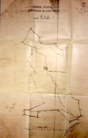
I find the boundary plan of Pinewood & High West finally! It spent me almost half year to dig in folder at GRS!
I get it today, [Pinewood & High West] as we guess, it have 30 War deparment boundary stone!
now we get 12 of those WDBS#2, WDBS#3,WDBS#4, WDBS#6, WDBS#7, WDBS#8, WDBS#9, WDBS#10, WDBS#11, WDBS#14, WDBS#18, WDBS#26!
if you can find more of them, May I have your finding of location and Picture share! have fun!

Well done, it's good to see
Well done, it's good to see the official layout at last!
we find 19 WDBS at this zone by this plan
We discover 4 more WDBS today 20, 21 22 and 25 today(12/8)!
Good work, and thanks for
Good work, and thanks for adding the Places and photos.
Were they hidden away in the bushes, or is there any path to them?
A couple of tips to make your new pages easier for other readers to discover:
WE get 25 out of 30 pinewood/highwest boundary stones
After few field trip days, now we get 25 War Department boundary stones at pinewood/high west site!
I would try to input all War Department boundary stones and photo!
some easy to access, but some not easy!
please wait for update!