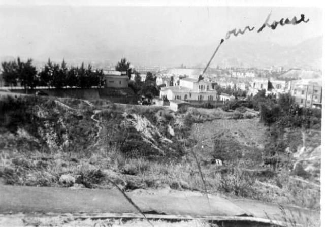
Photo courtesy of Bruce Gordon. He lived there with his family in 1949.
Thanks to Bruce, and to Vanessa for sending it.
Does anyone know where "48, Ho Man Tin Hill Road" address would be today? I can't find it in the government map website.
Regards, David
Date picture taken
1949
Gallery
Comments
Ho Man Tin Street?
Initially I was gonna guess that we are looking towards the east from the hill that is currently Oi Man Estate/Chun Man Court. But then I saw the hills in the background which made me think we are looking northerly. (BTW, is one of those hills in the background the one with the "checkerboard" for airplane landing purposes?)
If so, could the ditch below is present-day Wylie Road / East Rail line, so this could actually be Ho Man Tin Street, which leads up to Ho Man Tin Hill Road? FYI, No. 42-50 Ho Man Tin Street is now called Manchester Court (built in 1990).
re: Ho Man Tin Street?
Thanks for the extra information. I don't know that area well enough to add anything, but here are some photos showing that area that might help.
An aerial view of the area in 1964:
Looking northeast from Kings Park in the 1950s:
And looking north (railway line on the left) in the late 1940s:
Regards, David
Ho Man Tin
To compliment the aerial view of the same area.
Homantin Hill Road
The building number seems to be a bit high. Living on that road from the early 1970s onwards I do not recall such a high number. Especially as the road would have been much shorter in the period of the picture. The road originally dropped down into Nairn Road near the loop road into petrol stations, ie Princess Margaret Road, and was extended down to exit into Wylie Road later when the villas/mansions started to be redeveloped. However, the whole area has changed vastly over the years, except possibly Homantin Street running by the railway.
Lost...
Oh now I'm lost... is that Princess Margaret Road/Nairn Road or Ho Man Tin Street below we are looking at? Or could this be some other hill? Kadoorie Hill?
ho man Tin Hill
Chi Man Road and nirns Road became Pincess Margaret road. Kadoorie Ave is to the top of the map
The photo
I was talking about the ditch/road below the house in the photo.... I wasn't sure which road it should be, or even if it should be some other hill in the area.
Re: 48 Ho Man Tin Hill Road
Hi David,
You likely have to lookup some older maps of the 1950's. Maybe the house was not on the road side but the numbering was adhered to Ho Man Tin Hill Road?
Thanks & Best Regards,
T
Here's a map of the area in
Here's a map of the area in 1956, but no road numbers unfortunately:
http://gwulo.com/map-of-places#17/22.31592/114.17643/Map_by_ESRI-1956_K…
Re: 48 Ho Man Tin Hill Road
I live on Ho Man Tin Street since childhood. I'm so pleased to see this discussion and learn about the history of the neighbourhood where I grew up.
After studying the photos and maps, I have a different idea. The place in David's photo looks like the intersection of Ho Man Tin Hill Road and the dead end road near the top of the hill. The photo might have been taken from the other side of Princess Margaret Road (Nairn Road). I suspect the house in the photo is located at where Man Tin Court is today, which is 6 Ho Man Tin Hill Road. And the trees on the left is where later became the staff quarters of CLP Power (demolished, now 15 Homantin Hill)
I guess the street number could have meant "4-8 Ho Man Tin Hill Road" instead of 48?
ho man tin street
Do you know of any Portuguese family living on Ho Man Tin Street? I have been trying to get re-connected with my childhood Portuguese friends, siblings Tom, Marilyn, David and Mary. Unfortunately I don't know their family name. In the 60's they lived on the left hand side of the street not far before it turns up hill into Ho Man Tin Hill Road.
Possible match?
Hello David L,
I'm of a younger generation of Macanese heritage so wouldn't have known those individuals above personally, but am very interested in Macanese genealogy. There is a huge Macanese family tree currently managed by Robert Leitao in Ancestry. I tried to look for "Marilyn" (as this is the more unusual name out of the 4 you gave). I did find a possible match of a set of siblings:
Derek Turner
Marilyn Turner
David Turner
Mary Turner
And their parents were Harold Joseph Turner and Maria Assuncao "Marie" Pereira (mother being Portuguese/Macanese heritage I suppose)
I think worth getting in touch with Robert Leitao - he is very helpful and probably can connect you in some way
Robert provided his contact here on Gwulo:
Robert Francis Leitao on Facebook
leitao66@gmail.com
2. Search these resources that may have information about the person | Gwulo: Old Hong Kong
Best wishes
Vanessa
flipped?
looking at the original photo at the top, I think it may be flipped. The background suggests looking east towards Lei yue mun, so perhaps if it was reversed it might be easier to pinpoint the house location.
Re: Flipped?
Hi Phil,
I captured and flipped horizontally and guess I saw the checkerboard hill, almost on a straightline where the photographer was standing with the house in between.
May have to get the flipped image again later because the other computer just crashed.
T
Checkerboard Hill?
I'm not sure checkerboard hill makes sense. If the image is of Ho Man Tin area, then Checkerbaord Hill is far too north to show up between there and what I think is East Kowloon. Perhaps the shaved slopes were part of one of the other hills around where Ho Man Tin east reservoir is today? This would put the house much further south close to Oi man estate or King's Park. I'm just guessing at the moment as I can't see anything that really helps.
Re: Flipped?
Hi Phil,
Well, the background is too fuzzy. I could bearly make out some ridge lines but they are just too faint to compare with anything. I'll see if I could use a bigger monitor to view your flipped photo later.
T
image
yes, unfortunately I'm not even 100% sure about the image flip, but it looks plausible. The faint slope in the left background looks like it is the eastern slope of Tai Sheung Tok.
Re: Flipped?
Hi Phil,
Now that HKMS 2.0 is up again, I guess I would try aerial photos tomorrow instead.
T
Re: Original Photo
As the original photo is not clear, I am not sure if one is looking at the hill in the distance near Nga Tsin Wai Road which was removed for the construction of the reclaimed runway at Kai Tak. An aerial photo of the area appears here Kowloon Hospital on the right?
Hello Vanessaf
Hello Vanessaf
Thank you for your response and the info. Your help is much appreciated. I'll definitely give Robert Leitao a try.
regards and thanks again,
David L
DavidL
I hope you will find your childhood buddies, David L!
Best wishes
Vanessa
ho man tin street
Hello David:
I lived at 25 Ho Man Tin Street, ground floor, for the first ten years of my life. I believe you are speaking of my friend Marilyn, as the location of where they lived, and the names of her siblings (other than Tom, which was Derek) fit. Marilyn was my first friend, and we remain friends to this day. I am not sure if she accesses gwulo, but I sent her your request. I have not heard from her yet. Maybe she has already contacted you ?
Did you live on Ho Man Tin Street as well ?
old friends on Homantin Street
Hello Edwina,
Thank you for responding. I lived on Waterloo Road, not far from where you lived. I was friends with Marilyn's younger brother David. Marilyn, David, her little sister Mary and I used to go up Homantin Hill Road to play on the hill top. They lived on the second or maybe top floor of a two or three story building on Homantin Street. There was a built-in fish tank right above the entrance to her building or was it the building next door, I don't quite remember. I believe Marilyn went to Mary Knoll, David and Mary went to St. Teresa. They have an older brother Tom or maybe Derek whom I only met once went to St Francis I believe. I really hope this is the same Marilyn we are talking about.
best regards, David L
11 Ho Man Tin. Hyndmans & Sequeiras
Fascinating to see these pictures and read the comments. According to the Jury List, Alberto Herculano Hyndman lived at 11 Ho Man Tin in the late 1930 until the war. After the war, his brother Rafael Hyndman with his family. Two sons Fred and Henrique lived at that address and in the unit right next door, my parents, Francis and Terry Sequeira and my two older brothers and me after my birth in 1950. We left for the USA in 1956. Was hoping and wondering if anyone knew the Hyndman's prior and after the war and my parents after the war. Prior to the war, the Sequeiras owned a home on Soares St. the home was sold just at the beginning of the war. After the war, my grandparents moved to 500 Cumberland.
Was also wondering if anyone can identify which building No. 11 Ho Man Tin was in the two pictures taken in the 1940's
Francesca Gonsalves Sequeira Loftis
I've made a page for number…
I've made a page for number 11 at https://gwulo.com/node/60814