I believe this structure is shown in GeoInfo Map. Despite living in the area since 1994, I did not wander up there. I had been to the upper platform though.
I guess one could scramble down from the top using the dotted line footpath, which is likely easier than what you did from the bottom.
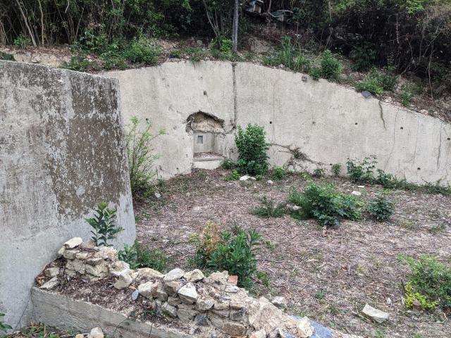
This is probably the cutting shown on the map, but none of the other structures or the footpath from the upper platform is shown. I suspect there are stairs somewhere buried under the soil subsistence.
The site is pristine, lacking the usual rubbish of other wartime ruins. I will probably head up on the weekend to do some cleaning.
Thanks very much for the high-res link tngan. Looks like we have a few promising sites (outlined in blue). That's definitely the lower battery platform with three shelters (outlined in red) on this crude superimposition.
Some of them may have already been shaved away owing to slope maintenance works in past decades, as show in GeoInfo Maps. Even if some of the structures are still there, they might have been buried under rubbles. On the other hand that part of the slopes are much over grown, even more severe then the way you scramble up from street level at the DEL.
The northern most area you highlighted in blue is very likely a fenced off area now. I remember I have climbed up to the fence more than a decade ago and saw only some sort of a reinforced terraced slopes there. No ruins of any sort whatsoever. That is about a bit more than 20 metres from the pavilion. Couldn't remember exactly how far. If my memory is still intact the fence is quite tall and have barbs up there so I would not recommend going over it.
T
ps. Found another aerial photo dated 1963. I believe both of your highlights in blue are already gone. The other one appeared to be in the location of the pavilion nowadays. If one could dig into the ground we may find the foundations of the structures, but that would be an offence.
The two long rectangluar platforms seemed to have survived together with part of the concrete walls about a foot thick, however.
It certainly seems that way. I was following the footpath above the football pitch about two weeks back (trying to find that damn pillbox) and most of the slope had been concreted with drainage trenches built in. Still, the upper area may have some surviving remains.
Just noticed the two white boxes at the upper edge of the photo. I know where those boxes are. So it is actually very close to the upper platform. If I am 30 years younger I may have risked jumping down from the edge.
Anyway, I suspect those two boxes are where the bees coming from.
Comments
Re, Aberdeen Battery Lower Platform
Hi There,
I believe this structure is shown in GeoInfo Map. Despite living in the area since 1994, I did not wander up there. I had been to the upper platform though.
I guess one could scramble down from the top using the dotted line footpath, which is likely easier than what you did from the bottom.
T
GeoInfo Map
Hi tngan,
This is probably the cutting shown on the map, but none of the other structures or the footpath from the upper platform is shown. I suspect there are stairs somewhere buried under the soil subsistence.
The site is pristine, lacking the usual rubbish of other wartime ruins. I will probably head up on the weekend to do some cleaning.
Re: GeoInfo Map
Hi There,
Now that HKMS 2.0 is up and running again, I looked up aerial photos and this one seems to be very clear:
https://www.hkmapservice.gov.hk/OneStopSystem/map-search/getPreviewFile?itemId=DAP&sheetNo=06093
The site is quite extensive. The development may have destroyed some of them over the decades though.
T
New Targets
Thanks very much for the high-res link tngan. Looks like we have a few promising sites (outlined in blue). That's definitely the lower battery platform with three shelters (outlined in red) on this crude superimposition.
Re: New Targets
Hi There,
Some of them may have already been shaved away owing to slope maintenance works in past decades, as show in GeoInfo Maps. Even if some of the structures are still there, they might have been buried under rubbles. On the other hand that part of the slopes are much over grown, even more severe then the way you scramble up from street level at the DEL.
The northern most area you highlighted in blue is very likely a fenced off area now. I remember I have climbed up to the fence more than a decade ago and saw only some sort of a reinforced terraced slopes there. No ruins of any sort whatsoever. That is about a bit more than 20 metres from the pavilion. Couldn't remember exactly how far. If my memory is still intact the fence is quite tall and have barbs up there so I would not recommend going over it.
T
ps. Found another aerial photo dated 1963. I believe both of your highlights in blue are already gone. The other one appeared to be in the location of the pavilion nowadays. If one could dig into the ground we may find the foundations of the structures, but that would be an offence.
The two long rectangluar platforms seemed to have survived together with part of the concrete walls about a foot thick, however.
https://www.hkmapservice.gov.hk/OneStopSystem/map-search/getPreviewFile?itemId=DAP&sheetNo=1963-7494
Slope Displacement
It certainly seems that way. I was following the footpath above the football pitch about two weeks back (trying to find that damn pillbox) and most of the slope had been concreted with drainage trenches built in. Still, the upper area may have some surviving remains.
Re: Gun Emplacement Rear Wall
Hi There,
Just noticed the two white boxes at the upper edge of the photo. I know where those boxes are. So it is actually very close to the upper platform. If I am 30 years younger I may have risked jumping down from the edge.
Anyway, I suspect those two boxes are where the bees coming from.
T