This week's story begins like many on Gwulo: seeing something new on a walk and thinking, "That's a bit odd ..."
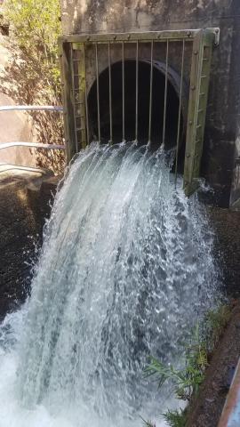
We'd just walked uphill from the lower Shing Mun Reservoir, and noticed there was a large metal pipe running alongside the path. When the path levelled out the pipe ended abruptly, pouring water out into a concrete channel.
The channel is a short one, soon disappearing into a tunnel in the hillside.
It seems odd to have a pipe pouring water into a channel like this - why not just continue the pipeline? And where does the water go to after it enters the tunnel?
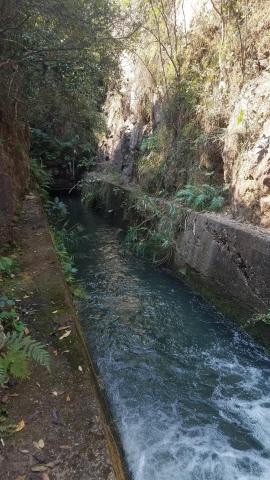
The next part of the walk followed what had looked like a catchwater on the map, but it raised more questions. It must have taken significant work to build the catchwater, so why has it been allowed to fill up with the sand and gravel that had washed in? And why was there a concrete barrier across it, separating it from the channel to the tunnel?
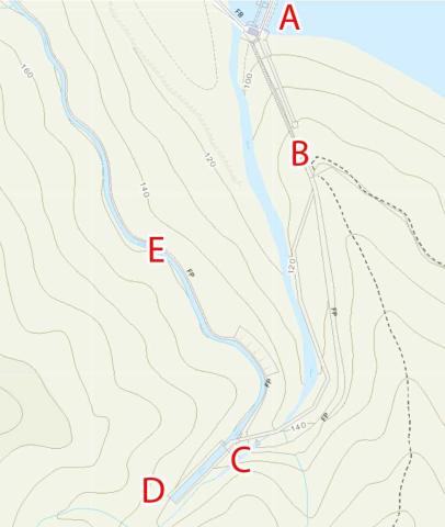
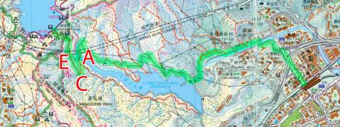
I turned to the modern map on the government's HKMS website to see if it has any answers:
We'd crossed the lower Shing Mun Reservoir via the footbridge marked (A). The water pipe also crosses the reservoir at that point, then the footpath and pipe run up the hill together (B). The pipe ends at (C), and the channel enters the tunnel at (D). The derelict catchwater we continued along is marked (E).
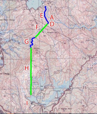
The map doesn't show where the tunnel leads to after (D), but I'm sure the government maps used to show the route of tunnels. I turned to the excellent collection of older maps on the Hong Kong Maps website and yes, the tunnel is clearly shown on the older maps such as this one from 1987.
It shows that the water runs southwest from (D) through the tunnel (F) under Smugglers Ridge, out in to the open again at (G), then back into a longer tunnel (H) that runs south under Golden Hill. The destination is the Kowloon Service Reservoir at (I). The map also shows that the footbridge and pipeline at (A) were already there in 1987.
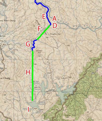
An older map on the site shows how things looked 30 years earlier, in 1957.
This time there's no sign of the footbridge or pipeline at (A), so we know they're relatively recent additions, and not what the tunnels were built for originally. The lower Shing Mun Reservoir hadn't been built, either, though everything else looks much the same. One small difference is that this map gives names to three of the sections:
- (F) North Tunnel
- (G) South Conduit
- (H) South Tunnel
They don't give (E) a name, but if it followed the above pattern it would be the North Conduit. I note the mapmakers call it a Conduit, carrying water, rather than a Catchwater, collecting rain that runs down the hillside. This conduit begins at the dam of the main Shing Mun reservoir, so were the tunnels and conduits built to carry the water from that reservoir?
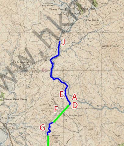
Maybe not, as turning the clock back again, this map from 1928 shows the tunnels were already in place before there was any reservoir at Shing Mun.
The conduit (E) continues off the top of this part of the map, so lets follow it back to where it begins.
It runs along the side of the valley, running parallel to the Shing Mun River. The conduit begins at a small dam across the river (J), just north of Pineapple Pass. This map gives it the label 'Open Conduit'.
So, we know the tunnels and conduits were all in place before the reservoirs were built, and were already here by 1928. What were they built for?
Maps won't give us the detail I'm looking for, instead we'll need some documents: it's time to start typing likely search terms into the Hong Kong Government Records Online (HKGRO) website. No results for north tunnel, but a search for south tunnel returns one result, and it looks like a good one:
- GA 1924 (suppl) no.158: Tenders invited for North and South Tunnels, South Conduit and Contingent Works
It describes the tender as “Shing Mun Scheme - First Section - Tender for North and South Tunnels, South Conduit and Contingent Works”, and says it is for "the driving and necessary lining of two tunnels, approximately 2,160 feet and 4,680 feet in length through Smugglers’ Ridge and Golden Hill respectively, the Construction of an open conduit approximately 2,000 feet in length".
So we're looking for information about the Shing Mun Scheme, in the early 1920s. Although the HKGRO search only returned one match, I guess it has more information available. The old documents on that site aren't all in great shape, so often the scanned copies aren't clear enough for the HKGRO computer to recognise all their words. Instead we'll need to read through them manually, to see what we can find.
Large construction projects were organised by the Public Works Department (PWD), so their annual reports are a good place to look.
As I hoped, the PWD reports for 1922 and 1923 both mention the project, but only have a brief mention of preparations being made - it's the 1924 report that spills the beans. It describes a grand scheme, to be built in several phases (the 1924 report calls them 'sections'). The first phase included the work shown on the 1928 map, starting by intercepting the Shing Mun River, and diverting its water via the conduits and tunnels to the Kowloon Service Reservoir. This wasn't just being built for Kowloon's benefit though. The water would continue via a series of pipelines and reservoirs to Tsim Sha Tsui, through the first cross-harbour pipeline, then uphill to the last reservoir in the chain: a new reservoir to be built in the Botanical Gardens, conveniently situated just above the Governor's Residence. The population on Hong Kong island had outgrown the island's reservoirs, so this was a way to bring them additional supplies of drinking water.
The second phase would see a large new reservoir built in the Shing Mun Valley. Most of the northern conduit would then vanish from sight under the waters of the new reservoir, but the last section (E) would still be used. It would deliver the water from the new reservoir into the tunnel and on to the Kowloon Service Reservoir and beyond.
Returning to those initial questions, we now know where the tunnel leads to, and why the derelict conduit - not catchwater - was originally built: first the conduit delivered water from the Shing Mun River via the tunnels to the new service reservoir, then after the Shing Mun Reservoir was built it carried water from there instead. At some point another route was developed to carry the water away from the main reservoir, meaning the conduit was no longer needed and was allowed to fall into disrepair. That could have meant the tunnels would also become unused, but instead they had a new lease of life when the later pipeline was built that still pours water into them today.
(If we have any water experts reading, do you know the source of the water we saw pouring out of the pipe? And does it run continuously, or only as needed? The day I took the photos was the third time we'd walked past there, but I don't remember seeing water pouring out on the first and second visits. I'm not sure if that's an accurate memory though, or if I just wasn't paying attention on those earlier visits.)
More waterworks:
- The original plans for the Shing Mun Valley Scheme are described in item 213 of the PWD's Annual Report for 1924.
- The Shing Mun Valley Scheme was the latest round in a long-running competition between the PWD and Hong Kong's thirsty and ever-growing population: the PWD would finish a new reservoir, providing plenty of water for all. Then the population would surge and soon there would be water shortages again. The PWD would start work on the next reservoir, and the cycle would repeat.
In 1929, Governor Clementi gave a long speech to Legco that includes a summary of the history of Hong Kong's water supply up to that date, and ends with the latest plans for the Shing Mun Valley Scheme. It's a good read for an overview of Hong Kong's early struggles to provide water for all. - See Places on Gwulo tagged water supply, either on a map, or as a list.
More exploring:
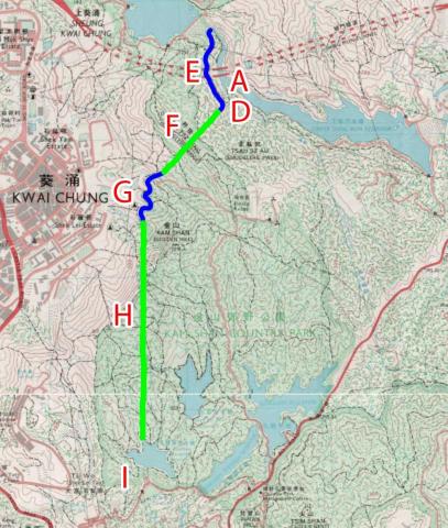
- If you'd like to visit the pipe, tunnel, and disused conduit described above, I've highlighted the route we walked in green, on this copy of the North East & Central NT sheet of the Countryside Series maps (click for a larger copy of the image). We started from Tai Wai station at the right, then walked along the north shore of the lower Shing Mun Reservoir. We crossed the footbridge (A), climbed up the first staircase to the end of the pipe (C), then followed the disused conduit (E) until we came to a second set of steps that brought us up to the top of the main reservoir.
- There are several options for where to walk next after reaching the main reservoir. I recommend following section six of the Maclehose Trail as it takes you past the Shing Mun Redoubt, a wartime relic from WW2 with tunnels that are easy to explore.
More stories:
- There are many more stories of old Hong Kong in my series of books.
Comments
The Hong Kong Telegraph 1923
The front page of the the Hong Kong Telegraph on 1923-12-01 has mentioned the Shing Mun Valley Scheme, "Telegraph" Special, taking the peak of Tai Mo Shan as the centre, using purely gravitation system without using any pumping to collect water. "....A great deal of survey work has been completed and not only have the sites of several of the various reservoirs been surveyed but the lines of the conduits, tunnels, etc., have been mapped out....". "...when completed, should solve the problem of the colony's water supply for very many years to come."
Our water supply, The Shing Mun Valley Scheme "Telegraph" Special Page 1 and 13.
Shing Mun Valley Scheme
David
Did you miss seeing Paul Zimmerman's Designing Hong Kong newsletter concerning this water works scheme and others earlier this year? Paul contacted me after reading a letter I wrote to the "South China Morning Post:" on 1st January this year . They published it captioned as " Hong Kong officials may read 1934 journal for clues to water works history"
I had highlighted that there were a series of articles about water works in Hong Kong witten by Professor C. A Middleton-Smith ,who was Dean of the Engineering faculty of HKU in ther 1920s-1930s. These were published in The Far Eastern Review which forms part of my own collection concentrating on early railway construction in China .
Paul requested access to my collection to make scans of all the articles, which he has subsequently published on his "Designing Hong Kong" Website. I haven't checked yet, but I seem to recall reading about the construction of tunnels , catchment channels and culverts etc which sound similar to those you are describing above .
You may access these extracted articles at : Water Supply in Hong Kong – The Far Eastern Review 1927 – 1934 and if you need any enhanced ,higher resolution photograohs of any particular images you may contact me directly so I can scan them for you.
This is a map showing the Shing Mun Valley Scheme & Pipe Line from the early 1930s. The covered reservoir near Shek Kip Mei which was recently "rediscovered", appears to be marked on this map as a "Water Supply Tank (Covered)" . I think I have the right spot .
Interesting article in Hong Kong Daily Press 1926
re: Shing Mun Valley Scheme
Herman and Chinarail,
Thank you very much for the additional information.
I also heard from Tymon Mellor, noting he's written in depth on this subject:
Regards, David