Current condition
Demolished / No longer exists
Date completed
(Day & Month are approximate.)
Date closed / demolished
(Day, Month, & Year are approximate.)
Position of marker is approximate.
Photos that show this Place
1880s
1893
1890s
Comments
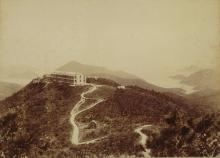
I think this is the Military
I think this is the Military Sanitarium that was at Mansfield Road:
Military Sanitarium, 504 The Peak
Hi Herostratus,
I think you're absolutely correct. Good find. I hadn't seen a photo of this building before.
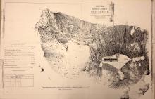
Reasons for agreeing with your conclusion are, firstly, the building in your pic is roughly the same irregular shape as the outline of the Sanitarium on the 1924 map. Secondly, here's a photo taken from near the junction of Peak and Guildford Roads a few years ago.
By comparing the two photos, particularly the relative positions of Brick Hill and Middle Island, it's possible to conclude;
- they were taken from similar positions with your photo taken from a position a few hundred meters further west along Peak Road.
- the Sanatarium stood on the site now occupied by Mansfield Road Government Quarters.
Both the 1909 (https://gwulo.com/atom/14774) and 1912 (https://gwulo.com/atom/21978) maps mark the Sanatarium as a cross-shaped building - quite different to its shape marked in the 1924 map. Perhaps the earlier building was expanded, or demolished and replaced by a new one, sometime between 1912 and 1924?
Demolition date may have been before WWII as I would expect to be able to see the Sanatarium had it been standing in December 1941 when the following photo was taken.
More speculatively, I wonder if the light coloured patch of ground on the left side of the following pic was the cleared site of the Sanitarium? The photo is tentatively dated pre-1940.
Dates for Military Sanatorium
The original Sanitarium was built in 1883. However the site proved to be extremely unhealthy and malaria ridden -the area was used in the 1901 medical report to illustrate the futility in eradicating malarial risks in HK. At some point either 1893 or 1907 the building was expanded (I lean towards the latter date) A 'reoccupation' was noted in a 1914 report having taken place recently. The site was definitely cleared before WW2, likely soon after the damage in the 1923 Typhoon.
The Typhoon which occurred on August 18th was responsible for damage to house property in the colony....The peak district suffered much more than the lower levels, roofs being torn off, and windows blown in. The Military Sanatorium was partially destroyed
1923 PWD Report
15. The Wong Nei Chong Battery site and the Sanitarium Barracks Officers Quarters were transferred by the Military Authorities to the Colonial Government, the former being credited with the sums of $963.17 and $20,0000 in respect thereof in the Military Lands account
1927 PWD Report
66. During the year sketch plans were prepared for a new Government House on the site of the Old Military Sanatorium near Magazine Gap
1931 PWD Report
Military Sanitarium
I was interested to see the entry on the Sanitorium on the peak, my own interest being the Army Medical Services in Hong Kong.
I have looked back through the copies I hold of the Annual Report on the Health of the Army and the section that deals with China and found the following entries about the sanitorium.
1882 Sanatorium above Wanchai Gap. One block of barracks completed but not yet occupied. (Note the spelling of Sanatorium)
1883 Sanitorium was completed and was occupied for the first time in July. (Again note spelling)
1887 Hospital accommodation insufficient during severe hot weather so convalescent patients transferred to Peak ‘where residence proved decidedly beneficial’.
1893 Water laid on from Colonial main. New verandah on South side erected
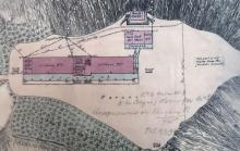
The plan of the Military Sanitarium
This area in the 1930s & 40s
A couple of mentions in documents held at the UK National Archives:
WO 106/2379 HK Interim Defence Plan.
(Printed in 1939 as a quick response to The New Policy of 1938).
Under Artillery, West Group: Sanitarium. 3.7” How. 2 Mtn Bty. (It gives a grid reference with the old grid used prior to the war. The map of the time which I have is of a scale that doesn’t give great accuracy, but puts that position in an area along what is now Guildford Road, so it appears to be the same place).
WO 172/1687 War Diary Island East Group RA.
19th Dec. Mobile Artillery at dawn: 6” Howitzer x 2. Sanitarium.
At surrender: 4.5” Howitzer x 2. (1 OOA). That’s army speak for out of action for some reason. This document does have some conflicting details with guns and places in other areas, but those seem pretty specific.
As a planned position it would have probably been a cleared flat area, possibly with small magazines and also shelters for gun crews, as seen at other similar battery positions. The clear area would align with the photo on Gwulo. From that I guess I could say the Sanitarium was demolished before 1939.