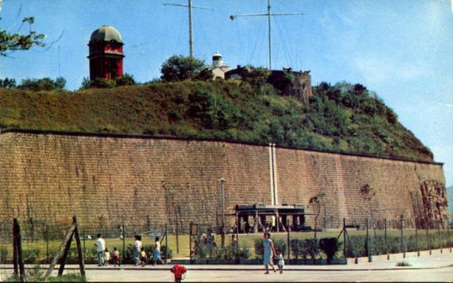
In many photos of Signal Hill after the 1930s, a vertical double-line can be seen on the stone wall facing the harbour as shown in this photo. Others include:
One immediate thought is the Hong Kong meridian, with the markers recently re-discovered by Stephen Davies, myself and Willie Yip (https://gwulo.com/node/30722). However, the double-line was 30-40 metres east of the meridian. More interestingly, a couple of photos (including this one) show two more fainted lines co-existing with the clearer double-line, it seems that the location of the double-line might have changed with time, with a new one replacing old fainted ones:
If it helps, the earliest dated photo I have seen of the double vertical lines is from 1932, i.e. about the same time the Middle Road Playground/Park came into existence. I note in the 1930s, the original vertical lines were to the east of the Children's Pavilion and there was a small white structure at the top end of the cliff wall as seen below.
Excellent and correct, impressive as usual! Water gushing down the double lines during heavy rain, as witnessed by OldTimer. I have never been close enough to see it, but still think it is a small channel with the size adequate to convey normal runoff without being visible from the road. The fact that it was marked with a different colour could have meant also for another purpose. Regards.
On the larger photo on flickr, a contributor had mentioned that the "characteristic black-on-white strip was painted for the attention of sailing vessels in the Harbour." Perhaps the Marine Department may hold such information.
Incidentally, Mr Ma Koon-yiu forwarded to me Government Gazette No.484 dated 21 August 1924, which declared that a new Cable Reserve was established between the City of Victoria and the South end of Kowloon Peninsula and such Cable Reserve was declared a Prohibited Anchorage and no ship, junk or other craft of any description shall anchor within the Boundaries of such Cable Reserve. It went on defining the Boundaries of Cable Reserve with one of them being "On the East - By a line from the Time Ball Tower (at Kowloon) 222 degrees to the Cenotaph (Victoria)".
This sounds correct. When a restricted area is marked by points on opposite sides of the harbour, it is difficult for a ship to know exactly when it crosses the line. But the white marks on the same side of the harbour as the Tower would enable the ship to see exactly when they were in line, and hence when the boundary was crossed.
Leading marks like this are still widely used to indicate undersea cable areas, the ends of a measured mile for ships undertaking speed trials, and a safe bearing for ships approaching the coast and wishing to avoid shallow patches etc.
My first thought was it is a meridian marker, quickly discounted before seeing the previous comments. My second thought, however, is that it may yet be a navigational reference aid - as an indicator of true north when the centre of the lines is lined up with the top of the tower. Vessels can then carry out a quick compass calibration check.
The 1960 harbour chart shows the cable exclusion zone marked by beacons, with no reference to Signal Hill, so you may be correct. However, they would not need repainting very often because magnetic north moves very slowly in HK - three degrees in the past 60 years if my calculations are correct (which is not guaranteed).
Reviewed the cable reserve. Although established in 1924, there was no noticeable markings on Signal Hill cliff face at the time or when the additional floor/level was added to the Timeball Tower in 1928. There were two accidents of note in 1924 and 1925 involving vessels and their anchors affecting the telephone and telegraphic cables in the cable reserve area. However, no mention was made of markings on Signal Hill.
The magnetic variation of Hong Kong has changed little over the years. May not be marine or nautical related as the painting of the vertical lines would have been noted or recorded by the Harbour Department/Marine Department.
It seems the painting of the vertical lines continued into the 1960s/70s or later. So what is actually the feature on the cliff wall?
I can't imagine that the white lines are any nautical signs. If you look at the photo below, you will see that Holt's Wharf completely blocks the view from the harbour.
Comments
Double-line on Stone Wall of Signal Hill
In many photos of Signal Hill after the 1930s, a vertical double-line can be seen on the stone wall facing the harbour as shown in this photo. Others include:
https://gwulo.com/atom/24858
https://gwulo.com/atom/23813
https://gwulo.com/atom/13744
One immediate thought is the Hong Kong meridian, with the markers recently re-discovered by Stephen Davies, myself and Willie Yip (https://gwulo.com/node/30722). However, the double-line was 30-40 metres east of the meridian. More interestingly, a couple of photos (including this one) show two more fainted lines co-existing with the clearer double-line, it seems that the location of the double-line might have changed with time, with a new one replacing old fainted ones:
https://gwulo.com/atom/22430
https://gwulo.com/atom/22431
https://gwulo.com/atom/23155
So the questions are: What was the purpose of the double-line? Why did its location apparently change with time?
After some discussions, Stephen Davies suggests several possibilities:
1) a marker for an underwater obstruction like a pipeline;
2) a marker for the eastern edge of the naval anchorage;
3) a marker for when to make gun salutes.
Thoughts are welcome.
- CM Shun
Re: Vertical Double-White Lines
If it helps, the earliest dated photo I have seen of the double vertical lines is from 1932, i.e. about the same time the Middle Road Playground/Park came into existence. I note in the 1930s, the original vertical lines were to the east of the Children's Pavilion and there was a small white structure at the top end of the cliff wall as seen below.
1950s Middle Road Children's Playground
May have been a vertical water channel.
Signal Hill
Excellent and correct, impressive as usual! Water gushing down the double lines during heavy rain, as witnessed by OldTimer. I have never been close enough to see it, but still think it is a small channel with the size adequate to convey normal runoff without being visible from the road. The fact that it was marked with a different colour could have meant also for another purpose. Regards.
1987 Signal Hill
On the larger photo on flickr, a contributor had mentioned that the "characteristic black-on-white strip was painted for the attention of sailing vessels in the Harbour." Perhaps the Marine Department may hold such information.
Double-line a boundary of Cable Reserve?
Incidentally, Mr Ma Koon-yiu forwarded to me Government Gazette No.484 dated 21 August 1924, which declared that a new Cable Reserve was established between the City of Victoria and the South end of Kowloon Peninsula and such Cable Reserve was declared a Prohibited Anchorage and no ship, junk or other craft of any description shall anchor within the Boundaries of such Cable Reserve. It went on defining the Boundaries of Cable Reserve with one of them being "On the East - By a line from the Time Ball Tower (at Kowloon) 222 degrees to the Cenotaph (Victoria)".
Could the double-line serve such a purpose?
CM Shun
Signal Hill
This sounds correct. When a restricted area is marked by points on opposite sides of the harbour, it is difficult for a ship to know exactly when it crosses the line. But the white marks on the same side of the harbour as the Tower would enable the ship to see exactly when they were in line, and hence when the boundary was crossed.
Leading marks like this are still widely used to indicate undersea cable areas, the ends of a measured mile for ships undertaking speed trials, and a safe bearing for ships approaching the coast and wishing to avoid shallow patches etc.
Double white lines
My first thought was it is a meridian marker, quickly discounted before seeing the previous comments. My second thought, however, is that it may yet be a navigational reference aid - as an indicator of true north when the centre of the lines is lined up with the top of the tower. Vessels can then carry out a quick compass calibration check.
PS
Though I guess it can no longer fulfill that function with the line of sight now blocked by the built-up area south of Salisbury Road
White lines on Signal Hill
White lines are for checking compass, magnetic north when lined up on the tower... magnetic north moves - so the line will be repainted over time.
Signal Hill
The 1960 harbour chart shows the cable exclusion zone marked by beacons, with no reference to Signal Hill, so you may be correct. However, they would not need repainting very often because magnetic north moves very slowly in HK - three degrees in the past 60 years if my calculations are correct (which is not guaranteed).
Re: Cable Reserve
A few observations.
Reviewed the cable reserve. Although established in 1924, there was no noticeable markings on Signal Hill cliff face at the time or when the additional floor/level was added to the Timeball Tower in 1928. There were two accidents of note in 1924 and 1925 involving vessels and their anchors affecting the telephone and telegraphic cables in the cable reserve area. However, no mention was made of markings on Signal Hill.
The magnetic variation of Hong Kong has changed little over the years. May not be marine or nautical related as the painting of the vertical lines would have been noted or recorded by the Harbour Department/Marine Department.
It seems the painting of the vertical lines continued into the 1960s/70s or later. So what is actually the feature on the cliff wall?
Re: Vertical Double-White Lines
I can't imagine that the white lines are any nautical signs. If you look at the photo below, you will see that Holt's Wharf completely blocks the view from the harbour.
So maybe rain water collectors as mentioned above.