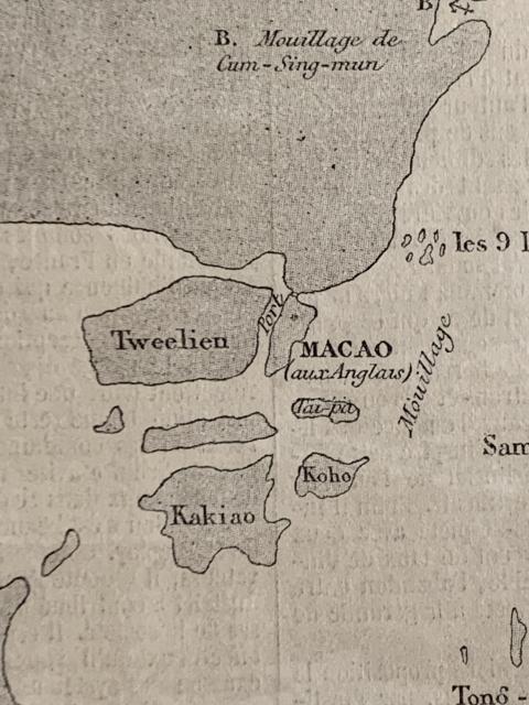
Thanks for sharing the maps. Any chance you could update this one with a crop showing slightly higher up the map, please?
The text on the map is just the key, then the location of the mouillage / mooring is shown by the "B" and the anchor that are chopped off at the top right of the current crop.
Based on Google Maps it is in present day Zhuhai. There is a bridge across the strait. A Wiki page in Chinese language stated British Opium smugglers used to anchor between the island and mainland.
i uploaded another image from the original 1858 map of the area around Cum-Sing-mun (https://gwulo.com/atom/38089). thanks for your tip re the wiki page!
I believe my search marker at Google Maps is correct. But after taking a second look. it would seem the traffic layer is not aligned properly with the satalite layer and is a bit off towards the east. On the other hand the present day putonghua pinyin confused matter a bit further.
TangJiaWanZhen (唐家灣鎮) appeared to be one of the present day township close to the physical location of Cum-Sing-Mun (Jinxiang Men). Comparing with the old map, I guess some reclamation had been done over the decades. No idea what is the boundary of the old village back in the time of the old map. If you look up 唐家灣 you should be able to come up with a load of photos of old houses so I guess the village exists for quite a while.
Comments
Thanks for sharing the maps.
Thanks for sharing the maps. Any chance you could update this one with a crop showing slightly higher up the map, please?
The text on the map is just the key, then the location of the mouillage / mooring is shown by the "B" and the anchor that are chopped off at the top right of the current crop.
Re: Jinxing Men (金星門)
Hi There,
Based on Google Maps it is in present day Zhuhai. There is a bridge across the strait. A Wiki page in Chinese language stated British Opium smugglers used to anchor between the island and mainland.
T
uploaded new image & updated link in my original post
no problem at all! just uploaded new image https://gwulo.com/atom/38089 and updated my original post
i agree with you! please see updated maps
hi tngan -
i uploaded another image from the original 1858 map of the area around Cum-Sing-mun (https://gwulo.com/atom/38089). thanks for your tip re the wiki page!
looking at google maps (https://gwulo.com/atom/38090), Cum-Sing-mun is present day TangJiaWanZhen?
Re: Jinxing Men
Hi There,
I believe my search marker at Google Maps is correct. But after taking a second look. it would seem the traffic layer is not aligned properly with the satalite layer and is a bit off towards the east. On the other hand the present day putonghua pinyin confused matter a bit further.
TangJiaWanZhen (唐家灣鎮) appeared to be one of the present day township close to the physical location of Cum-Sing-Mun (Jinxiang Men). Comparing with the old map, I guess some reclamation had been done over the decades. No idea what is the boundary of the old village back in the time of the old map. If you look up 唐家灣 you should be able to come up with a load of photos of old houses so I guess the village exists for quite a while.
T