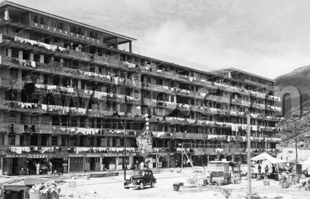
What: The 1956 Annual Report tells us more:
[...] the decision was taken in 1954 to embark on a gigantic programme for the construction of large Resettlement Estates of seven-storey blocks as the only practicable means of solving the squatter problem, and so releasing the land urgently needed for the houses, factories, schools, hospitals and other essential requirements of a rapidly expanding community.
The photo shows one of these seven-storey blocks. They were the latest in several government responses to the squatter problem. The 1956 report again:
Before 1954 the only form of resettlement offered to squatters was the allocation of sites in resettlement areas which consisted of terraced hillsides unsuitable for multi-storey buildings.
[In early 1954] temporary two-storey accommodation for 36,000 persons [was built as the initial response to the Shek Kip Mei fire].
By 1956 the hillside resettlement areas were still being developed "to the maximum extent possible", but the 7-storey blocks had become the government's preferred housing solution, as these figures from the 1955 & 1956 reports show:
| Population | 1 Jan 55 | 1 Jan 56 | 31 Dec 56 |
| One-storey buildings in Hillside Cottage Areas | 57,000 | 67,968 | 72,843 |
| 2-storey temporary buildings | 35,000 | 36,312 | 30,147 |
| 6- and 7-storey permanent buildings | 19,000 | 48,803 | 102,901 |
Who: The blocks were built to resettle residents of the squatter areas. Squatter huts can still be seen on the hillside in the background of the photo:

Which floor they'd live on depended on whether or not they'd run a shop in the squatter area. The 1955 Annual Report:
During the year it was also decided that settlers who had previously operated shops in squatter areas should be given the opportunity of renting ground-floor rooms for combined business and domestic purposes at a higher rental. Many have availed themselves of this opportunity. A rent of $100 a month is charged for a ground-floor room, 25 ft by 9 ft 6 ins (double the normal size).
Here's a typical ground-floor store, with barrels of rice out in front:

But most people would live on one of the upper floors:

The 1955 report again:
The blocks in the multi-storey estates vary in size and are in the shape of the letter H, the cross-bar of which accommodates lavatories, washing spaces and bathing cubicles, while the two wings [we're looking at a wing in the photo above] each contain anything from 56 to 128 rooms on each floor, each room measuring 12 ft 6 ins by 9ft 6 ins. The total number of rooms in an average block is between 500 and 600. The rent per room was provisionally fixed at $10 in 1954 [...].
Each room was 119 sq ft. By comparison, a typical double mattress (4'6" x 6'3") is 28 sq ft. You could lay four of those down on the floor have just enough room left to open the door.
Another figure mentioned in the 1955 reports is 35 sq ft, the legal minimum living space per adult at the time. So in theory the room could house three adults. When my wife was growing up, her family lived in one of these rooms. They were two parents and seven children!
Where: The 1956 report notes that:
The Education Department has also recently agreed that the penthouses on these roof-tops may be used for school purposes, and it is hoped that the present figure of three schools will soon be considerably increased.
From the writing on the side of the two 'penthouses', it looks as though these are already in use as schools.
Here's the writing on the closest one:

Does anyone recognise the location, or the name of the school?
When: The location and / or school should help give a date for this photo. Another possible clue is the car. Does anyone recognise the model, or even the licence plate (number 3866)?

I'll guess 1958 as the date - some time after 1956, when schools were started, but not too long after they began building these. Does anyone know when the last 7-storey block was finished?
Comments & corrections welcome!
Regards, David
References:
- All facts and figures come from the 'Housing' chapter of the Government's Annual reports for 1955 and 1956.
Reference: EC004
Comments
Resettlement Blocks
I posted a photo which is in 1950s HK - the car is a Vauxhall Wyvern.
Resettlement Blocks
Stephen, thanks for the photo of your family's Vauxhall Wyvern. Wikipedia says they were made between 1948 and 1951, so unfortunately knowing the car doesn't help us with the date of the photo.
I also had a couple of replies by email. Kelly wrote:
Looks like Wong Tai Sin to me,just a gut feeling tho.....
The car seems to be a Vauxhall Velox,chrome strips on the bonnet,late 40's to 1953/4 when a new model came out.
Wong Tai Sin is a possibility, I'm still hoping we get an id on the school to pin it down.
Wikipedia also has a page for the Vauxhall Velox. Turns out that was a sportier model, but based on the Vauxhall Wyvern body - I can't tell them apart, but in any case their manufacturing dates were the same. ("sportier" means you could do 0-60 in 22.8 seconds. Goodness knows how long the Wyvern took!)
Peter wrote:
I would hazard a guess that the car belonged to the photographer. Do we know who he/she was?
Yes, that would make sense. But sorry, I bought the photo on its own, so I didn't get any info about who took it.
Thanks for your feedback. Any more ideas on the location ?
Regards, David
Re: Chinese characters - Name of the school
Hi there,
That was the name of the school alright. It looked like 基督教傳道會X恩學校分校 to me. Could not recognize the X. Is there a higher resolution copy of the photo please? Don't know if it is a secondary school or a primary school just by its name though. We might be able to pin point the block if the name of th school could be recognized.
Thanks & Best Regards,
T
Name of Chinese school
Hi T, just thinking aloud from looking at the picture. Can it be 聖恩?
Re: Name of Chinese school
Hi there,
It could be﹐ but I was unable to match them up in the list of defuncted primary school or secondary school at Wiki. We would need someone knowledgeable in post-war education for this, or have to lookup Government archives for resettlement blocks.......
The name of the school should also be seen on the other side of the building. I think this school was one of those roof top schools. However this one at least has a few classrooms with its own roof.
Best Regards,
T
Re: Name of Chinese school
Hi T, You can zoom in a bit more on this photo. Is it good enough to read?
Regards, David
Re: Name of the Chinese school
Hi there,
Unfortunately not. All the brush strokes are muddled up. It could be a '聖‘ or an '愛’﹐ however both of them could not be matched against the school lists at Wiki. The Government might have another list, but I am uncertain since when did private schools had to be registered with the Education Department. If that school was earlier than the ordinance then we might not be able to verify.
Best Regards,
T
Mysterious word
Looking at the enlarge photo David posted, the shape looks like a possibility for 重 as well. However, 重恩 doesn't sound very 'Christian' as a school name.
Is it possible that in those early days (1957 or 58) of roof top schools, they didn't have to be registered, or their existence were simply too brief to warrant a mention? My mom studied in one of these places (it was without a roof on the roof top) and she tells me they turned over quite quickly.
Re: Mysterious Word
Hi there,
I was unable to find any reference to '基督教傳道會' as well. What I got was ‘中華基督教傳道會' from my google searches. I'm really uncertain if the two would add up.
Best Regards,
T
Re: Mysterious Word
Hi T - Re the church that the school in the photo was affiliated with:
1. Denomination - The closest present day match that I managed to find (on Wikipedia) is 中華傳道會 (CNEC). However I agree that this may not be the same thing as 基督教傳道會.
2. Church - I think the name of the church is 靈恩堂. There are actually 2 present day churches of that name, but they don't even belong to CNEC! So unfortunately, it seems unlikely for either to be the church that we're looking for.
Hope others can chime in with fresh information.
Re: Mysterious Word
Thanks for the extra detective work going on here. If we can't find something now, hopefully in future we'll catch someone searching for those names in Google, who can tell us the answer.
Regards, David
Re: Chinese characters - Name of the school
T, shall be read as "香港傳道會靈恩學校"
Regards, JW
Any more thoughts about the school?
I'll include this photo in the new book 4, and would love to mark its position on the map at the back of the book. If anyone has any new information about the school's name and location, please let me know.
Regards, David
Difficult to ID the School
Looks like construction work has begun in front of the estate. Perhaps for a playground, concrete pitch etc. Noted the estate is close to the hillside. A photo of Kwun Tong Resettlement Estate.
re: Difficult to ID the School
Yes, I guess this one may have to remain a mystery, though that photo of the Kwun Tong Resettlement Estate is a good find and certainly a good candidate.
The sign for the shop is clearer to read, but I doubt there will be many records of it - maybe we'll get lucky and hear from someone who'd lived there and remembers it.
resettlement block
One of the ways to narrow down the location is to examine the aerial images for that time. You can see that some of the H-blocks were much shorter and therefore had shorter roof canopies on either side (for example SHek Kip Mei). Kwun Tong fits quite well here, but my understanding is it wasn't built until the 1960s. Lei Cheung Uk had similar size blocks but the roof canopies weren't as long, same with Tai Hang Tung etc. Is it possible the image was taken in the 60s and the car is a bit of a red herring?
Some examples here: Lei Cheng Uk - https://www.hkmapservice.gov.hk/OneStopSystem/map-search/getPreviewFile…
Tai Hang Tung - https://www.hkmapservice.gov.hk/OneStopSystem/map-search/getPreviewFile…
Kwun Tong - https://www.hkmapservice.gov.hk/OneStopSystem/map-search/getPreviewFile…
Wong Tai Sin/WAng Tau Hom - https://www.hkmapservice.gov.hk/OneStopSystem/map-search/getPreviewFile…
Re: Resettlement block
Hi There,
If the car is concerned, I remember cars of similar built\shape still exist in town in the late 1960s despite those would be sort of old. I recognize just teh shape, not the brand and model. I remember most European cars (even the Mercs) are sort of having more curves while Japanese cars (that become abundant in the 1970s) seemed to be more angular.
T
I've had a look at the
I've had a look at the original photo again, but there isn't any information about the date on it. The style isn't like the typical tourist photos from the 1950s though, so it could well be from the 1960s.
李鄭屋徙置區 (Lei Cheng Uk Estate)
I think the school name is "基督教傳道會靈恩學校分校"
基督教 = Christian/Christianity
傳道會 = Missionary
靈恩 = Charismatic; so "Charismatic Christianity" (https://en.wikipedia.org/wiki/Charismatic_Christianity)
學校= School
分校 = Branch school
This appears to be the first installment of the Lei Cheng Uk Estate (now demolished), which was 7-storeys high, erected in the 1950s after the Shek Kip Mei fire (1953) to resettle the residents in the Shek Kip Mei shanty town/squatters area.
This Facebook group page has a similar photo: https://www.facebook.com/groups/mankooyeung
Maybe worth posting your photo here to the resident group and they might be able to verify? But posting in Chinese may get you more answers, as the FB page members seem to communicate in Cantonese.
Their Facebook page also has tons of old photos you might like!
This Wiki page talks about what I think is this school on the rooftop, abbreviated as "靈恩學校", on the rooftop of Block 3, but you can only see this in the Chinese version of Wiki under the section "教育" (Education), not the English version:
https://zh.m.wikipedia.org/zh-hant/%E6%9D%8E%E9%84%AD%E5%B1%8B%E9%82%A8
In terms of narrowing down the date of the photo, this here may help:
http://philenid.tripod.com/Pastor/MDiv/HKEC_history.htm
"1956年 8 月, 在李鄭屋新區 L 座天台開辦第二間兒童會,後註冊成為『靈恩學校』.後在1970年成立教會,稱為『恩佑堂』。在1979 年, 因政府加租幅度龐大,靈恩學校停辦。"
It says here that, in 1956 August, the Lei Cheng Uk Estates Block L (this is the old name for Block 3) opened the second "children's association", later regisrered as "靈恩學校". If this is indeed the school we are talking about in this picture, then in 1979, due to government increase in rent, the school "靈恩學校" terminated its operation.
So, this photo may have been taken between 1956-1979.
It may be helpful to know that the blocks in the first installment of Lei Cheng Uk Estates were alphabetized, and later changed to numbers, but not in a straight forward fashion like A=1, B=2, C=3, etc. There is a look-up table in the Wiki page above (only in the Chinese version):
According to this table, Block L (later renamed Block 3) was built in 1955, and demolished in 1984.
Best wishes
Vanessa
Lei Cheng Uk?
There's really only one block that looks to fit the size and rooftop style seen in the main image and the background/orientation of it just doesn't fit the area around Lei Cheng Uk. It's the block that sat on what is now Lei Cheng Uk playground to the north of Wai Wai Road and was built with the long side on a NW/SE line. Marked below.
If it is this block, then the only orientation that makes sense would be viewing this block from the SW in the main image with the background hill containing Tai Po Road. (Viewing it from the north would mean the large slope in the main image is in the middle of the estate!). However, my understanding is that the two blocks immediately south of this one (to the left of the arrow) were built first, which means it would never have had the open space that we see on the main image. Additionally, the background slope just doesn't fit the hill that is there. It's too far away, shows no sign of Tai Po Road and is not steep enough.
Kwun Tong?
Could this be the same building (in Kwun Tong) a few years later on HK Memory ?
https://www.hkmemory.hk/MHK/collections/hkplaces/AllItems/images/201107…
1950s 7-storey resettlement block location
Greetings! The fuzzy character is top heavy and wider than the bottom, with its waist line in between. It does not look like 聖 or 靈 which are on the square side. I think tngan's 愛 remains a strong candidate as the school list at Wiki may not be completely accurate.
Thanks to all for your interesting research. Using philk's explanation, I take it that the camera would be looking to the east-northeast. The photo seems to show two hills both sloping downward towards north; but I could not match them on the 1952 map. Regards, Peter
Hmmm, however, the characters
Hmmm, however, the characters were written in Chinese calligraphy style (rather than in printed form), so the form of the character can be top-heavy as below:
There are other styles:
https://www.70thvictory.com.tw/shufa/ling7779_xs.htm
"愛恩" doesn't sound right in either Cantonese or Mandarin, and never seen this combo for Christianity/religious affiliations. "靈恩學校" remains a good possibility, because it carries a sensible meaning and it is actually one of the rooftop schools listed in the HK resettlement blocks, although, without seeing this character clearly, we can't be 100% sure. "bunce" and "JW" in the thread above had also suggested the same.
Probably the best bet still is to post the picture to the Lei Cheng Uk residents group at Facebook and ask them - they seem to share memories of those times in that group, and they talk about what life was like in those days. I think someone there can give a definitive answer - either yes or no, and maybe even able to help locate it.
BW
Vanessa
Calligraphy vs Digitized on screen
Thank you Vanessa for your explanation. I never thought a difference between a calligraphy and its digitized format is so critical here. The fuzzy word has a slight longer first stroke at the top compared to your choice so it could have been the actual calligraphy or altered in the scanning, printing or enlarging process. Agreed - 愛恩 is a bit strange for a school name and I am not sure of its meaning. Regards, Peter
7-storey block
Thanks for the extra input on this.
Looking at the Kwun Tong photo from Moddsey and Ed, the rooftop shelter appears to just be a roof with nothing built under it. But both the rooftop shelters in the main photo have windows and name signs, as though they've been enclosed as schools. The shelters may have changed use over the years, so it isn't conclusive, but it suggests the two photos are of different buildings.
I've just written to the admin of the Lei Cheng Uk FB group to check it's ok to post these photos there.
Regards, David
7-storey block - not Lei Cheng Uk
The helpful members of the Lei Cheng Uk group on Facebook have taken a look at the photo and don't think it was taken there: https://www.facebook.com/groups/mankooyeung/permalink/3697131370320875/…
Based on Samu Chan's translation of the school name, he thinks the school may have been on block 17 of the Chai Wan resettlement estate.
impressive
an impressive bit of detective work. So that would mean the hill in the background is the back end of Mt Parker?
Chai Wan Estate
Fascinating!
Now, Samu Yau translated the school name as we had done above - it is indeed "基督教傳道會靈恩學校分校", so the mysterious character is now resolved. At least we know the name of the school in the picture.
This may be useful - it's a historic short film / documentary on Chai Wan Estate Rooftop Schools in the 1960s - it is in English
https://m.facebook.com/watch/?v=713980709045949&_rdr
At timestamp 2:05-2:07, it clearly shows that the name of Block 17's rooftop school is:
"香港小童群益會柴灣17座兒童會"
香港 = Hong Kong
小童群益會 = The Boys' and Girls' Clubs Association (of Hong Kong) or BGCA
柴灣 = Chai Wan
17座= Block 17
兒童會 = Children's Association
So this is an entirely different name - did the school change names as well as adminsitrators? It is possible, because in this Wiki page, it lists that the rooftop school for the Chai Wan Estate Block 17 rooftop has this name "靈恩堂小學暨幼稚園" (https://zh.wikipedia.org/wiki/%E6%9F%B4%E7%81%A3%E9%82%A8#%E6%95%99%E8%82%B2%E8%A8%AD%E6%96%BD)
靈恩堂 = "Ling Yan Tong" = "Charistmatic Christianity" church
小學 = primary school
暨 = "and" or "&"
幼稚園= kindergarten
Maybe worth forwarding to Samu for clarification and see what he thinks?
BW
Vanessa
David, when/if you reply to
David, when/if you reply to the thread at the Lei Cheng Uk Estate Facebook page, this below maybe helpful for residents who don't read English and maybe someone from Block L (block 3) can either say yes or no as to whether this school was on top ot it. This is written in Chinese-Cantonese:
"Kind request to verify whether the rooftop school in the photo was the [name] in the historic Block L (Block 3) in Lei Cheng Uk Estate"
請問圖中嘅天台學校, 會唔會係李鄭屋邨以前嘅L座 (第三座) 嘅 "靈恩學校"?
May increase yield of replies if your original post can be re-posted also in Cantonese in hopes that one of the previous Block L (Block 3) residents can say yes or no.
Another possible source of verification could be to contact the Christianity group itself - need to see whether this was the same Christianty group but the name is definitely very similar. This page talks about their history, stating that the original name of the church when established in 1951 was「香港基督教靈恩堂」(rough translation: Hong Kong Charistimatic Christianity Church). In 1958, they formalised their name to 「香港基督教傳道會靈恩堂」and that they had established schools in the 1960s with the name "靈恩" (Charismatic Christianity). Note that this name is very very close to the school you posted in question "基督教傳道會靈恩學校分校".
They are now called "Pentecostal Holiness Church Ling Yan Assembly Limited"
靈恩 (the key word here "Charistimatic Christianty") is pronounced "Ling Yan" in Cantonese and it is in the current English name
https://www.phclya.org/index.php/about-us/
Chai Wan
It also says in the 1958 section of Vanessa's link : 於柴灣炮台山地段興建新堂,易名為「香港基督教傳道會靈恩堂」
I'm assuming the fortress being referred to is the one that was turned into the coastal defence museum or perhaps the battery on Sai Wan Shan and that the church was nearby? It makes sense they would have a school close by to the church.
Residents of Block L (Block 3) of Lei Cheng Uk
Browsing through their conversations with each other on their FB page, these previous residents have self-identified that they studied at the rooftop school "靈恩學校" of Block L (Block 3):
https://www.facebook.com/groups/772049429495765/user/100000253672862/
https://www.facebook.com/groups/772049429495765/user/100001198863347/
Reidents of Block 3 (Block L):
https://www.facebook.com/groups/772049429495765/user/100001636181091/
https://www.facebook.com/groups/772049429495765/user/100005388011424/
https://www.facebook.com/groups/772049429495765/user/1751876626/
Even if we get a definitive "no", it would be quite helpful to rule it out. The name of the school in David's picture does say "branch school" so maybe it was not the original, and still possible that the branch school was later established in the Chai Wan Estate (or another resettlement block).
These FB users state that they lived in Block 17 at the Chai Wan Estate - might be able to help
https://www.facebook.com/agogoduck?comment_id=Y29tbWVudDoyMTAxMDc1MjI2NTg1MDgwXzI2MTMzNjQ0NjUzNTYxNTE%3D
https://www.facebook.com/kaikeung.mok?comment_id=Y29tbWVudDoyMTAxMDc1MjI2NTg1MDgwXzIxMDExOTM5NDMyMzk4NzU%3D
https://www.facebook.com/kphau?comment_id=Y29tbWVudDoyMTAxMDc1MjI2NTg1MDgwXzUwMzU2MzE2NjMxMjk0MDc%3D
https://www.facebook.com/anthony.chan.1804?comment_id=Y29tbWVudDoyMTAxMDc1MjI2NTg1MDgwXzI2MzYzMzkwMTk3MjUzNjI%3D
https://www.facebook.com/feihung.ngai?comment_id=Y29tbWVudDoyMTAxMDc1MjI2NTg1MDgwXzIxMDI5Mjg1MTk3MzMwODQ%3D
These maps of Lei Cheng Uk Estates may be helpful - it could be that the orientation of the blocks would suggest that it doesn't match the photo. Also, Block 3 (Block L) is shorter (as mentioend previously in this discussion). These are from the Lei Cheng Uk Estate Facebook page:
If this school were in Lei Cheng Uk Block L (Block 3), does it mean that this picture must have been taken before Block M (Block 4) was built to get that open piece of land in front of it lenghtwise? This is assuming they built it sequentially and in alphabetical order. But then maybe the background hills and skyline don't match? Also, it seemed like they finished building an installment of blocks before letting people move in, not building by building.
BW
Vanessa
Resettlement block
Hi Vanessa,
Thanks for investigating this some more. The folks at the Lei Cheng Uk FB page don't recognise the building so I've switched attention to Chai Wan for now.
One other clue from the original photo is the car and street lamps, showing there was a road in front of the block. It suggests the block was at the edge of the estate. Photos of Block 17 at Chai Wan also show a road in front of it at a similar location.
I've just posted the photos to a FB page for Chai Wan, and will add a comment here if they have any extra information to add.
Regards, David
Resettlement Building - Location Search
Greetings. Using the 1970.1 map, I am exploring the possibility that the photo was taken from Chai Wan looking to the east northeast matching the ridgeline the only criterion. A counter-point is that the smaller building just east of it is not in the photo, while the open field to the south agrees with the photo and the laneway enabled the car to park there . If correct, this building would correspond to today's Wan Tsui Estate. Regards, Peter
Here's an aerial view of Chai
Here's an aerial view of Chai Wan in 1961, with the blue arrow showing a possible line of sight to match the original photo.
The document Heritage Impact Assessment on Chai Wan Factory Estate at No. 2 Kut Shing Street, Chai Wan, Hong Kong includes some good information about the Chai Wan Resettlement Estate:
Chai Wan Resettlement Estate, Block 17
If one googles Chaiwan (sic) Resettlement Estate, a few images of Block 17 can be viewed. See here
Chai wan
The roof canopies on the right hand side do not match, but the one's on the left (9 o'clock) seem to fit better.
Chai Wan
I think David and Klaus have found the matching building.... it would place the building at the sourth-eastern tip of the current Chai Wan Road across the street from the Bus Station on the 1970.1 map. The same map shows two buldings just east of it and they appear to match those in Klaus' photo. The camera in the main photo would be looking to the southwest and that could be the southern slope of Mount Parker.
The traffic pattern has changed considerably but I think the road in the foreground is the current Wan Tsui Road.
Is it optical illusion? One roof top is longer than the other in Klaus photo.
Regards, Peter
one more Chai Wan
This photo of a sign in Chai Wan (from Wikimedia Commons) probably shows the wanted house.
And one more on HKMemory showing Mark I buildings no. 20 and possibly no. 17.
1970 Chai Wan Resettlement Estate, Block 17
Block 17 is shown below. The only signs are the lamp post and hill on the right.
School name
On the side the 4 Chinese words looks somewhat like 靈思分校. The 11 or so white dots visible on the front corresponds to the school name in the original photo.