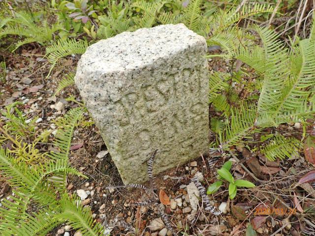
A hiking pal came across this boundary stone at Sze Tau Leng 獅頭嶺,Fanling the other day. In the 1952 map, this place was called Kwai Tau Leng, the namesake for the peak nearby as is called today.
Looks like it has the words " Forestry Lot no. 125" inscribed on it. The first letter of the first word is missing, so it's just a wild guess.
It's not near the reservoir nor catchwater.
Is there any other bs of this type in HK and what is the purpose of forestry in this area at that time?
Date picture taken
21 Mar 2020
Gallery
Comments
Forestry Lots
Skimming the results of this Google search, it looks as though they were plots of land that had traditionally belonged to a village, and were formalised as "Forestry Lots".
Forestry Lot
Thanks for the links.
re: Forestry Lot
This might be of help re forestry lots. But I do not have any idea of those stone markers.
Before, the New Territories Adminstration gave out temporary Forestry Lot permit to the village chief to allow the villagers to gather branches, shrubs from the hillside around their village. The area is designated for that particular village and on the permit it marks out on a map. Every year they have to pay Crown rent for this permit.
When Govt. wants to take back this area they will count out the large, medium, small pine trees and pay back the villagers compensation for loss of use.
Re: Forestry Lot Stone
As noted here in para. 3: After Forestry Licences have been issued, the Licensees shall mark out the land in respect of which they are granted licences clearly at each corner with a board or stone bearing the licence number and shall maintain such marks during the term of their licences.
It seems strange that the
This boundary stone is only in English and was come across by a hiking group couple of years ago at the northern slope of Tai Leng Pei, i.e. a hill of 170m east of the barrack.
The stone is located SE of Ko Po Shan vs SW of Sze Tei Shan.
I tried to search for it the other day without success, the vegetation was too dense with fern, and the coordination we have at hand may not be that exact. Will try our luck again in the coming weeks.
Perhaps they visited it after a hill fire. The guy in the farm at the hill foot also believed that there's such a stone.
The area we searched was a spur with a long flat ridge down below, SW of Duke's Hill.
We descended from the viewpoint of Hok Tau Country Trail, passed a pylon, turned right ...
It seems strange that the farmers only marked the borders of the lot in English, when most people in the area were illiterate ... Most of the farmers didn't study English in those years, right?