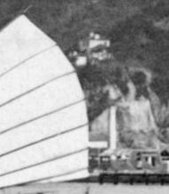
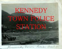
Current condition
Demolished / No longer exists
Date completed
Date closed / demolished
(Day & Month are approximate.)
Moddsey found this description of the Police Station:
1900 PWD Annual Report
A new Police Station was built on a site selected above the Cattle Depot on the road leading to Pokfulam and completed on 1 October 1900.
The previous Police Station in Kennedy Town (see http://gwulo.com/node/17695) had been converted for use as a hospital.
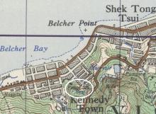
The marker location is a guess. I haven't seen it marked on any maps yet - if you know where it was, please let us know. [UPDATED: Marker moved to correct position based on comments below.]


Comments
Kennedy Town Police
該位置已在地圖GSGS3868上標記。您可以在互聯網上搜索。
Re: Kennedy Town Police Station
Jade Ling posted a 1930's map where the location is shown. The marker should be more to the east at the bend of todays Pokfield Road.
Thanks Jade and Klaus, I've
Thanks Jade and Klaus, I've moved the marker to the correct location.
Looking at the maps at http://www.hkmaps.hk/mapviewer.html, I see that "Map 1922" is a good one for locating Police Stations.
position of the police station
Hi,
According to "GEO REPORT No. 152" prepared by the CEDD department of HK (Link: https://www.cedd.gov.hk/filemanager/eng/content_307/er152_links.pdf , a slope incident report), the "figure 3 site history" mentions that off the slope of Pokfield Road near the University Heights there were buildings and platform appeared from 1901 to 1969.
This piece of information match the background information related to the "second generation police station" mentioned in this discussion dialogue.
By the way, the figure 5 of the report shows the end of Rock Hill Street in the past.
I hope it is a useful material.
(My name is Chai. I like studying hong kong old photos very much. l like researching into the Sai Wan District very recently.)
Regards, Chai
Thanks Chai, I've set the
Thanks Chai, I've set the demolition date to 1969.
Use of the building after WWII
I think the building of the original police station existed until 1969, accroding to Chai's comment and CEDD report. However, I guess if the use of the building was changed after WWII.
We can see a map in 1950 in fig.1. The location of the police station was marked as military officer's quarter (軍官宿舍) . Another map in the 1960's shows that the building was for the use of USD staff quarter (fig. 2).
Fig. 2 also shows the end of Rock Hill Street in the past.
Hope my findings useful to all of you.