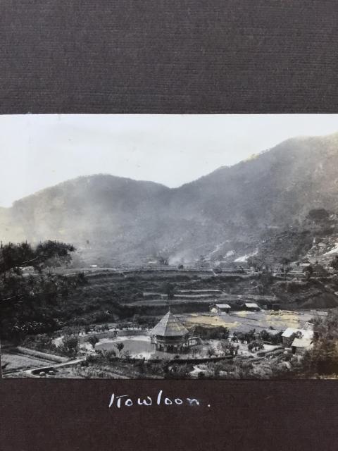
This photo shows the skyline of the previous photo and may help to locate it. Both photos are from the 1928-1929 album of William Richmond Fell while he was commanding HM Submarine L3 on the China Station.
Date picture taken
1928
Gallery
Comments
Piper's Hill?
Hi Jill
It's just a guess but this looks like Pipers Hill in the NW/Cheung Sha Wan area of Kowloon. I think the road running up the hill is Tai Po Road which would put the pavilion somewhere in the vicinity of today's Lei Cheng Uk estate or perhaps So Uk estate. I think back then the areas were known as So Uk and Wong Uk villages.
Regards
Phil
Mysterious pavilion
Many thanks for trying to place this mysterious pavilion, philk. I suppose the area is now completely built up. Lt-Cdr Fell obviously thought it worth recording as a local curiosity. It's quite a small reservoir to warrant a pavilion and I wonder who built it and why, originally.
Best wishes
Jill
Cheung Sha Wan 1928
Hi Phil, Impressive! Not a surprise you know this place. One aerial view looking north, from just south of Cheung Sha Wan Playground on Google maps, shows the same ridgeline. This looks like a duck farm no wonder there is a street called Apliu Street. Regards, Peter
Cheung Sha Wan
Hi Peter
yes, I walk past this area almost everyday. I'm just having difficulty zeroing in on the location of the pond because I can't quite figure out the distance from the hills. I think the general area is correct though. I was trying to figure out why a pond and pavilion would be at this location but if you say it's a duck farm then that makes more sense to me than it being something less functional (I was thinking some kind of local beauty spot). Did duck farms have these over-water constructions then?
Phil
Cheung Sha Wan 1920s
Thank you Phil for the comments. From looking at the aerial photo's ridgeline, I estimate this pond was somewhere on the north-south line running through the current Cheung Wah - Po On junction. The 1952 map shows the land there starting to rise, and the 1956 map shows several villages to the north which I assume already existed in the 1920s.
Several tributaries flowed through the area so a duck farm was feasible, and the high wall on the perimeter keeps the flock in. Some photos in the New Territories show pavilions on wet farmlands. This one looks more elaborate so it could be a hobby farm, a beauty/tourist spot. Those fuzzy spots look like ducks -wish I could hear them quack and see them walk. Regards, Peter
Re: Photo
Tend to agree with Phil and the location. Given the year, the photo was probably taken in the vicintiy of Sham Shui Po Camp. An aerial view of the Camp and the farmlands to the north and northwest can be viewed here
A ground view of 1927 Sham Shui Po showing farmland and a circular duckpond on the left.
Duck Pond 1920s
Thanks moddsey, very helpful and intereting photos. Your photo (1927 1. Shum Shui Po) showing the pond on the left could be the same one in the top photo on this page. The top photo has the pavilion on the north side of the pond judging by the hills in the background, which would then be out of picture on yours. In my time living in HK, it did spell Shum as in the photo. Regards, Peter
Another Explanation of the Photo Location
Had a re-think. Another explanation for WRF at the photo location could be the presence of the torpedo range at Lai Chi Kok. The range was still in use in 1929. This may sound more plausible.
Torpedo range at Lai Chi Kok
That is very clever detective work, moddsey. Your deduction is endorsed by WRF's grandson. I wonder if the other farm landscape that I uploaded, just labelled "Hong Kong" and that I titled "Agriculture" was anywhere near, although WRF would have probably labelled it "Kowloon" if it had been.
Hills Behind Sham Shui Po Barracks
Similar Photos from Northampton Museums
Re-visited the original photo. As mentioned previously, the scene is at a distance from Sham Shui Po Camp and closer to the foothills. Found photos of the Chinese market gardens and circular duckpond here and here from 1927-1928.