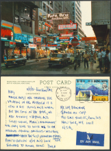
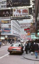
Named after: It was originally named after Sir Paul Chater, but now it is named after the capital city of China.
Timeline:
- c.1890: Street first laid out. Item 31 in the PWD's report for 1890 says:
- A new road called Chater Road is being formed by heavy cutting at the back of the Tsimshatsui Police Station. This will materially shorten the approach to the steam ferry from the eastern side of Kowloon.
- 1909: Street renamed to Peking Road
- See item 184 in the Government Gazette. It lists several streets with names that were also used elsewhere around Hong Kong, and that were renamed to avoid confusion. (At the time there were also a Chater Road and a Chater Street on Hong Kong island.)
The Gazette gives the original name of this road as "Chater Street", though maps from the time show it as "Chater Road".
- See item 184 in the Government Gazette. It lists several streets with names that were also used elsewhere around Hong Kong, and that were renamed to avoid confusion. (At the time there were also a Chater Road and a Chater Street on Hong Kong island.)
Other points of interest:
Current condition
In use
Date street completed
(Day, Month, & Year are approximate.)
Photos of this street:
(see more)


Comments
More to the west
On the 1896 map, (the then) Chater Road extended to the praya (named West Bund on the 1892 map on hkmaps.hk). The part of the road west of Canton Road disappeared when Ocean Centre opened in 1977.
re: More to the west
The 1896 map does show a road running between buildings on the Kowloon Wharves land, that roughly aligns with the line of Chater Road.
I'm not sure if it was considered part of the public Chater Road though. Earlier maps (eg Map 1888 at http://www.hkmaps.hk/mapviewer.html) show it existed before Chater Road, so I guess it was a private lane on the Kowloon Wharves land.
re: west
You're probably right, my original proposal was based on the 1892 map where the name's print starts left of Macdonell Road.