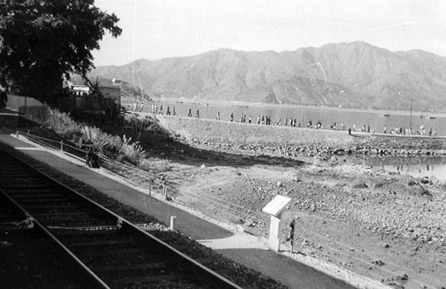
One day several of us took the train up to Tai Po Market. The end of the platform at Sha Tin station, (actually Tai Po Kau) is visible on the extreme left of this photograph. Please see the later corrections as to the exact location.
Date picture taken
1958
Gallery
Shows place(s)
Comments
Not Shatin
This will have been the original Taipo Station in Tai Po Kau. It was later renamed to Tai Po Kau Station (not sure when, someone has told me circa 1967) because I think the name caused confusion with Tai Po Mkt Station(?). The pier (which is still there) was a major dropping off point for boats coming and going from all around the Tolo Harbour and Tolo Channel areas. The station was decommissioned and subsequently demolished in 1983 following electrification of the line.
Thank you, Phil for the more
Thank you, Phil for the more accurate identification. Now, I can see that the Island, with the distinctive Island House is visible at the extreme left of the photograph. Google Earth shows it all very well. Which station name should be used in the title? Best wishes, Andrew
Tai Po Kau
Hi Andrew, well spotted! I hadn't even noticed Island House and only recognised the ridge line in the distance. I think Tai Po Kau is probably a better description as it identifies the specific area of Tai Po that we are looking at.
Phil
Thanks Phil. I much
Thanks Phil. I much appreciate everyone's help in better locating the places on all these photograhps. I'll change the title. Best wishes, Andrew
TAI PO KAU RAILWAY STATION
During my school days we lived in Taipo Kau and would see this scene almost every day as the train was our normal way to and from Kowloon.
This photo pre-dates the building of the Marine Police base, which would be on the mid right of the picture if you were able to stand in the same spot today.
There is/was a small promontory further up the track, behind the photographer. Pre-war it was a KCR staff swimming club. By the time we arrived in TaiPo Kau in 1952 the buildings were ruined and overgrown, and truth be told the beach on the eastern side was rocky and the western side was thick mud. A one-man boat builder had established himself there and seemed to build about one sampan per year. These were launched with great ceremony - firecrackers; a leafy branch tied to the bows; roast pig; monk’s blessing
By stages people started keeping pleasure boats there, for which he charged a fee for “looking after boat”.
Initially the boats were smallish and pulled up on the muddy beach at the boat yard, but later on some moorings were laid and the boats swung at anchor.
Whenever a typhoon hits HK it is usual for the wind, tide and lower air pressure to cause the sea level in Tolo Harbour to increase dramatically - in typhoon Wanda (See: https://www.hko.gov.hk/en/informtc/no10/wanda/wanda.htm) it came up about 20 feet in places where the waves were caught by the shape of the shore - about three miles back towards Kowloon from this location the waves rose over the railway embankment and shifted the steel rail track about ten feet inland, and washed an ocean going freighter above the high water mark from where it could not be recovered and had to broken up.
From our house we had a clear view of the beach in the photo and so long as the phones kept working - which was the exception in a typhoon - we could keep up a running commentary to the boat owners as their pride and joy broke their moorings and fetched up on the beach.
Others events also took place on the beach in the photo, but we’ll keep those reminisces for another day.
Tai Po Kau
Thank you for contributing your very interesting memories about the Tai Po Kau area. In 1957/8 we would have been on our way up to Tai Po Market, and we would not have alighted from the train at this station. Our only destinations would have been either Tai Po Market or Sha Tin, so your recollections of growing up in the Tai Po Kau area are fascinating and make a valuable contribution to Gwulo. I'm, sure that other readers will look forward to hearing more of them!
I have just been looking at Google Earth and its street view of the area and, as is the case for most of Hong Kong, things have changed so much since the mid 1950s. However, the pier visible on Google Earth would seem to be in the same place as the rocky 'jetty' on which the people are walking on Bruce's photograph. Google Earth also shows that about 200 metres to the East of that pier there is a short wooded headland that would probably be the one where the sampan builder had his premises? It seems to fit the bill. I see that the shore at its Eastern side is very rocky, and it looks as though the shoreline on the side closest to the pier had once been muddy.
I had a long read of your link to Typhoon Wanda's destructuve wild career through Hong Kong. I was fortunate in my short time there that we didn't have any typhoons, although you will see in my photographs and comments that the aftermath of typhoons Wendy and Gloria in 1957 were still apparent when I arrived that October.
Best wishes, Andrew
TAI PO KAU RAILWAY STATION
Yes, indeed that is the spot. The old boat builder, the Taipo Boat Club clubhouse, boatshed, and the hardstanding for the boats has all disappeared under the highway. Also a very stoutly built stone hut. It had a thick steel door. Since that land used to belong to the railway, I would speculate it was once used to store explosives for use on the railway. A microcosm of the stone buildings on Kellet Island that were used by the navy to store gunpowder, in the days when Kellet Island was a long way from habitation, later moved to Green Island.
What is left of the little peninsula is now part of the “Tolo Harbour Park” and has some BBQ facilities.
You can get there by joining the seafront cycle path at Island House. You could get there by going down to the railway staff quarters (Trackside Villas - there must be a romantic lurking in the depths of the railway system ) but looking at google that seems to have been turned into a fortress like encampment.
Some years back a sailing friend and I went down to have a look at what for many years was our “home” on Sundays, and did actually spot some debris from the old buildings strewn on the foreshore, but otherwise no trace.
Looking at Google it seems history does repeat itself, as it shows the “MTR Staff Club house” on the land once occupied by TaiPoKau station - I wonder if the people who use it know how close they are to the 1920’s KCR swimming club ? Do they just swim in the pool or take the underpass to the seashore and brave the waters of Tolo Harbour ?
There used to be a very small railway siding roughly under where Trackside Villas meets the MTR Clubhouse, it ended in a corrugated iron shed, and unless my memory fails me (a fairly usual occurrence ) it housed one of those railway handcars as seen in so many old movies and cartoons. I only ever once saw the siding used, it would barely take a single carriage, so I think its only purpose was to house the handcar, enabling the stationmaster to rush at lightning speed to any incidents on the track.
Thank you. All our memories
Thank you. All our memories add to the increasingly hidden history of the old Hong Kong. Using Google Earth and its amazing 3D ability along with the Street View, it is great to see the places you remember so well from your childhood. In my copy of the excellent Land Department book, 'Hong Kong in Old Times (aerial photos taken in 1964)' I have used a magnifying glass to see whether there is any sign of the railway siding that you mention. The resolution is not too good but the shape and location of the level site for the new MTR Club House exactly matches that on the 1964 aerial photograph which with a bit of imagination might show a very short railway siding. If you can get hold of a copy of that book (ISBN 962-567-185-4) you will find that its images are very nostalgic.