From Wikipedia (public domain)
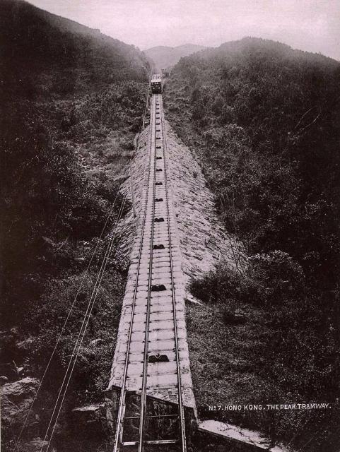
It looks as if in the early years of existence there was no bridge across the tram line. The map from 1905 doesn't show a through road for MacDonnell and (then) Bowen Roads. In the map from 1909, they seem to be in use, also May Road.In the lower part of the photo, the tram bridge over Kennedy Road is visible.
Text deleted after David's comment.
Date picture taken
1888
Gallery
Shows place(s)
Comments
The gap in the foreground
Hi Klaus, The section of the tracks with the bridge over Kennedy Road is flatter, but the section in this photo is still steep. I think the gap visible under the tracks here is more likely to be a drain to let rainwater flow under the tracks.
Something else about this view - the camera is not positioned at track level. Somehow it is raised high above the tracks to get this view. The photographer has probably set up the camera on the Magazine Gap Road bridge where it crosses the tram tracks.
If you zoom into the foreground of this photo https://gwulo.com/atom/19399/zoom you can see the bridge, and a very similar drain under the tracks that is likely the same one shown here.
Regards, David
Peak Tram
Hi David,
yes, you are right. This photo is similar to this from 1899 and also shows a steeper part on the track. Most likely, the Macdonnell and Bowen Road (now Magazine Gap Road) bridges were already built during Peak Tram construction. Only the May Road bridge is from 1907. I will prepare a compilation of bridges to end (my) confusion.
Reagards, Klaus
Peak Tram at Magazine Gap
Hi Klaus,
that's at Magazine Gap, the gap under the tram tracks is for the nullah that runs between the Galddon and Grenville House, The gap is also visible in the other picture you posted of the Peak Tram approaching the Bowen Road Bridge.
The nullah is visible just to the east of the Gladdon on May Road, but seems to be covered as it runs down the hill.
The steep embankment was…
The steep embankment was between Bowen and May Roads and is now overgrown, so not as obvious. In the 1950's there were narrow concrete steps on the right side of the tracks. One day my nine-year-old self decided to try walking up the steps, but misjudged the time needed to reach May Rd before the next tram descended. I scuttled off down the embankment to Brewin Path, but the tram slammed on the emergency brake, halting operations for some time.