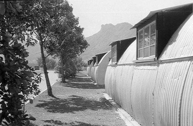
Greetings, and thank you Andrew for the photo of the Nissen huts, taken while I was still attending Good Hope School. They are the same as the ones shown along one of the two service roads on the left of this aerial photo. Given its foliage and alignment further up, the service road closer to the main road is my conclusion. Facing west and virtually no shades, low metal ceiling, no wonder they got hot in summer.
There were also Nissen huts south of these office/staff buildings (out of photo) and that's where the school's buses stop was located. The dirt road would be the start of the bus trip to Good Hope. Current street views show apparently one former office/staff building remains standing, a bit further south on the same road.
Choi Hung Road -Then and Now, by OldTimer
I estimated the upper photo was taken sometime in the 1960s when I have already left the school. Regards, Peter
It's a difficult job trying to decide which of the many photographs taken by my colleagues in the, now closed down, 367 Association will be of interest to David's followers. I think that there are about 95 of us whose photographs might be of interest, but many of them were naturally taken around R.A.F. Little Sai Wan and tend to be a bit repetitive, or are of unnamed pals. I'm going through them in alphabetical order, so interesting ones will crop up as and when I come to them. Just occasionally I spot something on them that is potentially of use to the historians amongst us - e.g. I am fairly certain that the Observation post associated with PB36 at Big Wave Bay is just visible on one of the Big Wave Bay photographs in Paddy Bodel's gallery that I added recently. I'm hoping that Rob Weir can shed some light on it! The comments are of necessitude mine and I hope that they add to the images. Best wishes, Andrew
Hi Andrew, here is another aerial photo (credit to moddsey) of the same Nissen huts. It shows how they relate to the rest of the airport foot-print. You can see the outline of the former runway running parallel to the two service roads. My initial conclusion may be wrong....
The huts in your photo were more likely those located closest to, and facing the former runway. This photo shows what appears to be an extension of the service road leading closer to the runway after making a sharp turn to the northeast - similar to that indicated in your photo.
Please continue posting your and your colleagues' photos. There is a special feeling when a photo revives one's long dormant memories of scenes from decades ago. Regards, Peter
Comments
Kai Tak Airport Nissen Huts
Greetings, and thank you Andrew for the photo of the Nissen huts, taken while I was still attending Good Hope School. They are the same as the ones shown along one of the two service roads on the left of this aerial photo. Given its foliage and alignment further up, the service road closer to the main road is my conclusion. Facing west and virtually no shades, low metal ceiling, no wonder they got hot in summer.
There were also Nissen huts south of these office/staff buildings (out of photo) and that's where the school's buses stop was located. The dirt road would be the start of the bus trip to Good Hope. Current street views show apparently one former office/staff building remains standing, a bit further south on the same road.
I estimated the upper photo was taken sometime in the 1960s when I have already left the school. Regards, Peter
Thanks Peter,
Thanks Peter,
It's a difficult job trying to decide which of the many photographs taken by my colleagues in the, now closed down, 367 Association will be of interest to David's followers. I think that there are about 95 of us whose photographs might be of interest, but many of them were naturally taken around R.A.F. Little Sai Wan and tend to be a bit repetitive, or are of unnamed pals. I'm going through them in alphabetical order, so interesting ones will crop up as and when I come to them. Just occasionally I spot something on them that is potentially of use to the historians amongst us - e.g. I am fairly certain that the Observation post associated with PB36 at Big Wave Bay is just visible on one of the Big Wave Bay photographs in Paddy Bodel's gallery that I added recently. I'm hoping that Rob Weir can shed some light on it! The comments are of necessitude mine and I hope that they add to the images. Best wishes, Andrew
Nissen huts at Kai Tak Airport
https://gwulo.com/atom/27262
Hi Andrew, here is another aerial photo (credit to moddsey) of the same Nissen huts. It shows how they relate to the rest of the airport foot-print. You can see the outline of the former runway running parallel to the two service roads. My initial conclusion may be wrong....
The huts in your photo were more likely those located closest to, and facing the former runway. This photo shows what appears to be an extension of the service road leading closer to the runway after making a sharp turn to the northeast - similar to that indicated in your photo.
Please continue posting your and your colleagues' photos. There is a special feeling when a photo revives one's long dormant memories of scenes from decades ago. Regards, Peter
Thanks Peter. I'll crack on
Thanks Peter. I'll crack on with things. Andrew