Old correspondence that has recently surfaced in my files gives a clue as the where the Japanese had their control tower during the war years.
Close study the available pictures of the airfield immediately after the war appear to show only one possible building.
Has anyone seen ground level images of the area where the identified building is situated?
Date picture taken
15 Nov 1945
Gallery
Shows place(s)
Comments
1945 Kai Tak
Interesting view. I do note the RAF did have a mobile control tower in use from 1946 prior to the construction of the control tower building on the seaward side. Anyways here is a photo of RAF Air Traffic Control Operations from 1945. As the photo below is located inland and there appears to be a road behind, I am not sure if this is the same location as the Japanese built Control Tower building.
1945 Kai Tak
Interesting picture.
The structure certainly appears to be elevated, Another picture of the area which is probably already on gwulo shows the building to be on a definite mound so elevating it even further.
Presumably the first RAF/Royal Navy arrivals at Kai Tak after the war ended, just took over whatever was still standing for their particular purposes.
If this was the Japanese Operations building, no doubt they would have erected it away from sight-lines from which it could easily be attacked by air, and was also close to their related hangar. Located relatively near to the mountains would inhibit aerial attack.
As noted in my original posting, the RAF quickly erected a more suitable structure on the seawall, probably related to their need to also keep watch on flying boat operations in the bay.
1945 Kai Tak - RAF Air Traffic Control Operations
Looking at the photo that I posted, the long building on the right in the background is the St. Joseph's Home for the Aged in Ngau Chi Wan as seen here from 1945. The archway of the Home can be made out. The RAF had requisitioned the Home and used it as temporary quarters.
Just seen Old Timer's post on identificatiion as I was editing mine! Good work.
As for the location, the elevated structure showing the RAF personnel would be probably be further east of the Runway 13 touchdown point and does not appear to be the same location as suggested in the original photo.
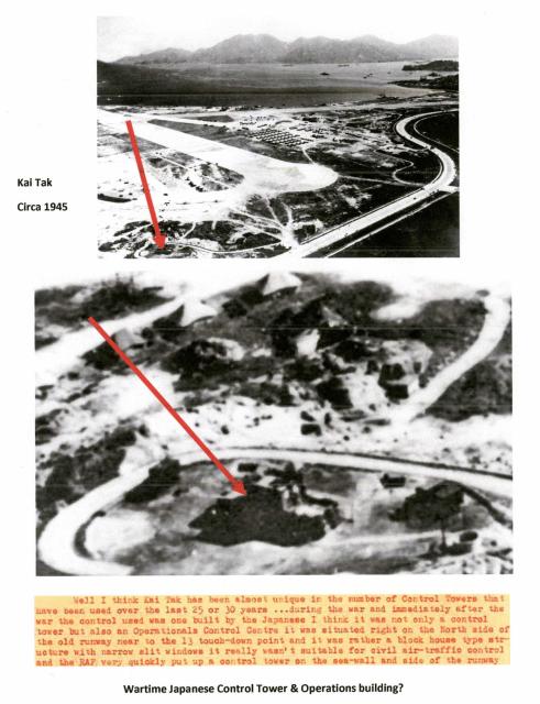
Kai Tak - Possible Control Tower Location Used by the Japanese
The location suggested of the Control Tower used by the Japanese during WWII to the east of the Runway 13 touchdown point within the airport perimeter can be seen below with the similar road pattern. Not sure if it was the same structure.
1955
1945. The location of the Control Tower used by the Japanese may be the building on or near the hillock on the right within the ring road.
1945 - Possible Location of the Japanese Used Control Tower
Re: 1945 Possible Location of the Japanese Used Control Tower
Looking at the location of the hillock. it is where the Kai Tak Amusement Park used to be.
1950 Photo of Control Tower Used by the Japanese
Ground level view of the building on the hill.
1950s Long Shot Photo of Control Tower Used by the Japanese
Updated to 1958. Cropped from this photo here
Kai Tak Japanese operations building-1955
Another interesting image.
Its surprising that no one appears to have looked for or identified this structure before, especially as its location was identified on a Kai Tak infrastructure location diagram in Captain Charles Eather’s book Airport of the Nine Dragons published in 1996.
The mound/hill is identified by the compilers of a wartime BAAG sketch map of Kai Tak as ‘Kang Hill.’
An early post-war Civil Aviation Dept. map of the airport site used in an exhibition around the time Kai Tak closed, has the mound annotated, unfortunately on my low resolution digital copy, these notes are unreadable.
The aerial overview of the north-east corner of the site on gwulo clearly shows the mound unoccupied by any buildings. It could be dated by the nearby Runway 13 extension. The gates/guard houses on the main road are not apparent in this image, so presumably not yet commissioned and in use.
Re: Japanese Built and Used Control Tower
Took me some time to find the original source photo. The long shot photo was cropped from here . Wong Tai Sin Resettlement Estate is in the background. The Estate was built between 1957 and 1959. Photos of Wong Tai Sin Estate and the former Kai Tak runways can be viewed here . In image 4 of the photo sequence as seen here , the structure on the hill appears to be intact.
BAAG sketch map of "Kang Hill" can be viewed here
Going back to the location of the Japanese built and used (Control) Tower, I do note the following from BAAG reports on Kai Tak Airfield (1942-1944):
a) 17 August 1944 - the Japanese have built a Tower on top of a hill called Un Ling (240604) to the NORTH of Kai Tak Airfield. The shape of this tower is round and it has two stories.
b) 7 September 1944 - The Governor had ordered all constructional activity on the Airfield to cease immediately.
On maps Un Ling appears to be to the east of "Kang Hill". The grid reference 240604 may be of help.
"Kang Hill" may be "Kong Hill" as in Po Kong Hill (23126013) as I note the following extract from 19 September 1944 - PO KONG HILL. There is a small rectangular house on the top, near which there are several gun emplacements. There is a road up the hill.
The structure may not be a (Control) Tower after all.
To determine the location of the structure believed to be the (Control) Tower would be to use the grid references supplied and superimpose them on a modern map.
Wong Tai Sin
Greetings. Impressive resources and help, moddsey. Thank you. These photos refresh my memories of the building I saw many years ago, since then never giving it a thought, until now. Regards, Peter