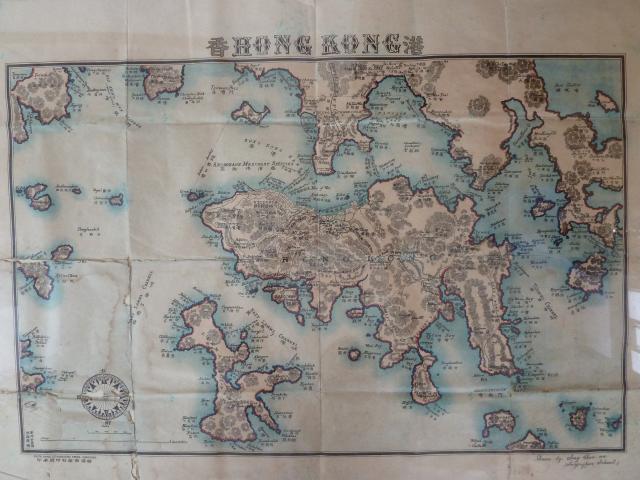
Looking for information relating to this map; probable date and anything on its origin. "Mapping Hong Kong - A Historical Atlas", by Hal Empson, has a similar map (Plate 2-11), but judging by the additional Kowloon development and land reclemation (eg Sham Shui Po) a later edition I believe. In "Mapping Hong Kong" the map is dated 1925-193? and listed as a fith edition and printed by Tungar Printing Co. Ld. and also drawn by Sung Chun Wa.
Date picture taken
unknown
Comments
The Tai Tam Tuk Reservoir
The Tai Tam Tuk Reservoir [1918.. ] isn't shown, so the map should have been drawn before 1918.
Any clues about where the map came from, ie was it part of a book, or just a loose sheet?
This copy was printed by the "South China Lithographic Press, Hong Kong". Does anyone know when they were in business?
Please can we get a sharper scan of the bottom right corner that shows the name?
Regards, David
Botom right says "Drawn by
Botom right says "Drawn by Sung Chun Wa (Saiyinpun School)".
I've found a similar map from an auction in the UK, and looks to be of the same edition, but the description just references Empson's "Mapping Hong Kong", so no additional information there.
http://www.the-saleroom.com/en-gb/auction-catalogues/dominic-winter-boo…
Is anybody familiar with the timeline of land reclamation in Kowloon - marked here as proposed?
Tai Tam Reservoirs
I also dont see the Baywash nor the Intermediate reservoirs, which I think were constructed 1904-1907. Am I wrong in this or do you perhaps think these are too small a detail to be included on this map? Are there any other contruction projectes which might help date this map?
maybe too small
it has the KCR marked on it so must at least be after 1910.
Re: Map Details
Won't be 1920s as Stubbs Road and the current road to Shek O are not shown. Proposed Kowloon Bay Reclamation (dotted lines) from 1916.are given. As you say prior to 1918 probably.
"Drawn by Sung Chun Wa (Saiyinpun School)"
I think that was a government school, so if Mr Sung was a teacher there he should be listed in the Government Blue Books (see http://gwulo.com/hong-kong-blue-books). If he's shown there, the years he worked there will help narrow down the date for this map.
Regards, David
sung chun wa's map
Some info of this map can be found at an auction site:
https://www.the-saleroom.com/en-gb/auction-catalogues/dominic-winter-bo…
Hong Kong. Sung Chun-wa (Drawn by), Hong Kong, pub. South China Lithographic Press, n.d., c.1930, col. photolitho. map, text in English and Chinese, title above image, some overall toning and slight mount staining, slight staining caused by repair tape to verso of map, slight chipping to upper margin, 460 x 650mm. Rare. Hal Empson. Mapping Hong Kong, A Historical Atlas. Plate 2-11. (1)
Sung had a later map showing the proposed reclamation between Lai Chi Kok and Tai Kok Tsui, but not indicating the land reclamation of the Kai Tak airport as in the late 1950s. That later map seems to be an update of this one.
Here is the Worldcat info on the later map: https://www.worldcat.org/title/hong-kong-drawn-by-sung-chun-wa-fifth-ed…
Inaccuracy?
Perhaps this map simply has some errors, or maybe is a combination of different maps drawn at different times? Look at the bit in Quarry Bay where the Taikoo Sugar Refinery should be. It is all jagged in this map, obviously without reclamation. But check out this map in 1899 (http://www.hkmaps.hk/map_1899.html) where Taikoo had reclaimed a fair bit of land.
Even in 1888 the map shows a straightened shoreline (http://www.hkmaps.hk/map_1888.1.html) quite unlike the raw coastline we see here.
breskvar
SUNG Chun wa's Map
Thanks to adunn for posting this fascinating map which is so difficult to date.
Notations in the margin tell us it was drawn by SUNG Chun wa of Saiyingpun School and printed by the South China Lithographic Press, Hong Kong. Altea Gallery (www.alteagallery.com/stock_detail.php?ref=16790) is selling a copy (only GBP6,000!) and dates it as circa 1924. The basis for the date isn't mentioned, but their blurb notes that the South China Lithographic Press opened in 1922, and that Saiyingpun School became King's College in 1926, so perhaps they just took the mid-point, 1924.
Noting SUNG's reference to Saiyingpun School, David suggested researching the "Blue Book" to see if and when SUNG was listed as a teacher thereat. No luck I'm afraid. Checks of Saiyingpun School from 1922 to 1925 and of King's College for 1926 don't surface him.
A feature that assists in dating the map is the ornate compass design appearing in its lower left corner. In 1936 SUNG applied to register the design as a trade mark. Here's the notification of his application.
Of particular relevance is his claim in the application to have been using the design "since 1924". Taking SUNG at his own word, the map must therefore have been drawn in 1924 at the earliest - which fits in nicely with the year of printing estimated above.
As printing in 1924 seems likely, it's surprising that the map itself doesn't show many, or indeed any (corrections welcome), new features developed during the previous decade. Logically it's the newest builds that should most accurately indicate when the map was drawn. Of all the places marked on the map, the most recent two seem to be the Taikoktsui Typhoon Shelter and the Kowloon Canton Railway (KCR) Station.
The breakwater of the Taikoktsui Typhoon Shelter is shown on the map in what appears to be its full length. It was in an advanced state of construction from 1913 until completion in August 1915 (PWD Annual Reports of 1913 & 1915, referred to as Mongkoktsui Typhoon Refuge). Meanwhile, the KCR is shown snaking south from the top of the map to its Kowloon terminus at the south-eastern tip of Tsim Sha Tsui - the site of the temporary station used from 1st October 1910 until the permanent terminus at the south-western side of the peninsular came into use on 1st April 1914 (www.kcrc.com, Annual Reports of KCR (British Section), 1910 & 1914). As the map has both the completed breakwater and the temporary KCR Station present simultaneoulsy it should logically have been drawn in 1913 or early 1914.
But if it was drawn in 1913/14, why wait until 1924 to print it? Or was it drawn and printed in 1924, but depicts the situation a decade earlier? Perhaps identifying its intended function will assist to answer the question.
The folds visible on the map suggest it was produced in the size of a small poster rather than as a page of a book. However, it's not detailed enough to have been much use for finding the way around either on land or sea. Furthermore, its a "general" map in the sense that it doesn't focus on any particular theme. However, it is visually distinct and attractive. The pink coloured land, perhaps redder before fading, with its heavily outlined coastline, is in stark contrast to the light blue of the sea. The ornate compass design and elaborate lettering of the title add further optical appeal.
The highlighting of the coastline is worth further consideration. Most of the coast has been traced with an inner line of red or pink plus a thick outer line of dark blue or black. Although the technique results in the shape of the land being highly visible from a distance, it reduces the accuracy with which the shoreline is depicted and obscures some features such as coastal roads. The technique was not used for the urban north shore of Hong Kong Island, presumably to avoid these negative consequences and preserve detail.
So the map is the size of a poster and was drawn with the apparent priorities of attractiveness and visibility rather than accuracy and detail. Sounds like its function could have been decorative - to be hung on a wall like a painting. As such, the fact that it was already at least ten years out of date by the time of printing wouldn't be so important as it was never intended to fulfill a more practical purpose.
The wording of SUNG's application to register his compass design as a trade mark raises the possibility of the map being for another purpose. He says the compass design was used, "in respect of Maps and Copy Books". The reference to "maps" is easy to understand, but "Copy Books"? Wiki tells us a "Copy Book" is a book used in education that contains examples and blank spaces for writing down copies of the examples by imitation. Copy Books are commonly used to teach penmanship, including copying labels onto maps or, in a more advanced form, copying whole maps. In support of this possibility is the profusion of place names on the map. Take Lamma Island for instance. Have you ever seen so many of its headlands and bays named? So perhaps SUNG's map was a "copy map" - a map for trainee cartographers to copy to improve their labeling and drawing skills. If so, it would not need to be up to date.
When drawing a map, it's normal practice to make extensive reference to earlier maps of the same area, making additions or deletions as appropriate to develop the new one. There's really no other efficient way. You couldn't reasonably expect every cartographer to conduct a full geographic survey prior to drawing his or her first map of an area. So which map or maps did SUNG rely upon to develop his map?
The following map by R. C. HURLEY seems to have been a major source of inspiration for SUNG for the Hong Kong Island part of his map.
Obviously different maps covering the same area will have many features in common, but it's very close similarities in how those features are drawn and labelled that can lead to the conclusion that an earlier map influenced the production of a later one. The most obvious similarity between HURLEY's and SUNG's maps are their similar and unusual styles of hachuring - an alternative method to contouring for depicting the lie of the land. Both maps use hachering to show the intermediate slopes of mountains and hills, whilst their peaks and ridgelines are often left blank, giving the inaccurate impression that these areas are plateaus, whereas in reality they are normally as precipitous as their hachured intermediate slopes.
Probably the strongest indication that an earlier map was relied upon to produce a later map is the occurrence of the same mistakes in both. I can only spot one error in HURLEY's map - High West is wrongly labelled as being directly south of Victoria Peak, whereas in fact it is to the west, almost directly between Victoria Peak and Mount Davis, where the red cross is.
SUNG's map shows the same mistake.
But HURLEY's map can't have been the only one SUNG relied upon, simply because SUNG's map covers a much wider area than HURLEY's. Nevertheless, their high degree of similarity in the hachuring and the shared High West mistake, suggest HURLEY's map was one of SUNG's primary sources.
To summarize, SUNG's map appears to depict Hong Kong as it was in 1913 or early 1914, but was not drawn and printed until at least 1924. The possibility of it being intended for decoration or as a "copy map" to assist trainee cartographers develop their skills, rather than as a direction finder, may go some way to explaining the apparent time gap.
Development of northern Kowloon
The PWD started planning for reclamation and road extension around 1921. And in 1922, it completed a Town Planning Scheme, including several development proposals like Kowloon Tong, Kai Tak and reclamation for Sham Shui Po. In a LegCo deliberation on if HK needs outside expert on planning, DPW Perkins had proudly claimed that his experience in New York and Brooklyn twenty years earlier sufficed. And the layouts in Kowloon is indeed similiar to that in Brooklyn. I causually make this comment from memory. If I have time, I will dig out more quotes and reference better. Also see Roger Bristow's book and Edward Yiu (chung-yim)'s blog at https://ecyyiu.wordpress.com/2013/10/06/the-town-planning-scheme-of-192…
Hurley also produced a 'New
Hurley also produced a 'New Territories' Map
I have found historical HK maps to contain many errors. For instance I have government maps from the 1930's showing buildings that were demolished in the 1920's. Keeping maps up to date before compute software must have been time consuming, especially as the cityscape of Hong Kong changed so quickly.
various versions of Sung's maps
Several months, I tried to tally how many editions of his maps (across several decades) from various sources such as FirstCat, the map libraries elsewhere and the auction sites. For this particular one, I tend to agree to the conclusion from gw.
Who is Sung Chun Wa? Thanks for gw, we now know Sung applied for a trademark and he was an owner of an underwear workshop.