The widening of northern part of Tsing Yi Channel & creation of typhoon shelter must be how TWCPC was increased to the size it is now. Admittedly from different angle, but from top of Lai Chi Kok today looks totally different - but then again doesn't everything? And everything change so fast, easy to miss such major works. Only in HK! |^)
With 東頭村道 on the right intersecting with 聯合道 - there even looks to be the little bend in the road to the right just past the cemetary before the junction.
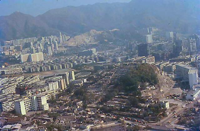
I believe that was Hau Wong Temple could be seen at the junction on the lower right, at the junction. The two long blocks further up behind Hau Wong Temple and the edge of the photo was Mei Tung Estate.
Yes T - the gap to the right of the white buildings in lower right hand corner similar to the curve in 東頭村道...
There are not buildings like those near 荃灣華人永遠墳場. Hill not look same. And buildings all around not look like 荃灣. So many buildings so soon after completion of reclamation in 葵涌 also not make sense (real 荃灣華人永遠墳場 is right next to 葵涌公園, several later 70s photos posted on Gwulo recently show very little development compared to this one in 1979). Ridge line behind also not look right, hard to make out but looks more like 飛鵝山 on the right with its top cropped.
And where did the typhoon shelter go? It is still there today - I see all this area from my window. As I not agree with a 師傅, I suggest nonsense dredging of Rambler Channel used to reclaim typhoon shelter & extend hill of cemetery as looks bigger than this. But I guess nobody notice. ;^)
Comments
Tsuen Wan Chinese Permanent Cemetery
The hill in the foreground is the Tsuen Wan Chinese Permanent Cemetery
Tsing Yi Channel widening & creation of typhoon shelter
The widening of northern part of Tsing Yi Channel & creation of typhoon shelter must be how TWCPC was increased to the size it is now. Admittedly from different angle, but from top of Lai Chi Kok today looks totally different - but then again doesn't everything? And everything change so fast, easy to miss such major works. Only in HK! |^)
-kpl.
Not look same...
...from other angles:
https://gwulo.com/atom/15928
https://gwulo.com/atom/24706
I still think looks more like:
https://gwulo.com/atom/16076
With 東頭村道 on the right intersecting with 聯合道 - there even looks to be the little bend in the road to the right just past the cemetary before the junction.
-kpl.
Re: Kowloon City
Hi There,
I believe that was Hau Wong Temple could be seen at the junction on the lower right, at the junction. The two long blocks further up behind Hau Wong Temple and the edge of the photo was Mei Tung Estate.
T
Thanks for agreement
Yes T - the gap to the right of the white buildings in lower right hand corner similar to the curve in 東頭村道...
There are not buildings like those near 荃灣華人永遠墳場. Hill not look same. And buildings all around not look like 荃灣. So many buildings so soon after completion of reclamation in 葵涌 also not make sense (real 荃灣華人永遠墳場 is right next to 葵涌公園, several later 70s photos posted on Gwulo recently show very little development compared to this one in 1979). Ridge line behind also not look right, hard to make out but looks more like 飛鵝山 on the right with its top cropped.
And where did the typhoon shelter go? It is still there today - I see all this area from my window. As I not agree with a 師傅, I suggest nonsense dredging of Rambler Channel used to reclaim typhoon shelter & extend hill of cemetery as looks bigger than this. But I guess nobody notice. ;^)
-kpl.
Definitely Kowloon
KPL and Thomas are right, this is the cemetery by Mei Tung. The large curved swath at the back is Morse Park and Junction Rd in the foreground.
Thanks for the correction, I
Thanks for the correction, I've updated the "shows Places".